the Creative Commons Attribution 4.0 License.
the Creative Commons Attribution 4.0 License.
 | 24 Mar 2022
Brief communication: Key papers of 20 years in Natural Hazards and Earth System Sciences
Animesh K. Gain
Yves Bühler
Pascal Haegeli
Daniela Molinari
Mario Parise
David J. Peres
Joaquim G. Pinto
Kai Schröter
Ricardo M. Trigo
María Carmen Llasat
Heidi Kreibich
To mark the 20th anniversary of Natural Hazards and Earth System Sciences (NHESS), an interdisciplinary and international journal dedicated to the public discussion and open-access publication of high-quality studies and original research on natural hazards and their consequences, we highlight 11 key publications covering major subject areas of NHESS that stood out within the past 20 years. The papers cover all the topics contemplated in the European Geosciences Union (EGU) Division on Natural Hazards including dissemination, education, outreach and teaching. The selected articles thus represent excellent scientific contributions in the major areas of natural hazards and risks and helped NHESS to become an exceptionally strong journal representing interdisciplinary areas of natural hazards and risks. At its 20th anniversary, we are proud that NHESS is not only used by scientists to disseminate research results and novel ideas but also by practitioners and decision-makers to present effective solutions and strategies for sustainable disaster risk reduction.
- Article
(431 KB) - Full-text XML
- BibTeX
- EndNote


Embracing a holistic earth system science approach, Natural Hazards and Earth System Sciences (NHESS) is an interdisciplinary and international journal dedicated to the public discussion and open-access publication of high-quality studies and original research on natural hazards and their consequences. NHESS publishes state-of-the-art science as well as descriptions of effective implementation of assessments and management, outreach, and education. Thus, NHESS serves a wide and diverse community of research scientists, practitioners and decision-makers concerned with detection, monitoring, analyses and modeling of natural hazards and risk. This includes the design and implementation of risk management and adaptation strategies, considering economical, societal and educational aspects. NHESS started its journey in the year 2001, when the world experienced the Gujarat earthquake with a death toll of more than 15 000 people. Since its inception in 2001, NHESS has published 3436 articles until 8 October 2021. Initially (2001–2002), the number of published issues per year was only 4, but the number increased to 6 per year during 2003–2009 and further increased to 12 per year since 2010. To highlight the diversity of the topics covered by NHESS, we developed a word cloud based on the titles of the articles that were published in the journal over the last 20 years (see Fig. 1). The word cloud represents keywords of multiple hazards, assessment methods, scales of assessment and components of risks.
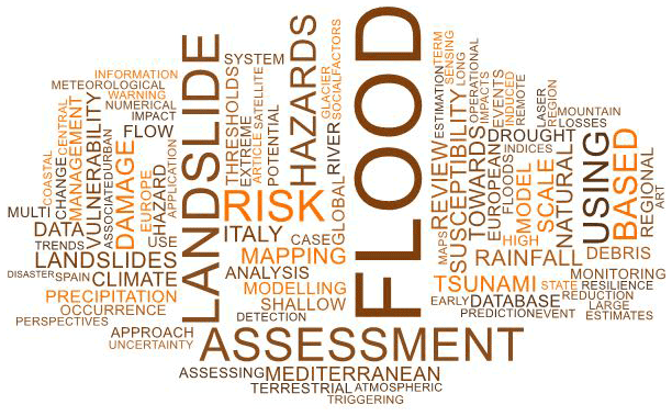
Figure 1Word cloud based on the titles of all published articles in Natural Hazards and Earth System Sciences in the last 20 years.
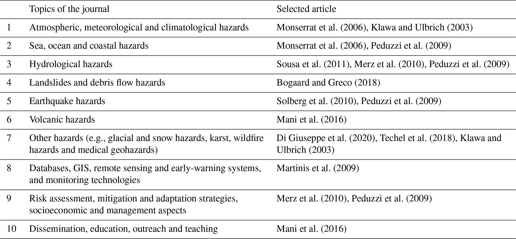
There are currently 10 thematic topics covered by NHESS (Table 1). To mark the 20th anniversary of the journal, we showcase 11 key publications that stood out within the past 20 years. The selection of articles is based on the following criteria: scientific novelty and community impact and diversity of article types. The process of selecting the key papers was driven by the first author together with the NHESS editorial board and was composed of the following steps: (1) based on high citation and download numbers as well as the expertise of the thematic editors, a short-list of 30 papers with the highest scientific novelty and community impact was compiled; (2) each of these papers was assigned to the NHESS topic it represents, some of them representing multiple topics (e.g., Merz et al., 2010; Peduzzi et al., 2009; Mani et al., 2016), and the article type was identified, such as research paper, review and invited perspective; (3) the NHESS editors discussed the selection with the aim of optimally representing the NHESS topics and reflecting the diversity of article types. The key articles were selected by consensus among the editors. Six of the hazards highlighted in our overview are closely related to weather-driven mechanisms that can be amplified by the ongoing climate change to various degrees, as mentioned in the latest Intergovernmental Panel on Climate Change (IPCC) Assessment Report (IPCC, 2021).
Table 1Representation of the NHESS topics by the selected articles.
For example, the selected article Assessment of economic flood damage (Merz et al., 2010) is one of the highly cited interdisciplinary articles (637 citations, based on a Scopus search dated 5 October 2021) and covers multiple topics such as hydrological hazards and risk assessment, mitigation and adaptation strategies, and socioeconomic and management aspects. The development of a multi-hazard disaster risk index by Peduzzi et al. (2009), a paper with 278 citations, was one of the initial contributions on quantitative assessments of risks globally, within the topic of risk assessment, mitigation and adaptation strategies, and socioeconomic and management aspects. In the topic area of remote sensing, Martinis et al. (2009) developed one of the first algorithms for near-real-time flood detection by using high-resolution synthetic aperture radar (SAR) satellite data. Klawa and Ulbrich (2003) developed one of the very first simple but effective storm loss models in the area of atmospheric, meteorological and climatological hazards. In the area of landslides and debris flow hazards, Bogaard and Greco (2018) developed a conceptual model for regional landslide hazard assessment based on physical-process understanding and empirical data. Within the topic of other hazards, we selected two very relevant recent studies: (i) predicting fire weather index by Di Giuseppe et al. (2020) based on the ensemble forecast system of the European Centre for Medium-Range Weather Forecasts and (ii) spatial consistency and bias in public avalanche forecasts by Techel et al. (2018). In the area of volcanic hazards and dissemination, education, outreach and teaching, we highlight an interesting article on the innovative use of video games for volcanic hazard education and communication by Mani et al. (2016). Considering the importance of social psychology of seismic hazard adjustment at the household level, we selected the contribution of Solberg et al. (2010). In the area of sea, ocean and coastal hazards, the contribution by Monserrat et al. (2006) on similarities and differences between seismic and meteorological tsunamis was innovative. Using multiple drought indices, the important contribution by Sousa et al. (2011) helped analyze the spatial and temporal evolution of drought conditions in the Mediterranean during the 20th century.
2.1 Economic damage assessment of floods
The review article Assessment of economic flood damage by Merz et al. (2010) is a remarkable contribution dedicated to assessment of the damage related to floods. This is a topic which is gaining increasing interest from many stakeholders since it is a crucial element in the policies of flood risk management. In times when we have to face problems linked to climate changes and adapt our way of living to mitigate the risks related to natural hazards, such an approach is of primary importance. A variety of flood inundation maps exists in the different countries of Europe, according to national laws. The flood directive of the European Union (EU) also requires Member States to map the flood extent, assess the assets and humans at risk, and take adequate and coordinated measures to reduce the flood risk (EC, 2007). In theory, flood risk maps include an assessment of the possible economic losses for society. However, this is rarely effective as many “risk maps” in practice do not cover all the needed elements and should more correctly be defined as hazard maps. The incorrect use of the terms therefore creates a serious drawback in the overall management of the risk. Typically, assessment of the hazard plays a much more prominent role than the assessment of damage, and this results in a mismatch in the quality of the available models and datasets for evaluating the economic damage. Therefore, the thorough review of methods for the assessment of economic flood damage provided by Merz et al. (2010) was and is still of high value for both practitioners and scientists, so much so that many new approaches have been developed since the review was published in 2010.
Even though the article by Merz et al. (2010) is focused on flood damage assessment, issues such as the risk-based evaluation of mitigation measures and the methodological aspects of damage estimation are valid for other natural hazards, too. This still increases its value and the positive effect on the scientific community. A crucial point, worthy of further work and of particular interest to NHESS readers, is the statement that flood risk cannot be managed alone: in areas affected by many geological hazards, these should all be considered in the policy of risk mitigation according to the magnitude of the phenomena and historical records of their effects. Introducing economic issues, such as the considerations about stock and flow values, in an article dealing with natural hazards is certainly part of a forward-looking vision, aimed at providing useful tools to decision-makers in order to develop the most proper actions for flood risk management. It has to be pointed out, however, that more efforts are needed in this direction: for instance, in addition to economic flood damage, here taken into account, the adverse social, psychological, political and environmental consequences should be examined in order to gain a comprehensive picture of the damage.
2.2 Disaster risk index
Efforts to assess and map natural hazard risk at the global scale have been ongoing since the mid-2000s in order to provide science-based information for disaster risk management. The global disaster risk management approach was formally adopted by international policies such as the Hyogo Framework For Action and the Sendai Framework for Disaster Risk Reduction. The second priority action of the Hyogo Framework For Action states that “the starting point for reducing disaster risk […] lies in the knowledge of the hazards and the […] vulnerabilities to disasters […] followed by action taken on the basis of that knowledge.” The priority was further considered by the following Sendai Framework for Disaster Risk Reduction (UNISDR, 2015). Using the definition by the United Nations Development Programme in 2004, the disaster risk index (DRI) (Peduzzi et al., 2009) was the first attempt to produce a global, quantitative approach to assessing risk due to multiple hazards. By exploring the relationship between human losses and socioeconomic and environmental variables for a variety of hazards (i.e., cyclones, droughts, earthquakes and floods), Peduzzi et al. (2009) provided the first statistical evidence of the links between vulnerability to natural hazards and levels of development at the global scale (i.e., country by country). The study helped in supporting aid organizations and governments through comparing countries across risk levels and hazard types, with an aim to make decisions on risk mitigation strategies in time. In fact, since 2009, the index has been adopted in the Global Assessment Reports (GARs) of the United Nations Office for Disaster Risk Reduction, leading in 2017 to the publications of the GAR Risk Atlas (UNODRR, 2017), which provides global multi-hazard risk metrics. The significance of the DRI is further proven by the numerous studies that were carried out in the same direction, providing alternative indexes to assess risk, at the global or at the local level. Among them, the index for risk management (INFORM) was developed by the European Joint Research Centre and is published on the homonymous webGIS platform twice a year. Additional efforts were also devoted to the inclusion of climate change impact in the evaluation. Indeed, vulnerability of a country is considered to be a key criterion also to decide on climate adaptation funding. The world risk index (WRI) can be quoted as an example in this direction. The WRI was developed by the United Nations University – Institute for Environment and Human Security (Welle and Birkmann, 2015) and is now published by the Institute for International Law of Peace and Armed Conflict of Ruhr University Bochum. It allows climate change vulnerability and adaptive and coping capacity to be taken into account.
2.3 Real-time flood detection using remote sensing
When floods strike, emergency response and disaster relief need rapid information of the situation on the ground. In this context, technological advancements open new possibilities for supporting crisis intervention. The provision of inundation extent from satellites in near-real time is one such success story. Situational awareness during floods requires reliable information with a high spatial resolution to locate the worst-hit areas and aid decision-making concerning the identification of target areas for distributing resources. Satellite data improve our capability to detect, map and monitor river floods and their impacts at local and global scales. For flood monitoring, it is advantageous and effective to utilize active sensors. In particular, radar is suitable as it penetrates rain and cloud cover, which are issues in flood-hit locations. In this regard, very high-resolution synthetic aperture radar (SAR) data show enormous potential to improve the reliability of flood mapping. However, there is usually only limited time and personnel available during emergencies to understand and process geospatial data into meaningful products. Automatic processing algorithms are crucial to reducing the time lag between data acquisition and flood map dissemination. The algorithm developed by Martinis et al. (2009) is one of the first algorithms to enable the completely unsupervised detection of inundated areas from very high-resolution SAR data in near-real time. It builds on a split-based threshold for extracting low backscattering from open flood surfaces in SAR data in a fully automatic and time-efficient manner. The segmentation of the radar scene and the context-sensitive threshold, in addition to the radar reflectivity, incorporate topological information into the classification. As the authors demonstrate, this enhances the quality of the outcomes. Notably, the algorithm does not require training data and is very suitable for applications even when the acquisition of ground-truth data is not feasible. With this development, the authors leverage very high-resolution SAR data for near-real-time flood mapping in operational flood monitoring systems and improve our emergency response capabilities (Martinis et al., 2015; Matgen et al., 2011). Today, numerous flood monitoring services are in operation using SAR data with unsupervised classification (Schumann et al., 2018). The algorithm developed by Martinis et al. (2009) is a cornerstone in this advancement.
2.4 Assessment of storm losses
The quantification and forecasting of impacts associated with the occurrence of natural hazards like windstorms or floods is of major importance for society and stakeholders (e.g., Merz et al., 2020). One of the first efforts to provide a simple but physically based quantification of windstorm-associated damage to buildings and infrastructure was the seminal work of Klawa and Ulbrich (2003). The authors considered daily maximum wind gusts from German weather stations, which were scaled by the local 98th percentile to account for local wind conditions and determine the area where damage potentially occurred (windstorm footprint). The scaled wind gusts exceeding the 98th percentile are cubed (V3) to account for the wind's destructive power and are weighted with the population density (a proxy for the local insured property). The authors found high correlations between their loss model and the loss data from the German Insurance Association.
The loss model by Klawa and Ulbrich (2003) has since proven to be a highly efficient and widely applicable approach, becoming a very popular and easy-to-use socioeconomic loss model for insurance applications and leading to a wide number of further developments and follow-up studies. For example, Leckebusch et al. (2008) developed the concept of the storm severity index (SSI) further and considered “wind tracking”, where the windstorm footprints for a certain time frame are linked together in space and time. Pinto et al. (2012) explored the differences between the extremeness of windstorms when considering purely meteorological versus population-weighted impacts.
The method has been applied to reanalysis datasets and both global and regional climate model data, permitting the quantification of the windstorm risk in Europe and elsewhere for recent and future decades (e.g., Pinto et al., 2012; Leckebusch et al., 2008). Recently, Pantillon et al. (2017) provided evidence that the impact of European windstorms is predictable with a certain level of confidence with a lead time of 2–4 d using 20 years of European Center for Medium-Range Forecasts (ECMWF) ensemble forecast data. This demonstrates the ability to assess storm damage, issue extreme weather warnings in a timely manner, and respond appropriately to avoid major damage and disruption.
2.5 Landslide triggering thresholds
Landslides triggered by rainfall cause damage and casualties worldwide (Froude and Petley, 2018). The implementation of landslide early-warning systems is one of the most important measures for protecting populations at risk. A fundamental step for setting up an early-warning system is the identification of the relationship between the precursors and landslide occurrence (Segoni et al., 2018). A large number of papers have treated this problem by attempting to derive thresholds expressed in the form of a power law between rainfall event duration and mean intensity or event rainfall (the total rainfall depth accumulated over rainfall event duration), inspired by the pioneering paper by Caine (1980). Not many researchers have questioned this method for decades.
With their invited perspective, Bogaard and Greco (2018) discussed some theoretical reasons to move beyond this traditional approach. They stress that thresholds based only on rainfall event characteristics may not sufficiently reflect the hydrological processes occurring along slopes. In particular, intensity–duration thresholds do not allow the fact that the triggering rainfall event may be just the final “push” (trigger) after a longer wet period that predisposed the slope to fail (cause) to be explicitly taken into account. They argued then that the cause–trigger concept may be better represented by hydro-meteorological thresholds. The term “hydro-meteorological” refers to the fact that these types of thresholds should combine a meteorological variable (rainfall depth) with a hydrological one, reflecting the water storage at the catchment or local scale.
Water stored in the unsaturated zone is however a variable that is more difficult to measure with respect to precipitation. On the other hand, soil moisture information is increasingly becoming available thanks to remote sensing missions. Reanalysis datasets have attracted the attention of researchers in this field as well. Within this context of an increase in availability of soil moisture information, the perspective paper soon stimulated an increasing number of scholars (i.e., cited 90 times in the last 3 years) to investigate the use of the hydro-meteorological approach to improve the performances of empirical thresholds indicating landslide triggering conditions (Mirus et al., 2018; Marino et al., 2020; Reder and Rianna, 2021). The way through this improvement remains however quite challenging. Soil moisture presents high spatial and temporal variability, and remote sensing products – as well as reanalysis ones – are available only at coarse temporal and spatial resolutions; comparisons with in situ measurements have shown that accuracy issues may be present as well. Notwithstanding such obstacles to deal with, the invited perspective is stimulating scholars to move beyond an approach that remained nearly unquestioned for many years.
2.6 The prediction of fire weather indices
Even if a commonly accepted definition is still lacking, it is becoming widely recognized that we are currently living in the Anthropocene epoch. The impact on the makeup of our planet's atmosphere as well as the disruption of many biomes and ecosystems is part of the Anthropocene fingerprint. In this context, it is important to stress that the three critical components that control the triggering and spread of wildfires (i.e., ignitions, fuels, and weather and climate) are, to a large extent, influenced by human activities. Thus, the higher concentration of greenhouse gases produced by humankind is already significantly increasing the likelihood of heat waves (Fischer and Knutti, 2015) that are often linked to more intense and prolonged fire seasons (Ruffault et al., 2020). Additionally, in many semi-arid areas of the globe the increasing temperatures coupled with a decrease in precipitation are aggravating the dryness of fuels (Abatzoglou and Williams, 2016).
Besides destroying property worth billions of euros, wildfires are still capable of impinging a disconcertingly large number of human fatalities, even in some of the most highly developed regions of the world, (e.g., Portugal in 2017, California and Greece in 2018, Australia in 2020). Prediction of many weather-driven natural hazards (e.g., heat waves, floods or tropical cyclones) reached a fairly mature standard; however, the forecast of wildfire-prone conditions still lags behind, with fire danger indicators mostly relying on environmental monitoring. In 2020, a study led by Francesca Di Giuseppe (Di Giuseppe et al., 2020) published in NHESS suggested extending fire danger warnings with the use of the most advanced weather forecast models available, i.e., the European Centre for Medium-Range Weather Forecasts (ECMWF) models. By systematically evaluating the ECMWF ensemble forecast system performance to reproduce the fire weather index (FWI) from observing stations at the global scale, the authors demonstrate the capacity of this ensemble approach to be reasonably accurate up to 10 d ahead, especially for some of the largest fires that took place in 2017, namely in Chile and Portugal. Their results confirm that early warning could be extended by up to 1–2 weeks by using advanced numerical weather models, allowing for better coordination of resource-sharing and mobilization within and across countries (Di Giuseppe et al., 2020).
2.7 Avalanche forecasting
Since the inception of the journal NHESS, more than 80 avalanche research articles have been published, covering a wide range of topics including terrain mapping, hazard and risk assessment approaches, developments in avalanche runout models, avalanche–forest interactions, assessments of risk mitigation approaches, and others. Of the many excellent contributions, we would like to highlight the paper of Techel et al. (2018), who examined the spatial consistency and bias in avalanche forecasts across the European Alps. While globally the largest number of avalanche fatalities are caused by catastrophic avalanches hitting villages or infrastructure in mountain ranges such as the Himalayas, more than 90 % of avalanche deaths in western countries involve backcountry recreationists who voluntarily expose themselves to avalanche hazard. For this user group, avalanche forecasts published by local, regional or national avalanche warning services are a critical source of information for developing an informed understanding of the existing conditions and deciding when, where and how to recreate an avalanche terrain. Despite substantial scientific advances in our understanding of the factors affecting avalanche hazard and our ability to predict it, the compilation of avalanche forecasts from a variety of different data sources still relies heavily on the personal experience and judgment of avalanche forecasters, which makes it susceptible to inconsistencies and human biases.
Focusing on the avalanche danger ratings, a prominent component of avalanche forecasts, Techel et al. (2018) show that there are considerable inconsistencies among the published ratings in the European Alps and that the largest differences are mainly found along national or agency boundaries and less between climatological or topographic regions, where one would expect them based on physical processes. These regional discrepancies make it challenging for backcountry users traveling across forecast regions to properly understand the published ratings and apply them in a consistent way. In addition, these inconsistencies can negatively affect the credibility of avalanche forecasts and lead to judicial problems in the case of avalanche accidents. While experienced forecasters were aware of this challenge, the innovative analysis approach developed by Frank Techel and his team was the first to explicitly quantify the issue in a way that circumvents the inherent challenges associated with validating danger ratings. The resulting insights have played an important role in initiating informed conversations about differences in avalanche forecasting practices and creating a meaningful foundation for evidence-based improvements in the future.
2.8 Video games as hazard education and communication
In 2015, the United Nations formalized the Sendai Framework for Disaster Risk Reduction 2015–2030, which identified the need for participating countries to “strengthen public education and awareness in disaster risk reduction”, specifically promoting the use of social media and community mobilization campaigns and encouraging the education of all at-risk communities (UNISDR, 2015). Considering the importance of science communication for the natural hazards, the topic of dissemination, education, outreach and teaching is considered to be one of the key subjects for NHESS. However, this is a less explored area in natural hazard research. Using video games for volcanic hazard education and communication by Mani et al. (2016) is one of the very few studies which contributes in this direction. They developed a video game for St. Vincent's Volcano on the eastern Caribbean island with an aim to enhance residents' education and communication of potential future volcanic hazards. The findings suggest that serious games have the potential to be effective tools in volcano education for both traditional (school students) and non-traditional (e.g., adults) stakeholder groups. Though video games are therefore a promising communication and educational technique, this approach faces a number of challenges such as expensive and time-consuming processes of game development. The study by Mani and his colleagues (Mani et al., 2016) offers exciting opportunities to build knowledge and resilience among a diverse range of social groups within at-risk communities.
2.9 The psychological factors shaping human adjustments of seismic hazards
The risk reduction efforts of natural hazards including seismic hazards are at the forefront of discussions on contemporary global forums such as the United Nations (UN) Sustainable Development Goals (SDGs) and the Sendai Framework for Disaster Risk Reduction (SFDRR) (Rahman and Fang, 2019). Besides structural measures, non-structural measures including emotional and socio-cultural factors play a key role in people's risk-related behavior for disaster risk reduction (Mohibbullah et al., 2021). As people tend to be guided more strongly by their emotional reactions than by scientific or logical approaches, psychological adaptation to disasters is an interesting area of research. Given the importance, Solberg et al. (2010) reviewed the psychological factors that shape human adjustments to seismic risk. This is one of the very few studies that synthesize the major findings from the 40 years of the international literature on the psychological adjustments of seismic hazards including the normative beliefs of earthquake protection responsibility and trust among key stakeholders of seismic risks (e.g., management authorities and local people). They also analyze the importance of seismic adjustment attributes such as beliefs about efficacy, control and fate. The findings suggest that the consideration of norms, trust, power and identity plays a key role in seismic hazard adjustment. The article by Solberg et al. (2010) stimulated interesting discussion and further development on psychological and behavioral adjustment of seismic hazard.
2.10 Meteorological tsunamis
Meteorological tsunamis (or simply known as meteotsunamis) are typically recognized as long ocean waves which have the same frequencies and spatial scales as tsunami waves of seismic origin but are produced by atmospheric processes. They are triggered by extreme weather events including severe thunderstorms, squall lines (a sudden violent gust of wind or localized storm, especially one bringing rain, snow or sleet), storm fronts, hurricanes or instable intense mid-troposphere jets. The similarity between atmospherically generated “meteotsunamis” and seismically generated tsunamis is strong enough that it can be difficult to distinguish one from the other. The article by Monserrat et al. (2006) is one of the very few studies that describes the hazardous phenomena of meteotsunamis in the world ocean to show the similarities and differences with seismic tsunamis. Analyzing several cases, Monserrat and his team found that both tsunamis and meteotsunamis have the same periods, same spatial scales and similar physical properties and affect the coast in a comparably destructive way. In addition, some specific features of meteotsunamis such as the coupling between the moving disturbance and the surface ocean waves make them akin to landslide-generated tsunamis. Monserrat et al. (2006) found that the major difference between tsunamis and meteotsunamis is associated with the specific properties (mainly the resonant factors) of corresponding sources. During resonance of the ocean driven by atmospheric forcing, the atmospheric disturbance propagating over the ocean surface is able to generate significantly long ocean waves by continuously pumping energy into these waves. This contrasts with seismic tsunamis that can have globally destructive effects without any resonant factor. However, the meteotsunamis are always local and much less energetic than seismic tsunamis. The destructive meteotsunamis are always the result of a combination of several resonant factors such as Proudman, Greenspan, shelf and harbor. As the probability of occurrence for such a combination is very low, the destructive meteotsunamis are infrequent and observed only at some specific locations in the ocean.
2.11 Drier conditions in Mediterranean regions
The Mediterranean region is considered a hot spot of climate change. This qualification is supported by different natural and socioeconomic reasons, one of them being its impact over hydrometeorological hazards, specifically, droughts. Despite the high uncertainty associated with the application of climatic models over the rainfall in this region, there is a high confidence in the drought risk increase (MedECC, 2020), mainly due to precipitation reduction, a negative trend in moisture availability and warming-enhanced evaporation. In a region where, on average, more than 65 % of the fresh water is for agriculture, around 30 % is for the direct use of water by the population, and the remaining 5 % is for industry, energy and tourism, drought increase implies that water-related intersectoral conflicts are likely to be exacerbated, even more so if we consider that in 2025 about 530 million people will live in the Mediterranean and that the increase in temperature will lead to an increase in irrigation needs from 4 % to 18 % (MedECC, 2020). Although today there are already numerous studies at the local and regional scale on the observed spatial and temporal evolution of drought conditions, the paper by Sousa et al. (2011) updated the state of the art and provided a robust and complete analysis of these conditions at the Mediterranean scale during the 20th century.
Droughts constitute a complex and difficult risk to evaluate, so it is usual to define indices to estimate their onset, duration and intensity. Sousa et al. (2011) applied the Palmer drought severity index (PDSI) adapted to Europe (scPDSI) by the Climatic Research Unit. The scPDSI is based on the water budget for a certain period estimated from precipitation, temperature and soil characteristics and is self-calibrated from local data. This index was applied to the Mediterranean region and to four selected subregions, homogeneous in terms of drought characteristics and socioeconomic relevance, for the period 1900–2000. After a robust analysis the scPDSI showed a clear trend towards drier conditions in most of the Mediterranean region. This index reproduced well the strong decadal and inter-annual variability between subregions throughout the century and showed how the drought period recorded during the 1940s was extended from Iberia until the Balkans region. Keeping in mind that determined synoptic patterns favor the deficit of precipitation and the previous literature, and after analyzing different major potential teleconnections, authors selected the North Atlantic Oscillation (NAO) and the Scandinavian index as the most representative of this region. The paper revealed the link between dry periods estimated by the scPDSI and the positive phase of the NAO during winter and subsequent climatic seasons over the western Mediterranean, while the Scandinavian index presented a less homogeneous but significant pattern between winter and summer over the central Mediterranean. Those teleconnections joined to the influence of the sea surface temperature (SST) anomalies allowed the creation of a stepwise regression model that was able to forecast summer drought conditions 6 months in advance and was capable of reproducing the observed scPDSI time series fairly well. Although it is a simple algorithm it provides a useful approach to seasonal forecasting of droughts that can be very useful in a panorama characterized by an increase in dry periods.
The above articles represent excellent scientific contributions in the major subject areas of natural hazards and risks and helped NHESS to become an exceptionally strong journal representing interdisciplinary areas of natural hazards and risks. As a pioneer of the open-access model including open discussion and peer review, NHESS promotes scientific contributions and original research on broad areas of natural hazards and their consequences. On its 20th anniversary, we are proud that NHESS is used not only by scientists to disseminate research results and innovative novel ideas but also by practitioners and decision-makers to present effective solutions and strategies for sustainable disaster risk reduction.
No data sets were used in this article.
All authors equally contributed to the paper. AKG and HK coordinated the joint effort, while all authors were responsible for reviewing, discussing and writing.
At least one of the (co-)authors is a member of the editorial board of Natural Hazards and Earth System Sciences. The peer-review process was guided by an independent editor, and the authors also have no other competing interests to declare.
Publisher's note: Copernicus Publications remains neutral with regard to jurisdictional claims in published maps and institutional affiliations.
This article is part of the special issue “Perspectives on challenges and step changes for addressing natural hazards”. It is not associated with a conference.
All authors would like to acknowledge the two reviewers (Thom Bogaard and Francesca Di Giuseppe) and the editor (Paolo Tarolli) for their insightful revisions and editing. Animesh K. Gain gratefully acknowledges the Marie Skłodowska-Curie grant agreement no. 787419, under the European Union's Horizon 2020 research and innovation program. Ricardo M. Trigo acknowledges the support of FCT through project ROADMAP (JPIOCEANS/0001/2019). Joaquim G. Pinto thanks the AXA Research Fund for support.
This paper was edited by Paolo Tarolli and reviewed by Thom Bogaard and Francesca Di Giuseppe.
Abatzoglou, J. T. and Williams, A. P.: Impact of anthropogenic climate change on wildfire across western US forests, P. Natl. Acad. Sci. USA, 113, 11770, https://doi.org/10.1073/pnas.1607171113, 2016.
Bogaard, T. and Greco, R.: Invited perspectives: Hydrological perspectives on precipitation intensity-duration thresholds for landslide initiation: proposing hydro-meteorological thresholds, Nat. Hazards Earth Syst. Sci., 18, 31–39, https://doi.org/10.5194/nhess-18-31-2018, 2018.
Caine, N.: The Rainfall Intensity – Duration Control of Shallow Landslides and Debris Flows, Geograf. Ann. A, 62, 23–27, https://doi.org/10.1080/04353676.1980.11879996, 1980.
Di Giuseppe, F., Vitolo, C., Krzeminski, B., Barnard, C., Maciel, P., and San-Miguel, J.: Fire Weather Index: the skill provided by the European Centre for Medium-Range Weather Forecasts ensemble prediction system, Nat. Hazards Earth Syst. Sci., 20, 2365–2378, https://doi.org/10.5194/nhess-20-2365-2020, 2020.
EC: Directive 2007/60/EC of the European Parliament and of the Council of 23 October 2007 on the assessment and management of flood risks, Official Journal of the European Union, https://eur-lex.europa.eu/legal-content/EN/TXT/?uri=CELEX:32007L0060 (last access: 21 March 2022), 2007.
Fischer, E. M. and Knutti, R.: Anthropogenic contribution to global occurrence of heavy-precipitation and high-temperature extremes, Nat. Clim. Change, 5, 560–564, https://doi.org/10.1038/nclimate2617, 2015.
Froude, M. J. and Petley, D. N.: Global fatal landslide occurrence from 2004 to 2016, Nat. Hazards Earth Syst. Sci., 18, 2161–2181, https://doi.org/10.5194/nhess-18-2161-2018, 2018.
IPCC: Climate Change 2021: The Physical Science Basis, in: Contribution of Working Group I to the Sixth Assessment Report of the Intergovernmental Panel on Climate Change, edited by: Masson-Delmotte, V., Zhai, P., Pirani, A., Connors, S. L., Péan, C., Berger, S., Caud, N., Chen, Y., Goldfarb, L., Gomis, M. I., Huang, M., Leitzell, K., Lonnoy, E., Matthews, J. B. R., Maycock, T. K., Waterfield, T., Yelekçi, O., Yu, R., and Zhou, B., Intergovernmental Panel on Climate Change Geneva, Switzerland, https://www.ipcc.ch/report/ar6/wg1/, last access: 21 March 2022, in press, 2021.
Klawa, M. and Ulbrich, U.: A model for the estimation of storm losses and the identification of severe winter storms in Germany, Nat. Hazards Earth Syst. Sci., 3, 725–732, https://doi.org/10.5194/nhess-3-725-2003, 2003.
Leckebusch, G. C., Renggli, D., and Ulbrich, U.: Development and Application of an Objective Storm Severity Measure for the Northeast Atlantic Region, Meteorol. Z., 17, 575–587, https://doi.org/10.1127/0941-2948/2008/0323, 2008.
Mani, L., Cole, P. D., and Stewart, I.: Using video games for volcanic hazard education and communication: an assessment of the method and preliminary results, Nat. Hazards Earth Syst. Sci., 16, 1673–1689, https://doi.org/10.5194/nhess-16-1673-2016, 2016.
Marino, P., Peres, D. J., Cancelliere, A., Greco, R., and Bogaard, T. A.: Soil moisture information can improve shallow landslide forecasting using the hydrometeorological threshold approach, Landslides, 17, 2041–2054, https://doi.org/10.1007/s10346-020-01420-8, 2020.
Martinis, S., Twele, A., and Voigt, S.: Towards operational near real-time flood detection using a split-based automatic thresholding procedure on high resolution TerraSAR-X data, Nat. Hazards Earth Syst. Sci., 9, 303–314, https://doi.org/10.5194/nhess-9-303-2009, 2009.
Martinis, S., Kersten, J., and Twele, A.: A fully automated TerraSAR-X based flood service, ISPRS J. Photogram. Remote Sens., 104, 203–212, https://doi.org/10.1016/j.isprsjprs.2014.07.014, 2015.
Matgen, P., Hostache, R., Schumann, G., Pfister, L., Hoffmann, L., and Savenije, H. H. G.: Towards an automated SAR-based flood monitoring system: Lessons learned from two case studies, Phys. Chem. Earth Pt. A/B/C, 36, 241–252, https://doi.org/10.1016/j.pce.2010.12.009, 2011.
MedECC: Climate and Environmental Change in the Mediterranean Basin – Current Situation and Risks for the Future, First Mediterranean Assessment Report Union for the Mediterranean, Plan Bleu, UNEP/MAP, Marseille, France, Zenodo, https://doi.org/10.5281/zenodo.4768833, 2020.
Merz, B., Kreibich, H., Schwarze, R., and Thieken, A.: Review article “Assessment of economic flood damage”, Nat. Hazards Earth Syst. Sci., 10, 1697–1724, https://doi.org/10.5194/nhess-10-1697-2010, 2010.
Merz, B., Kuhlicke, C., Kunz, M., Pittore, M., Babeyko, A., Bresch, D. N., Domeisen, D. I. V., Feser, F., Koszalka, I., Kreibich, H., Pantillon, F., Parolai, S., Pinto, J. G., Punge, H. J., Rivalta, E., Schröter, K., Strehlow, K., Weisse, R., and Wurpts, A.: Impact Forecasting to Support Emergency Management of Natural Hazards, Rev. Geophys., 58, e2020RG000704, https://doi.org/10.1029/2020RG000704, 2020.
Mirus, B. B., Morphew, M. D., and Smith, J. B.: Developing Hydro-Meteorological Thresholds for Shallow Landslide Initiation and Early Warning, Water, 10, 1274, https://doi.org/10.3390/w10091274, 2018.
Mohibbullah, M., Gain, A. K., and Ahsan, M. N.: Examining local institutional networks for sustainable disaster management: Empirical evidence from the South-West coastal areas in Bangladesh, Environ. Sci. Policy, 124, 433–440, https://doi.org/10.1016/j.envsci.2021.07.016, 2021.
Monserrat, S., Vilibić, I., and Rabinovich, A. B.: Meteotsunamis: atmospherically induced destructive ocean waves in the tsunami frequency band, Nat. Hazards Earth Syst. Sci., 6, 1035–1051, https://doi.org/10.5194/nhess-6-1035-2006, 2006.
Pantillon, F., Knippertz, P., and Corsmeier, U.: Revisiting the synoptic-scale predictability of severe European winter storms using ECMWF ensemble reforecasts, Nat. Hazards Earth Syst. Sci., 17, 1795–1810, https://doi.org/10.5194/nhess-17-1795-2017, 2017.
Peduzzi, P., Dao, H., Herold, C., and Mouton, F.: Assessing global exposure and vulnerability towards natural hazards: the Disaster Risk Index, Nat. Hazards Earth Syst. Sci., 9, 1149–1159, https://doi.org/10.5194/nhess-9-1149-2009, 2009.
Pinto, J. G., Karremann, M. K., Born, K., Della-Marta, P. M., and Klawa, M.: Loss potentials associated with European windstorms under future climate conditions, Clim. Res., 54, 1–20, 2012.
Rahman, A.-U. and Fang, C.: Appraisal of gaps and challenges in Sendai Framework for Disaster Risk Reduction priority 1 through the lens of science, technology and innovation, Prog. Disast. Sci., 1, 100006, https://doi.org/10.1016/j.pdisas.2019.100006, 2019.
Reder, A. and Rianna, G.: Exploring ERA5 reanalysis potentialities for supporting landslide investigations: a test case from Campania Region (Southern Italy), Landslides, 18, 1909–1924, https://doi.org/10.1007/s10346-020-01610-4, 2021.
Ruffault, J., Curt, T., Moron, V., Trigo, R. M., Mouillot, F., Koutsias, N., Pimont, F., Martin-StPaul, N., Barbero, R., Dupuy, J.-L., Russo, A., and Belhadj-Khedher, C.: Increased likelihood of heat-induced large wildfires in the Mediterranean Basin, Scient. Rep., 10, 13790, https://doi.org/10.1038/s41598-020-70069-z, 2020.
Schumann, G. J. P., Brakenridge, G. R., Kettner, A. J., Kashif, R., and Niebuhr, E.: Assisting Flood Disaster Response with Earth Observation Data and Products: A Critical Assessment, Remote Sens., 10, 1230, https://doi.org/10.3390/rs10081230, 2018.
Segoni, S., Piciullo, L., and Gariano, S. L.: A review of the recent literature on rainfall thresholds for landslide occurrence, Landslides, 15, 1483–1501, https://doi.org/10.1007/s10346-018-0966-4, 2018.
Solberg, C., Rossetto, T., and Joffe, H.: The social psychology of seismic hazard adjustment: re-evaluating the international literature, Nat. Hazards Earth Syst. Sci., 10, 1663–1677, https://doi.org/10.5194/nhess-10-1663-2010, 2010.
Sousa, P. M., Trigo, R. M., Aizpurua, P., Nieto, R., Gimeno, L., and Garcia-Herrera, R.: Trends and extremes of drought indices throughout the 20th century in the Mediterranean, Nat. Hazards Earth Syst. Sci., 11, 33–51, https://doi.org/10.5194/nhess-11-33-2011, 2011.
Techel, F., Mitterer, C., Ceaglio, E., Coléou, C., Morin, S., Rastelli, F., and Purves, R. S.: Spatial consistency and bias in avalanche forecasts – a case study in the European Alps, Nat. Hazards Earth Syst. Sci., 18, 2697–2716, https://doi.org/10.5194/nhess-18-2697-2018, 2018.
UNISDR: Sendai framework for disaster risk reduction 2015–2030, The United Nations International Strategy for Disaster Reduction, Geneva, https://www.undrr.org/publication/sendai-framework-disaster-risk-reduction-2015-2030 (last access: 21 March 2022), 2015.
UNODRR: The GAR atlas: Unveiling global disaster risk, UNODRR – The United Nations Office for Disaster Risk Reduction, https://www.undrr.org/publication/gar-atlas-unveiling-global-disaster-risk (last access: 21 March 2022) 2017.
Welle, T. and Birkmann, J.: The World Risk Index – An Approach to Assess Risk and Vulnerability on a Global Scale, J. Extrem. Events, 02, 1550003, https://doi.org/10.1142/S2345737615500037, 2015.