the Creative Commons Attribution 4.0 License.
the Creative Commons Attribution 4.0 License.
 | 22 Dec 2022
Tsunami risk perception in central and southern Italy
Lorenzo Cugliari
Massimo Crescimbene
Federica La Longa
Andrea Cerase
Alessandro Amato
Loredana Cerbara
The Tsunami Alert Centre of the National Institute of Geophysics and Volcanology (CAT-INGV) has been promoting, since 2018, the study of tsunami risk perception in Italy. Between 2018 and 2021 a semi-structured questionnaire on the perception of tsunami risk was administered to a sample of 5842 citizens residing in 450 Italian coastal municipalities, representative of more than 12 million people. The survey was conducted with the computer-assisted telephone interviewing (CATI) methodology, described in Cerase et al. (2019), who published the results of the first pilot survey (about 1000 interviews). The large sample and the socio-demographic stratification give an excellent representation of the resident population in the surveyed Italian coastal municipalities. Moreover, in 2021 an optimized version of the questionnaire was also administered via Telepanel (a tool for collecting proportional and representative opinions of citizens) that was representative of the Italian population and included 1500 people distributed throughout the country.
In this work we present the main results of the three survey phases, with a comparison among the eight surveyed regions and between the coastal regions and some coastal metropolitan cities involved in the investigations (Rome, Naples, Bari, Reggio Calabria, and Catania).
Data analysis reveals heterogeneous and generally low tsunami risk perception. Some seaside populations, in fact, show a good perception of tsunami risk, while others, such as in Apulia and Molise, reveal a lower perception, most likely due to the long time elapsed since the last event and lack of memory. We do not find relevant differences related to the socio-demographic characteristics (age, gender) of the sample, whereas the education degree appears to affect people's perception. The survey shows that the respondents' predominant source of information on tsunamis is the television and other media sources (such as newspapers, books, films, internet), while the official sources (e.g., civil protection, local authorities, universities and research institutes) do not contribute significantly. Also, we find an interesting difference in people's understanding of the words tsunami and maremoto, the local term commonly used in Italy until the 2004 Sumatra–Andaman event, which should be taken into account in scientific and risk communication. The Telepanel survey, based on a nationwide sample, highlights a lower level of tsunami risk perception in comparison to average risk perception levels found in the coastal-municipality sample.
Our results are being used to drive our communication strategy aimed at reducing tsunami risk in Italy, to activate dissemination and educational programs (data driven), to fill the data gap on tsunami risk perception in the North-Eastern Atlantic, Mediterranean and connected seas (NEAM) area, and to implement multilevel civil protection actions (national and local, top-down and bottom-up). Not least, outputs can address a better development of the UNESCO Tsunami Ready program in Italy.
- Article
(4613 KB) - Full-text XML
- BibTeX
- EndNote


The Mediterranean region is highly exposed to tsunami risk, as witnessed by several recent events (Yalçıner et al., 2017; Cirella et al., 2020; Dogan et al., 2021; Kalligeris et al., 2022), basin-wide or local historical events (Solov'ev et al., 2000; Mauelshagen, 2007; Maramai et al., 2014; Papadopoulos et al., 2014; Maramai et al., 2021), and a recent assessment of seismically induced tsunami hazard (Sørensen et al., 2012; Basili et al., 2021a). However, the tsunami risk in the Mediterranean is thought to be underrated, due to the low frequency of events, as in other regions of the world (Dawson et al., 2004; Dogulu et al., 2014; UNESCO-IOC, 2017; Amato, 2020; Necmioğlu et al., 2021). It is therefore important to raise awareness among people, as well as of that local authorities responsible for civil protection measures and emergency management and national/regional authorities.
The Sendai Framework for Disaster Risk Reduction 2015–2030 gives high attention to early warning systems (EWSs), suggesting to “invest in, develop, maintain and strengthen people-centered multi-hazard, multisectoral forecasting and early warning systems …; develop such systems through a participatory process; [and] tailor them to the needs of users, including social and cultural requirements, in particular gender”. The strong emphasis on people means that any communication strategy should be based on a preliminary assessment of people's knowledge, awareness, and perception of the risk. Moreover, the “needs of users” must be studied and understood to reach people and communities in the right way using the best language and communication channels and to have an optimal response in the case of an impending inundation.
The Italian Tsunami Alert Centre (Centro Allerta Tsunami, CAT) of the Italian National Institute of Geophysics and Volcanology (INGV) is part of the national tsunami warning system called SiAM (Italian national warning system for tsunami of seismic origin), established in 2017 with a prime minister directive (G.U. n.128 del 05-06-2017). SiAM is coordinated by the national Civil Protection Department (DPC) and, besides CAT-INGV, includes the Italian Institute for Environmental Protection and Research (ISPRA, Istituto Superiore per la Protezione e la Ricerca Ambientale), which manages the national sea level network and contributes to mapping the tsunami inundation zones. CAT acts as the tsunami service provider (TSP) for UNESCO member states of the North-Eastern Atlantic, Mediterranean and connected seas (NEAM) region (Amato et al., 2021), as well as the national tsunami warning center (NTWC) and tsunami warning focal point (TWFP) for Italy. Among the tasks of CAT, besides the tsunami surveillance/warning and the hazard assessment, there are also scientific and risk communications activities on tsunamis. CAT manages a dedicated website (http://www.ingv.it/cat/en/, last access: 18 July 2022), where people can find information on tsunami hazard/risk, on the warning system, and on historical events, as well as news on projects, papers, campaigns, and drills.
From this perspective, the activities of CAT include assessing people's perception of tsunami risk. This research aims to improve risk analysis and decision-making, develop methods for eliciting opinions about risk, and provide a basis for understanding and anticipating possible public reactions to tsunami hazards, enhancing risk communication among lay people, technical experts, and policy makers (Slovic et al., 1982; Slovic, 1987; Wildavsky and Dake, 1990; Slovic, 2001; Rippl, 2002).
This paper presents data on tsunami risk perception collected in central and southern Italy between 2018 and 2021. The study involved the administration of a semi-structured questionnaire to a sample of 5842 people in 450 coastal municipalities.
Risk perception studies taking into account socio-cultural and psychological aspects assess people's response to natural hazards and the behaviors they would adopt in response to risks. People's perceptions – individually or collectively – of a natural hazard are also influenced by individual factors such as personality, age, beliefs, gender, education level, knowledge, and culture (Slovic et al., 1982; Slovic and Peters, 2006; McIvor et al., 2009; McNeill et al., 2013; Wachinger et al., 2013).
Human behavior is driven by perceptions (Slovic, 1987) rather than scientific knowledge about “facts” (Renn, 1990). Therefore, it becomes strategic for those involved in risk mitigation and communication to have in-depth studies on the process that influences our ability to assess the risk of a natural phenomenon (Slovic, 1982) like tsunamis. Tsunamis are known to be a phenomenon with a low probability of occurrence but high impact, able to produce devastating consequences that can affect large areas and have serious consequences for human lives (Behrens et al., 2021; Rafliana et al., 2022). Their low frequency of occurrence is one of the variables that directly affects risk perception. In some Mediterranean areas (such as Italian coastal regions), tsunamis seem to be out of the collective consciousness, leading authorities to underestimate the significance of tsunami risk perception among the population and not take effective action to reduce the risk.
However, tsunamis' low frequency of occurrence does not reduce their destructive potential. Moreover, how important it is to study people's perceptions of natural hazards (Lindell and Perry, 2000; Paton et al., 2010; Wachinger et al., 2013; Bonaiuto et al., 2016), particularly tsunami risk perceptions, has emerged in various studies conducted in countries that have been affected by tsunamis, such as the 2004 Indian Ocean tsunami or the 2011 Tōhoku, Japan, tsunami (Kurita et al., 2007; Sugimoto et al., 2010; Alam, 2016; Arias et al., 2017; Akbar et al., 2020).
A historical catalog of observed tsunami effects in the Mediterranean (Maramai et al., 2014) cites over 200 documented events for the whole area, 90 % of which were caused by earthquakes. More recently, in the Euro-Mediterranean area, 31 earthquakes above magnitude 5.5 occurred at sea or near the coast between 2017 and October 2022, triggering the activation of CAT. Among them, 10 earthquakes generated an alert level for possible sea level change, including 6 advisory (possible sea level change with estimated run-up less than 1 m) and 4 watch (possible sea level change with estimated run-up values above 1 m) alerts. Two of them caused damage in Greece and Turkey (Yalçıner et al., 2017; Dogan et al., 2019, 2021; Triantafyllou et al., 2021; Kalligeris et al., 2022).
In addition, variables to be considered from a comprehensive perspective include the large growth in population living along the Euro-Mediterranean coasts. This phenomenon, which has occurred since the Second World War and has intensified in recent decades, also includes the development of tourist facilities and large industrial complexes. These intensive forms of settlements require multi-risk analytical hazard approaches, where the socio-cultural and psycho-social aspect becomes prominent. In this framework, strengthening tsunami risk perception studies is needed, surveying the opinions of employees; daily commuters; seasonal workers; and tourists, whose presence dramatically increases the risk during holiday seasons. The need to assess tsunami risk perception has been highlighted by several authors as a key to improving emergency behaviors and minimizing population risk by limiting casualties and infrastructure damage (Ho et al., 2008; Martin et al., 2009; Ritchie and Roser, 2014; EMDAT, 2019).
Since 2018 CAT-INGV has been promoting tsunami risk perception studies to provide oriented support to civil protection activities and develop data-driven, context-appropriate risk communication strategies. We adopted CATI (computer-assisted telephone interviewing) questionnaire structuring and administration methodology since it proved to be an excellent tool to collect a large, standardized, retraceable, and cost-effective number of data (Dawson et al., 2004; Cerase et al., 2019). Furthermore, the questionnaire as a survey method to study tsunami risk perception is widely used in the international context (see for example Apatu et al., 2016; Sun et al., 2013; Lindell et al., 2015, 2016; Jon et al., 2016; Fraser et al., 2016; Wei et al., 2017; Buylova et al., 2020).
3.1 The tsunami risk perception questionnaire
In this study we have used the questionnaire designed and described in Cerase et al. (2019; available in the English version in the paper's supplementary materials), consisting of 6 sections and 27 items that allow us to detect respondents' opinions regarding tsunami knowledge, risk perception, representation, and cultural attitudes toward risks (Douglas and Wildavsky, 1982) and through which channels respondents have been informed about tsunamis and would like to receive an alert in the case of a tsunami.
This questionnaire, implemented and administered in 2018, was subsequently adopted in two other surveys carried out in 2020 and in 2021, extending the coverage to six more Italian regions and achieving a better statistical representativeness.
3.2 Study area and sample characteristics
The coastal belts are among the most densely populated territories of the Mediterranean, where several large urban centers and some industrial activities have developed. In 2012, 40.8 % of the European Union (EU) population (about 200 million) lived in coastal regions, which comprised about 40.0 % of the EU 27 territorial extension, with an average population density of 100 inhabitants km−2 (Collet and Engelbert, 2013). Moreover, in 2018, 28 % of the Italian population (more than 17 million inhabitants) resided in coastal municipalities (ISTAT, 2020a; ISTAT is the Italian National Institute of Statistics). Between 1951 and 2011, the increase in coastal population was about 29 %. The eight regions surveyed together represent about 78 % of the national coastline. Coastal areas are also among the most densely populated with an average of 398 inhabitants km−2 – with peaks of more than 500 inhabitants km−2 in the metropolitan areas of Genoa, Rome, Naples, Palermo, Catania, and Bari – compared to an average of 167 inhabitants km−2 in non-coastal areas (ISTAT, 2020b).
Our survey was carried out in three different phases. The first survey was carried out in 2018 (4 April to 4 May) and covered the Apulia and Calabria regions where 1021 questionnaires were collected (Cerase et al., 2019). In the second survey phase, carried out between 27 December 2019 and 8 January 2020, 614 questionnaires were collected in the coastal municipalities of Molise, Basilicata, and eastern Sicily. In the third survey phase, completed in 2021 (between 21 December 2020 and 8 January 2021), 4207 questionnaires were collected in the coastal municipalities of Latium, Campania, Sardinia, and southern and northern Sicily. At this stage, research only considers permanent residents in coastal municipalities: therefore, seasonality is not deemed to affect the results.
The 2021 administration included all the coastal metropolitan cities of central and southern Italy (ISTAT, 2020b). This is relevant for civil protection because Naples, Rome, Palermo, Messina, and Catania are some of the most densely populated Mediterranean coastal cities (UNESCO-IOC, 2020; Collet and Engelbert, 2013). Adding to these cities also Bari, Reggio Calabria, and Cagliari, also sampled in 2018 and 2021, we represent about 6 million coastal inhabitants.
All these regions were chosen because southern Italy, particularly the Ionian side, has the highest tsunami hazard (Basili et al., 2019, 2021) compared to other Italian regions (Liguria, Marche, Abruzzo, Veneto, etc.). We are planning to complete, in the next 1 to 2 years, the questionnaire administration along the coastal areas of the remaining regions in order to have a comprehensive view of the Italian coastal territory on tsunami risk perception.

Table 1 shows the numerical distribution of the sample by survey stage and region. The survey covered a total of 8 regions with 37 provinces, achieving 69.8 % coverage of coastal municipalities for a total of 6166 km of coasts surveyed and 5842 interviews conducted, which are considered representative of 12 484 236 residents (ISTAT, 2021).
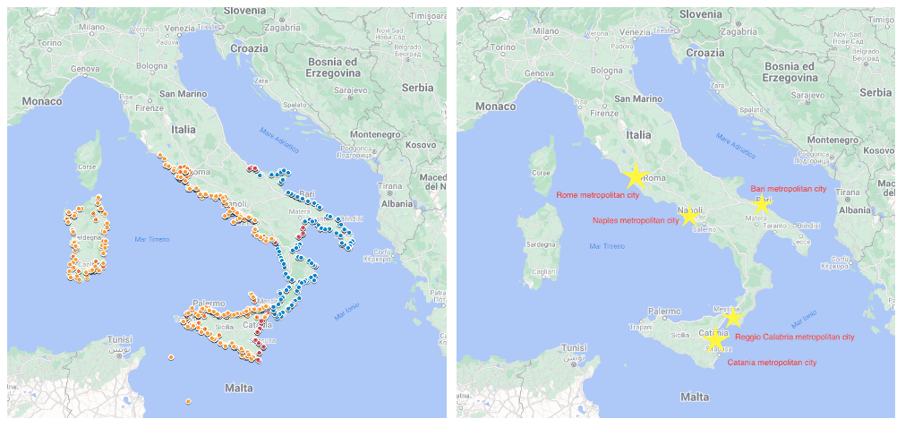
Figure 1Maps of the CATI interview distribution (left) and coastal metropolitan cities (right). The differently colored circles, on the left map, indicate the interview distribution in the different survey phases: blue shows the interviews in the first survey phase (2018); red shows the second survey phase (2020); orange shows the distribution of interviews in the third survey phase (2021). Yellow stars, on the right map, indicate metropolitan cities (provincial capitals) where population density is high for a wide territorial area. Map data modified from © Google Maps 2022.
Figure 1 shows the geographical distribution of interviews by stage and by regions.
The sampling design was structured respecting robust statistical standards with attention to the population representativeness of even smaller coastal municipalities.
The survey sample is stratified by quota (not a probability sample). The stratification is made by territory (municipalities of coastal regions), and the quotas are identified by age and gender. In order to have a more statistically robust sample, education degree was considered a quota for the third survey stage (n = 4207). The sample size reflects a choice to ensure 95 % reliability of the estimates considering each quota as a simple random sample. Thus, the overall sample design ensuring the estimates' reliability and control for sampling error variability is guaranteed.
3.3 Sample validation for the three survey phases (Cronbach's alpha and t test), statistical data processing
Since the three surveys were carried out in different years, great methodological accuracy and some preliminary statistical operations to validate and verify the data were required.
First, we verified that the samples were statistically uniform, independent, and representative in estimating the reference population mean. Further, we checked whether the datasets could be aggregated into a single matrix to produce robust outputs and correlations. For this, we used the t test (or Student's test) (Student, 1908). In our case, we applied the t test to questionnaire item nos. 8, 12, 14, 16, and 20, which are multiple-choice questions, and to nos. 21, 23, and 24, which are Likert-scale question batteries, between the first and the second surveys (2018–2020) and between the first and third surveys (2018–2021), respectively. The results of the t test with a confidence interval of 95 % confirm that the samples are statistically uniform; comparable; and, consequently, analyzable in a single data matrix. The same test has been used in similar research on tsunami risk perception to compare averages of surveyed groups (see, e.g., Akbar et al., 2020; Buylova et al., 2020; Musacchio et al., 2021; Liu et al., 2021).
Once we had obtained the t-test confirmations, we verified that the collected data were consistent and significant as a part of a robust sample. We calculated Cronbach's alpha (Cronbach, 1951, 1988) on the items comprising questionnaire section numbers 2, 3, 4, 5, and 6. The resulting alpha values in the range 0.61 ≤ α ≤ 0.83 are generally considered optimal to corroborate the variable reliability (Nunnally, 1975). Particularly, values near α = 0.80 or greater have an optimal consistency degree (Peterson, 2014). The alpha values resulting from our comparisons were in the range 0.74 ≤ α ≤ 0.89, therefore suggesting the statistical uniformity of the whole sample.
3.4 The national sample
In 2021 we administered a questionnaire to a representative sample of the whole Italian population distributed by proportional shares.
This has been done through a digital platform that reaches users – who are registered with the proprietary company – through a link on their smartphones (named Telepanel by the company). The link allows access to the online, re-adapted questionnaire that users independently complete. Survey respondents are subscribed to the service and are paid by the commissioning company. The company (CSA Research, a specialized market research and opinion survey company), as owner of the sample, takes care that it respects scientific criteria and that the sample reproduces the same compositions of the population strata. The sample is generally used to survey shared-interest opinions, political polls, national trends, and customs.
Proportional shares are respected, and the sample is stratified according to the following variables: age, gender, geographic area, educational degree, and profession.
The national sample questionnaire surveyed the opinions of 1500 respondents and was administered in the same period of the 2021 CATI survey.
The national sample is built under different criteria due to the different nature of interviewee selection, and it is used only as a term of comparison (see Sect. 4.1.3).
The principal results of the three surveys are presented in two subsections: “Tsunami risk perception” and “Tsunami knowledge”.
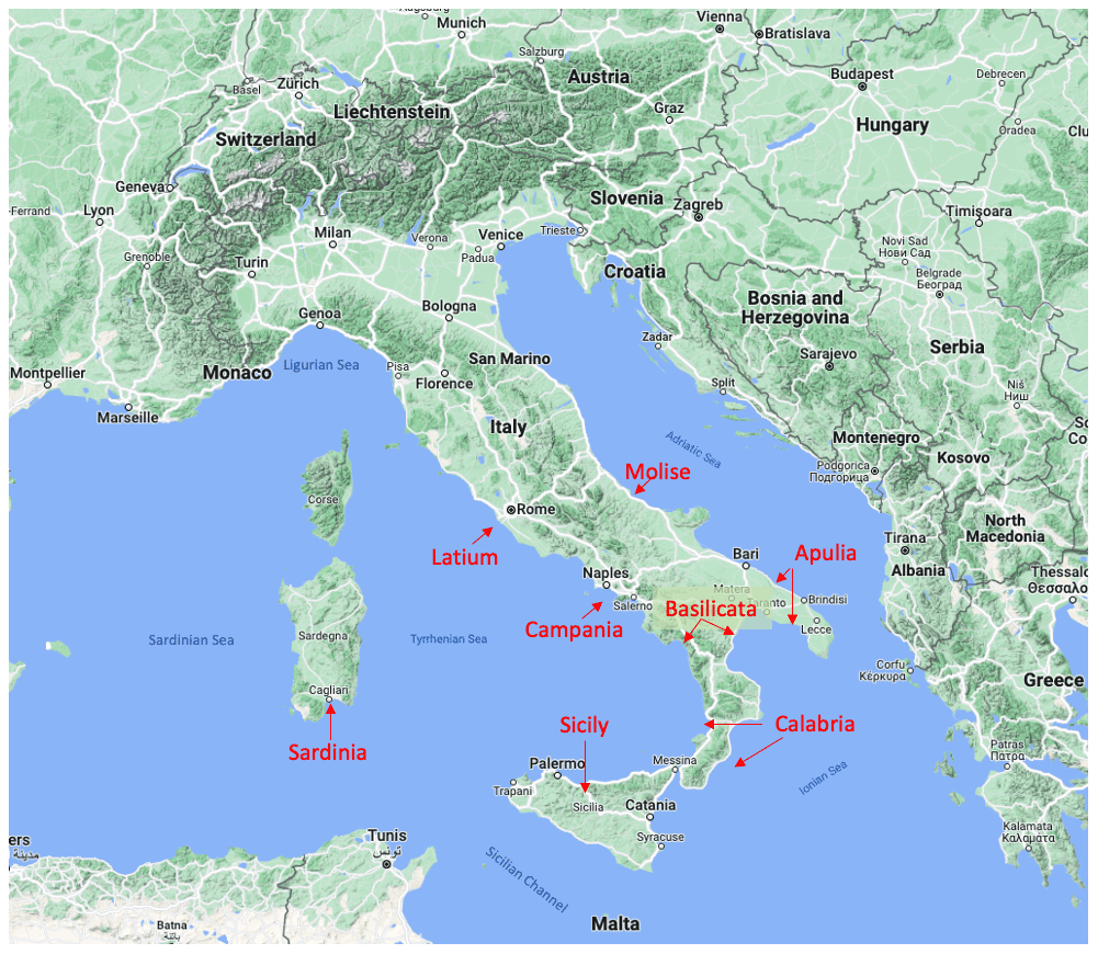
Figure 2Map data modified from © Google Maps 2022. Map of surveyed Italian coasts and corresponding seas.
The map in Fig. 2 shows the geographical positions of the coastal areas where the survey was conducted (by region) and the seas surrounding Italy.
4.1 Tsunami risk perception
Risk perception is preliminarily calculated considering the items Q13, “In the Mediterranean Sea the occurrence of a tsunami is …?”, and Q16, “Do you think that the coast of your municipality could be hit by a tsunami?”
Survey data show that tsunami risk perception differs in relation to the seaside.
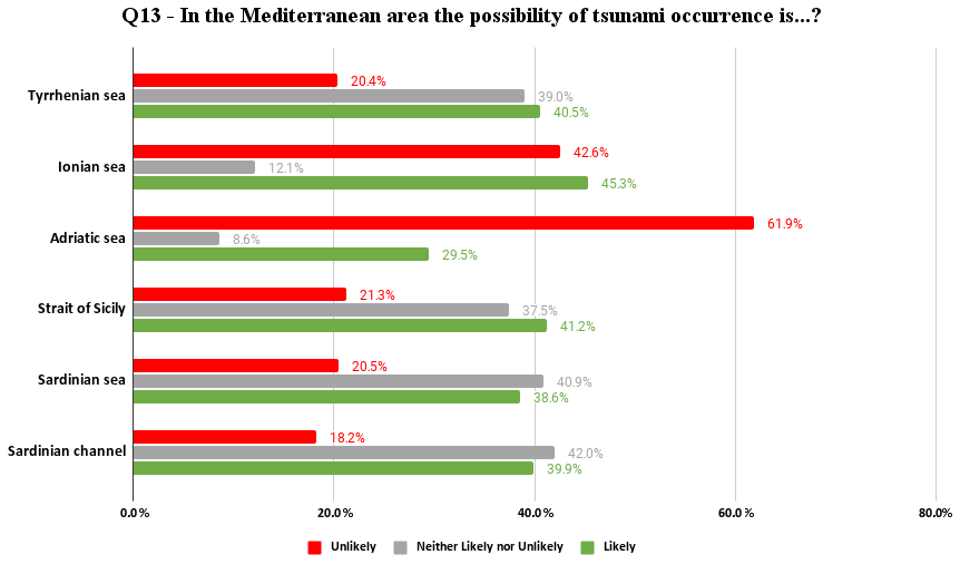
Figure 3 shows tsunami risk perception for events in the Mediterranean divided by respondents' coastal seaside location.
In general, around 40 % of the interviewees believe that a tsunami is likely to occur in the Mediterranean, except for the Adriatic Sea where the percentage is around 30 %. Even more evident is the difference between Adriatic and other seas if we look at the respondents to the “unlikeness” of such an event: more than 60 % in the Adriatic vs. ∼ 20 % of the Tyrrhenian Sea, Strait of Sicily, Sea of Sardinian, and Sardinian Channel. Midway we find the Ionian Sea (43 %), probably due to a mix between regions with memory of the 1908 event (Calabria and eastern Sicily) and the Adriatic coasts of Apulia, where most recent tsunamis date back to the 18th century (Cerase et al., 2019).
If we look to the response values of “neither likely nor unlikely” we found high percentages of around 40 % for all coasts except Ionian (12 %) and Adriatic (9 %). These high percentages are probably also associated with low tsunami knowledge, especially if contextualized with regards to the Mediterranean Sea by the population.
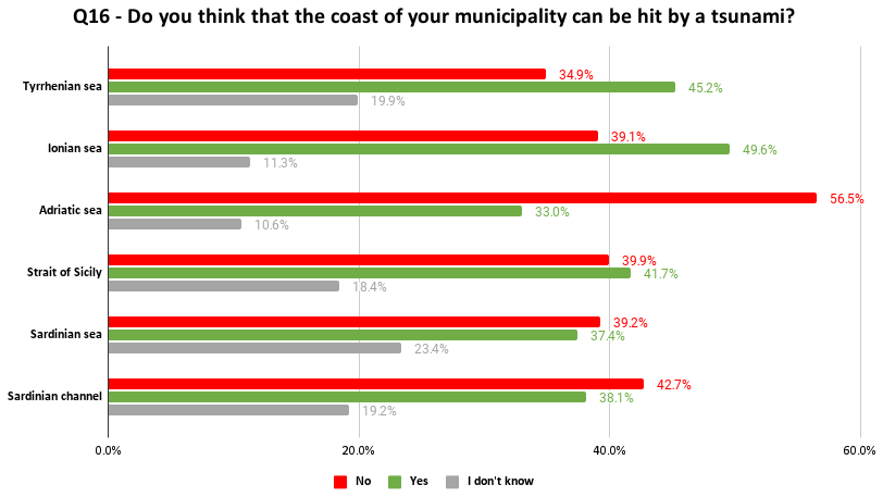
Figure 4 shows the distribution of answers to the specific question about the likelihood of a tsunami hitting the respondents' municipalities. The samples from the Ionian and Tyrrhenian sides seem to have a higher tsunami risk perception (49.6 % and 45.2 %, respectively). Differently, in the Adriatic coast municipalities, respondents have a lower perception of tsunami risk, as with the previous question (Fig. 3). In fact, only 33 % of them believe that their municipality may be affected by a tsunami, and 56.5 % believe it will not.
In the three-stage survey sample (n = 5842), no significant variations are observed for the tsunami risk perception in relation to the gender of the respondents.
More significant differences emerge in relation to educational degrees. The sample with a low educational degree showed more uncertainty in responses associated with the “I don't know” modality (23.4 % and 23.1 %, respectively, versus 11.2 % of those with high educational degrees and 15 % of those with medium educational degrees); a higher educational degree is correlated with a significantly higher tsunami risk perception, 48.2 % compared to 37.9 % for those with a lower educational degree.
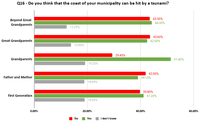
Figure 5Q16 – tsunami risk perception in municipalities according to the numbers of generations of residence in the area.
The graph in Fig. 5 – reporting the tsunami risk perception in municipalities according to the numbers of generations of residence in the area – shows an interesting finding. In fact, risk perception is highest at 51.4 % for the third generation (“my grandparents lived there”), whereas the average response rate for other generations is about 40 %. These findings are consistent with recent studies based on an interdisciplinary historical–anthropological approach (e.g., Garnier and Lahournat, 2022). Indeed, these studies highlight the role of memory transmission of past disasters and more generally cultural memory as an effective tool for disaster risk reduction (DRR; Brokensha et al., 1980; Fernando, 2003; Gregg et al., 2006; Cohen, 2011; Sutton et al., 2021).
4.1.1 Tsunami risk perception in surveyed regions
This subsection builds on the results of the paper by Cerase et al. (2019), where a significant difference in tsunami risk perception between Apulia and Calabria was found, despite the comparable, high tsunami hazard of the two regions (Basili et al., 2021). In the first region only 30 % of respondents think their region could be hit by a tsunami and 57.5 % think it could not, whereas the results for Calabria are very different, with more than 66 % yes and 25 % no (Fig. 6).
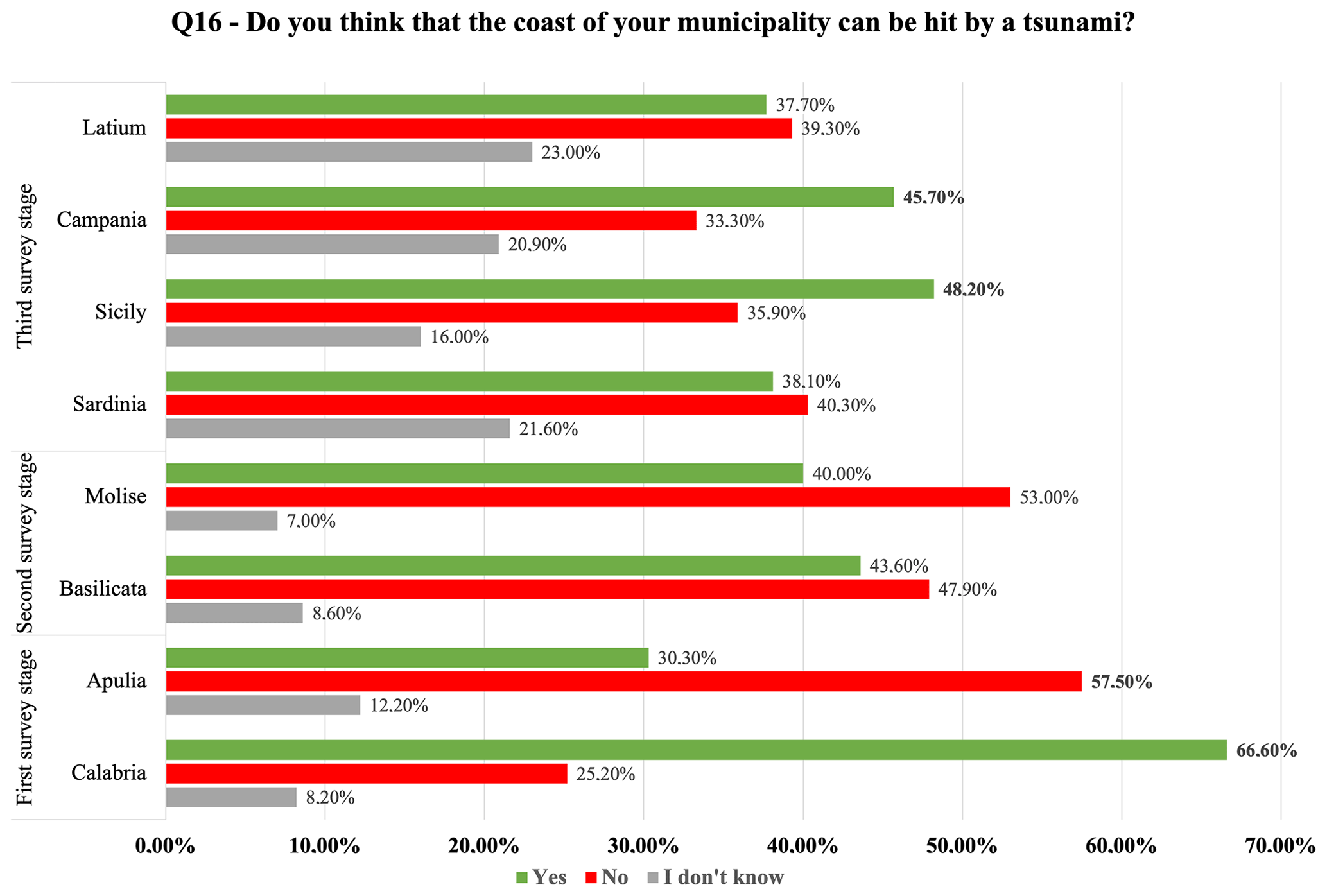
Figure 6Q16 – tsunami risk perception in respondent's municipalities according to the regions.
In order to verify the perception of other regions' inhabitants, we have compared the answers to the same question (Q16) related to the regions investigated in the second and third survey phases.
The graph below (Fig. 6) shows the percentages of responses collected for Q16 for all the regions. The results show a strong heterogeneity among different regions, with the aforementioned Calabria and Apulia as end-members of risk perception. Molise, adjacent to Apulia in the Adriatic Sea, is on the low-perception side with slightly higher values than the latter (40 % yes, 53 % no). Basilicata, with a few municipalities on both the Ionian and the Tyrrhenian coasts, has a slightly higher perception, with 44 % yes and 48 % no. Moving to the central Tyrrhenian Sea, Latium and Sardinia show equal distributions of yes and no with a large number of “I don't know” (40 %, 40 %, and 20 %, respectively). Historical catalogs do not report relevant tsunamis for these two regions. Southern Tyrrhenian regions (Campania and Sicily) exhibit higher risk perception (48 % and 46 % yes, 36 % and 33 % no, respectively), even though it is not as high as that of Calabria. This can be explained by the presence of known tsunamis (such as the 1908 event) or known potential tsunami sources, such as active volcanoes of the Neapolitan area and in the southern Tyrrhenian area).
These results are consistent with a similar study by Gravina et al. (2019). In that case, inhabitants from southern Italian regions facing the Tyrrhenian Sea were asked, “Do you consider [yourself] to be actively exposed to a tsunami risk?”. Among interviewees, 21 % answered “highly”, more than 42 % “quite”, and over 30 % “low”. Nonresponses were 9 %.
In addition, these regions, including Calabria, are highly seismically active, and people experienced frequent and even strong earthquakes. The traces of these events, present in the territory, are likely to increase people's memory of them from generation to generation.
4.1.2 Tsunami risk perception in metropolitan areas and seaside areas
We started from the research hypothesis that the perception of tsunami risk could be different between the inhabitants of metropolitan cities and those residing in the municipalities of the respective coast. In our opinion, this comparison is particularly relevant for metropolitan cities in which the exposed value (in terms of human lives, industries, and infrastructures) is considerably higher than the adjacent, less populated coasts.
Table 2Sample size data by metropolitan area and seaside area (source – ISTAT, 2022; database accessed in August 2022).
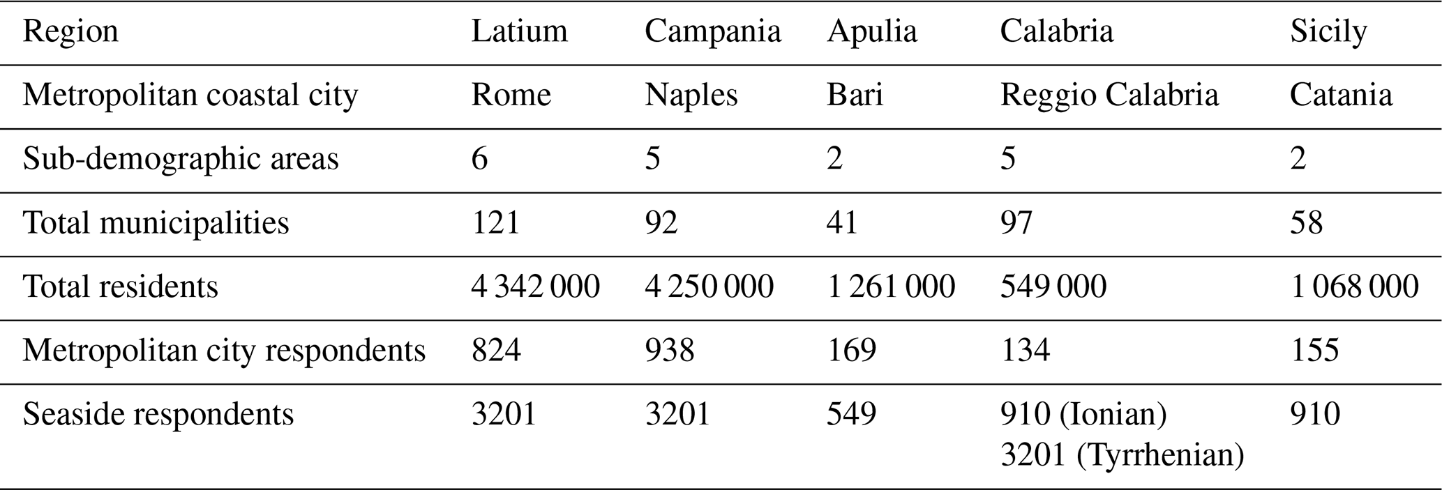
The following graphs (Figs. 7–11) show the risk perception surveyed in coastal metropolitan cities (Rome, Naples, Bari, Reggio Calabria, and Catania) in relation to the risk perception of the seaside area where the city lies (Table 2).
To prevent statistical bias, the data for each individual metropolitan city were removed from the coastal data on which the city is located. We also carried out the t test for independent samples from which a significant difference between the averages of the two samples (metropolitan cities and coastal area) was found. We used the test to indicate the sample statistical uniformity and comparability.
The graph in Fig. 7 shows the comparison between the sample of the Metropolitan city of Rome and the relative Tyrrhenian coastal area. In the case of the metropolitan city of Rome it is important to remember that Rome (2.7 million inhabitants) cannot be considered entirely a coastal city, even if some densely populated districts (like Ostia, with its 231 000 inhabitants) are entirely located on the seaside.
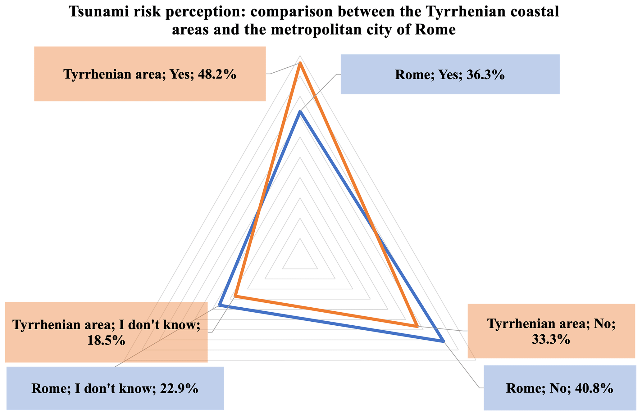
Figure 7Tsunami risk perception: comparison between the Tyrrhenian coastal area and the metropolitan city of Rome. (Q16 – Do you think that the coast of your municipality could be hit by a tsunami?)
This is probably the reason why the average of the tsunami risk perception in Rome (Fig. 7) seems to be lower than for the Tyrrhenian area. Indeed, only 36.3 % of the respondents believe that a tsunami may hit their municipality, versus the 48.2 % of respondents living on the Tyrrhenian seaside.
Tsunami risk perception in the metropolitan city of Naples (Fig. 8) is almost the same as the average surveyed on the Tyrrhenian side. Among respondents, 47.2 % said that a tsunami could hit the coasts of their municipality compared to the Tyrrhenian area average, which – excluding the metropolitan city of Naples – has a value of 44.9 %. In this town 31.8 % of respondents believe that a tsunami is unlikely to hit their municipality's coast, and 21 % say they do not know the answer.
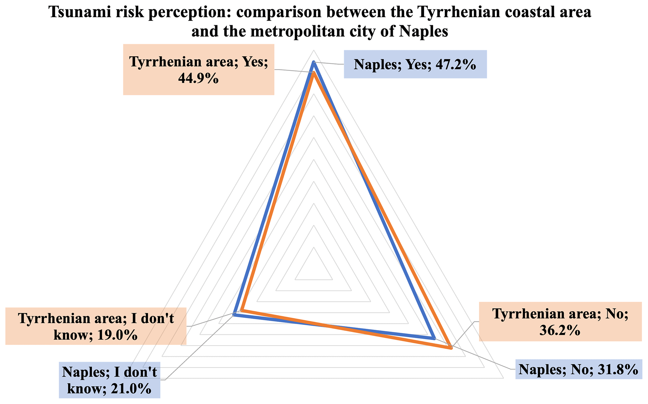
Figure 8Tsunami risk perception (Q16): comparison between the Tyrrhenian coastal area and the metropolitan city of Naples.
These data are consistent with the seaside average, and they diverge from the starting hypothesis.
These data could be related to multi-hazard variables that lead the municipalities' residents to express a greater risk perception due to the presence of the Vesuvius volcano, the seismic memory of the 1980 Irpinia earthquake, and the frequent bradyseism and micro-earthquakes that occur in the Neapolitan area (i.e., in the Phlegraean Fields). Traces of these events are also found in the literature, such as the case of the tsunami in 1345 CE, documented by the famous Italian writer Francesco Petrarca in his Letters on Familiar Matters (Petrarca, 2005) and recently described in Rosi et al. (2019).
Moreover, the city of Naples and the coastal municipalities of its hinterland have high exposure due to civil settlements and industrial complexes including some major-accident-hazard industries (Tinti and Armigliato, 2003; DePippo et al., 2008; Grezio et al., 2012) that are located on the coast. Last but not least, the metropolitan city of Naples has one of the highest coastal population densities in Europe, with concentrations ranging between 500 and 2500 inhabitants km−2 (ISTAT, 2020b).
The average risk perception for the metropolitan city of Bari is low (Fig. 9), in line with the Adriatic coast. In fact, we observe that only 34.3 % of respondents believe that a tsunami could hit their municipality, versus 32.4 % of those residing in municipalities on the Adriatic coast. We also observe that 54.4 % of respondents say a tsunami could not hit their coastal municipality, compared to 57.4 % for the average of those living in coastal municipalities in the same seaside area.
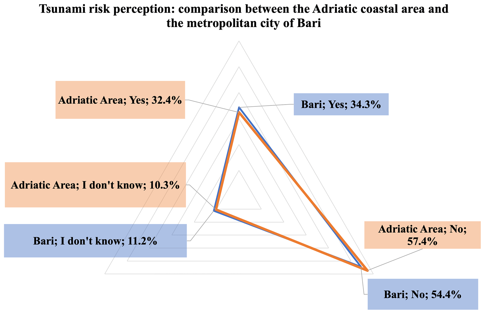
Figure 9Tsunami risk perception (Q16): comparison between the Adriatic coastal area and the metropolitan city of Bari.
The perception results appear to be low compared with the estimated hazard for the southern Adriatic coast and Bari metropolitan city, which is medium–high (Basili et al., 2021). The estimated hazard takes into account the strong earthquakes occurring along the Hellenic arc, able to generate tsunamis that would hit the Adriatic coasts including Bari. The low tsunami risk perception may also be influenced by the absence of recent tsunami events (Maramai et al., 2019) as already noted in Cerase et al. (2019).
The tsunami risk perception in the metropolitan city of Reggio Calabria is on average high (Fig. 10). The graph shows that 70.9 % of respondents believe that the city may be hit by a tsunami compared to the average of 46.5 % of respondents living in the Ionian sides' remaining municipalities and 45 % of those living in the Tyrrhenian sides' municipalities. Furthermore, data analysis shows that only 8.9 % of respondents answered “I don't know” to the specific question. This percentage could indicate that residents of the metropolitan city of Reggio Calabria have a greater tsunami risk knowledge of their area, compared to the other metropolitan cities considered in the analysis. The high tsunami risk perception is likely related to the 1908 tsunami, which had a strong impact on the territory, causing widespread damage and about 2000 casualties (attributed to the tsunami), and still holds a high media echo today and is still in residents' memories. The same regions were also struck by a tsunami in 1783 that, according to historical sources, caused about 1500 casualties (in addition to the over 25 000 caused by the earthquake) (Sarconi, 1784; Vivenzio, 1788; Boschi et al., 2000) and in 1905 when sea level changes were also recorded by tide gauges in Naples and Civitavecchia (about 500 km away).

Figure 10Tsunami risk perception (Q16): comparison between the Tyrrhenian and Ionian coastal area and the metropolitan city of Reggio Calabria.
In addition, Reggio Calabria residents' tsunami risk perception is in line with the high tsunami hazard estimated for the area (Basili et al., 2021).
The tsunami risk perception in the metropolitan city of Catania (Fig. 11) is slightly higher (49.7 %) than the risk perception of respondents of the Ionian coastal area (45.8 %). Only 11.6 % of the respondents answered “I don't know”, in line with the responses from the other coastal-area municipalities. The percentage of tsunami risk perception in Catania is probably associated with the presence of easily recognized hazards (e.g., volcanic risk and ash management due to the close Etna volcano, frequent earthquake shaking). In addition, industrial complexes and refineries along the coast increase the exposed value and possibly the risk perception. Not least, the tsunami hazard (Basili et al., 2021) in the Catania area is quite high, due to both local and distant tsunamis.
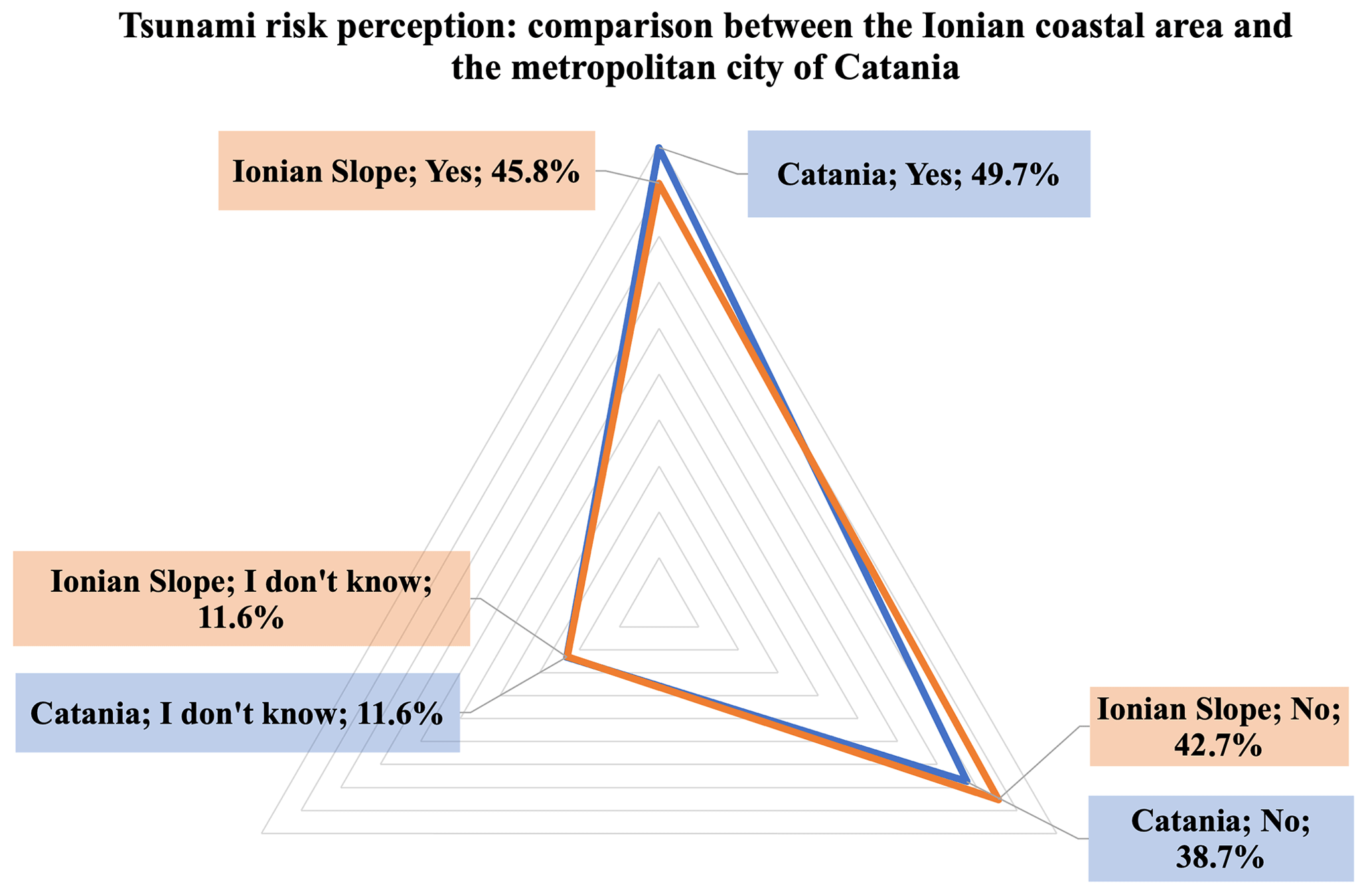
Figure 11Tsunami risk perception (Q16): comparison between the Ionian coastal area and the metropolitan city of Catania.

Figure 12Tsunami risk perception (Q16): comparison between the metropolitan cities (“yes” answer percentages).
Comparison among metropolitan cities (Fig. 12) shows a higher tsunami risk perception in Reggio Calabria, Catania, and Naples. These cities, throughout history, have been repeatedly affected by disruptive natural events including strong earthquakes, volcanic eruptions, and tsunamis. The difference in risk perception between metropolitan areas and coastal areas remains the subject of further study. The metropolitan city of Bari has a low tsunami risk perception even though it is located on a stretch of coastline where tsunami hazard is considered medium–high. This could be associated with events that occurred in the distant past and the low frequency of earthquake occurrence.
4.1.3 Tsunami risk perception: comparison with a national sample
In this section, we compare the tsunami risk perception for events in the Mediterranean area (surveyed in Q13) among the whole coastal population described above, and a national population sample (national sample survey n = 1500). From the graph (Fig. 13), it can be seen that risk perception is higher in coastal communities (39.4 %, CATI survey) and lower for the national average (19.2 %, national sample survey). Minor variations can be observed in the other response modes. A difference of 13 % also emerges in the central mode “neither likely nor unlikely” from which low tsunami knowledge is assumed.
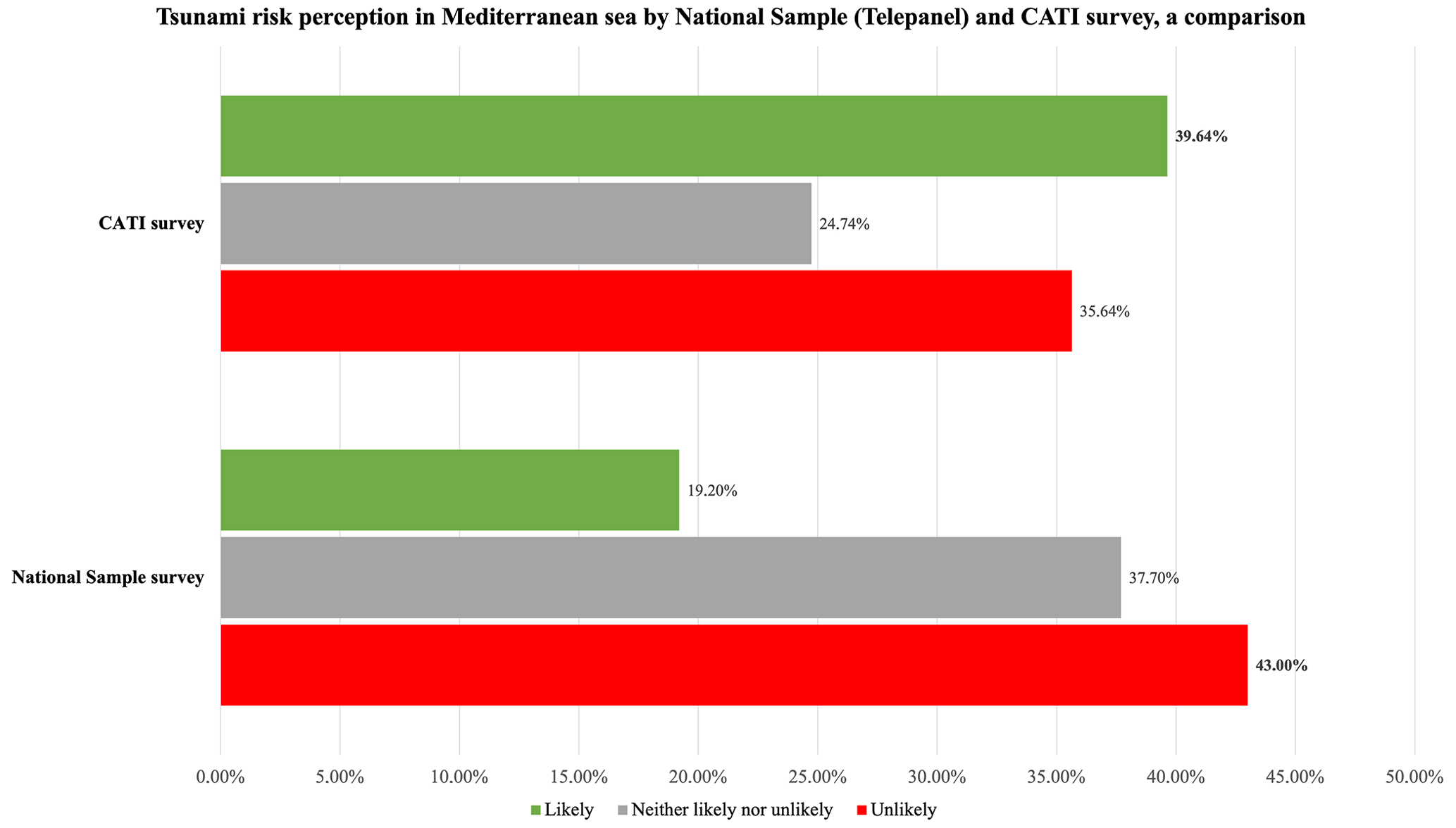
Figure 13Tsunami risk perception in Mediterranean Sea by the national sample and CATI surveys, a comparison.
The national sample survey also becomes of primary relevance to investigate the risk perception of the population not living in coastal areas who might face this risk in a summer vacation context even in non-national territories. Moreover, these data can be considered representative of the national mean related to the tsunami risk perception and may be used for comparison with data related to the same specific groups of population living on the coasts.
This result is not surprising, considering the lower familiarity of non-coastal inhabitants with sea activities – and hazards – compared to coastal-city residents. Also, we should consider that the tsunami risk for people spending for instance a 2-week vacation in a seaside location is statistically much lower compared to the risk to which a coastal resident is exposed. We anticipate that this result strongly suggests the need for a communication effort specifically oriented to tourists.
4.2 Tsunami knowledge
4.2.1 Phenomenon description: elicitation of the terms tsunami and maremoto
In order to explore people's understanding of tsunamis, we considered qualitative attributes to be relevant indicators of the phenomena of mental representation and related effects. The first step aims to explore the differences between the Japanese word “tsunami” (literally harbor wave), broadly used in the international scientific community, and the word “maremoto” (literally seaquake), which is a common alternative in colloquial Italian language. The overall results of this research confirm the different meanings attributed to these two terms by respondents.

Figure 14 shows that the largest part of the sample shows greater familiarity with the term tsunami (57 %), while maremoto drops by several percentage points (43 %). The word tsunami seems to sound more familiar for those who have higher education levels (66 %) and are below 65 years old. Some interesting differences regarding the usefulness of the two terms are related to local characteristics and will be further investigated. For example, in the metropolitan city of Reggio Calabria interviewees generally use the term maremoto to identify the phenomenon (57 %), whereas in Naples the term tsunami is more familiar (63 %).
We could hypothesize that past events differently shape the way the phenomenon is acknowledged and understood, as culture provides different resources to address these events, where traditional environmental knowledge plays a prominent role along with scientific communication. These aspects are reflected in social representations (Moscovici, 1961) as well as in language being used to express such representations (Moscovici, 1976).
Data in Fig. 14 show that the word tsunami is mostly associated with “big wave” (56 %), “earthquake” (54 %), and “sea storm” (34 %) and in a more detached position “inundation” (26 %), “flooding” (16 %), and “sea withdrawal” (13 %). Instead, the word maremoto is first associated with “earthquake” (57 %) and then with “sea storm” (40 %) and “big wave” (37 %). The terms “inundation” (23 %) and “flooding” (18 %) are still present along with “rough sea” (17 %).
4.2.2 Knowledge about causes of tsunamis
With regard to the alleged causes of tsunamis, they are generally attributed correctly to earthquakes, 74 % as the main cause, and then to volcanic eruptions (44 %), in agreement with the most frequent tsunami causes worldwide (NCEI/WDS, 2017); in the Mediterranean (Maramai et al., 2014); and in Italy, where 68 % of observed or recorded tsunamis were caused by earthquakes and about 16 % by volcanoes (Vesuvius and volcanoes of the Aeolian Islands) (Maramai et al., 2021).
In general, it is observed that tsunami knowledge is not directly related to gender and interviewee distribution but directly increases with educational degree and decreases with age (young, highly educated people under 50 years old are best informed).
Tsunamis are also associated by respondents with meteorological phenomena. In general terms this is somehow overestimated, but we know that meteotsunamis are rather frequent in the Mediterranean, especially in the Adriatic Sea (Šepić et al., 2009; Vilibić and Šepić, 2009; Maramai et al., 2022). However, it is possible that people confuse sea storms with (meteo)tsunamis. To verify this, we carried out a bivariate analysis that can provide some clues regarding this belief. Indeed, data highlight higher percentages for those who live in municipalities overlooking the Sea of Sardinia and the Sardinian Channel, both frequently swept by strong mistral winds, which can locally cause sea storms with waves several meters high.
We also note that weather conditions are most frequently mentioned by people with low education levels (22 %) versus 15 % of the sample with a high educational level.
Furthermore, landslides are properly indicated as possibly causing tsunamis by 14.8 % of respondents, as well as meteorites and space objects. A similar question, about tsunami risk perception induced by rock landslides, was asked in a survey conducted in Norway during the ASTARTE project by Goeldner-Gianella et al. (2017). In Norway, respondents correctly show high tsunami risk perception induced by rock landslides. This result is mainly due to the frequency of rock collapses occurring locally and to citizens' trust in local institutions for how tsunami risk is managed and how information is disseminated (Goeldner-Gianella et al., 2017).
4.2.3 Knowledge about tsunami effects
Knowledge about tsunami effects is investigated by Q22 (“Try to figure out the effects of a tsunami on the coasts of your region. How far do you agree with the following statements?”). Results show that in general, people are well aware of the possible worst effects of tsunamis on the coasts of their region. In particular, deaths and serious injuries are recalled by 93.9 % of the sample; damage to houses, buildings, and infrastructures by 93.1 %; and negative impacts on economy and on occupation and economy are both indicated by 89.4 %. It is worth saying that despite high rates of knowledge about possible tsunami impacts, women, most educated people, and people aged up to 65 years – as well as the inhabitants of the municipalities included in the area hit by the 1908 Strait of Messina tsunami – show slightly higher percentages. Summarizing, these kinds of effects are well known and evident to interviewees.
The data also show a catastrophic representation of tsunami effects that does not correspond to the expected effects on the Italian coasts where moderate-sized tsunamis are more likely to occur. This scenario probably comes from the diffusion of the catastrophic images of the tsunamis that occurred in Sumatra–Andaman in 2004 and in Tōhoku, Japan, in 2011, widely conveyed by television and social media. Given that macro-effects of a tsunami are well recognized and understood, smaller effects at the local and individual level seem to appear unfamiliar to respondents.
Indeed, data show that large coastal flooding is acknowledged by 83 % of the interviewed and sea withdrawal by 77 %, and the possibility that a small tsunami might drag an adult into the sea is known by 75 % (Q23). Only 24 % of respondents think that fleeing to the beach after a strong earthquake is appropriate behavior. The question about the possibility that a large tsunami with waves of up to 20 m may occur in the Mediterranean Sea raises some concerns, as only 46 % of the overall sample considers it a real possibility. Cross-tables highlight some unexpected surprises, such as higher rates of youngsters (31 %) and women (27 %) who consider fleeing to the beach a proper response to a massive earthquake.
4.2.4 Data on source information
Data on the sources of information being used by the interviewees provide a relevant framework to address and improve tsunami risk communication. As with our previous paper (Cerase et al. 2019), we have decided to group different sources into homogeneous categories. Data provide a clear indication of the central role of television, which is indicated as an information source by almost 90 % of the sample. In more detail, television news reaches 83 % of respondents and documentaries or scientific channels reach 23 %. Other traditional broadcast media, considered a unique category including newspapers, books, radio, and movies, are found to reach 58 % of the public. Considering disaggregate penetration rates, newspapers were mentioned by 35 %, books by 19 %, movies by 12 %, and finally radio by 8 %. Surprisingly enough, all internet sources show a penetration rate of about 18 % and interpersonal sources such as friends, relatives, and neighbors 5 %.
As noticed in the first step of the research, the impact of institutional and scientific sources appears to be a problematic issue, making urgent the development of a proper and effective risk communication strategy, since their overall penetration rate is a mere 3.5 %. In more detail, rates are about 2 % for civil protection; 1.6 % for universities and research institutions; and barely 1 % for local administrative entities such as those of the region, the province, and the municipalities. The residual category, other, was mentioned by only 35 people, corresponding to 0.6 %. This suggests that a strong effort is needed for institutional parties to fill this gap, through widespread and comprehensive dissemination of information (including information on evacuation routes and procedures) by using state-of-the-art communication channels.
Of course, data deserve further analysis by means of data reduction procedures, aimed at aggregating variables into new indicators and producing synthetic, more effective understanding of the considered phenomena.
The three surveys on tsunami risk perception, conducted between 2018 and 2021, started from the necessity to study and understand the level of knowledge of tsunami risk and the awareness of Italian citizens living in or visiting coastal areas exposed to tsunami hazard.
To date, these surveys represent a relevant sample of the Italian population, both for the number of interviewees and for the adopted methodology (5842 CATI interviews carried out on over 6000 km of coastline with moderate to very high tsunami hazard, plus a nationwide “Telepanel” sample representative of the whole Italian population).
The main results show that the tsunami risk perception varies significantly according to the coastal region. In particular, regions in the Adriatic (Apulia, Molise) show very low levels of risk perception compared to Calabria, Sicily, and Campania, on both the Ionian and the Tyrrhenian seaside. Latium and Sardinia lie in the middle, with equal numbers of people thinking that a tsunami could hit their region.
The educational degree affects tsunami risk perception: the higher the educational degree, the higher the tsunami risk perception.
On the contrary, data analyses show that tsunami risk perception is not influenced by either gender or age. A slight difference is observed in the middle age group in which interviewees of 35–49 years appear to have a slightly higher perception. Elderly people show the lowest frequency percentage in the response modality “I don't know” associated with low tsunami risk perception.
These data are consistent with several studies on local cultures, showing how communities that have previously experienced disasters are more likely to develop better resilience to and preparedness (Dekens, 2007) for these calamitous events. Such knowledge, which differs from scientific knowledge (Flavier et al., 1995), is associated with the historical memory of past experiences learned and transmitted through rituals, traditions, narratives, and folk songs (e.g., smong songs on the island of Simeulue) (McAdoo et al., 2006; Rahman et al., 2017, 2018; Sutton et al., 2021) and defined in a different way to “local knowledge”, “traditional knowledge”, “indigenous technical knowledge”, “peasant knowledge”, “traditional environmental knowledge”, and “folk knowledge” (Sillitoe, 1998; Mercer et al., 2007, 2010).
Memories of previous disasters both inform people's knowledge of their environment and vulnerability and influence their risk interpretation and response to future disasters (Arunotai, 2008). Collective memory, relying on oral tradition shared by a specific group, most commonly the family, tends to disappear with the death of the last eyewitness to the event (the three-generation limit). Cultural memory, supported by documents (such as newspapers, archives, images) and memorials as tangible signs for the community, ensures that disaster meanings and interpretations are recorded and transmitted from generation to generation. These forms of cultural memory, considered by Mercer et al. (2010) an existing or acquired knowledge set by local communities, are born and maintained through the accumulation of experiences, social relations, and community practices and institutions and their transmission across generations.
The study of Garnier and Lahournat (2022) highlights how Japanese stone monuments, representing elements of both tangible and intangible culture for the population, demonstrate the existence of disaster memory and reflect a desire to commemorate and transmit significant past events to current and future generations. These findings highlight the importance of oral transmission between generations regarding tsunami risk and could be very useful for designing effective information and communications activities about tsunami risk reduction (Spahn et al., 2010; Løvholt et al., 2014; Oktari et al., 2018; Sutton et al., 2020).
In this work, we also carried out a comparative analysis on tsunami risk perception between metropolitan areas and their respective coasts (see Sect. 4.1.1), starting from the hypothesis that risk perception could be different among the population residing in a large city and the population of small municipalities distributed along the seaside. The territorial units analyzed were selected based on exposure (higher coastal population density or proximity of major urban settlements to the coast) and territorial vulnerability (high concentration of anthropogenic activities such as industries or intensive tourism activities) according to ISTAT (Italian National Institute of Statistics) data.
The goal of this comparison is both to highlight possible differences in perceptions associated with densely populated urban areas and to provide a solid basis for targeted risk mitigation actions in specific contexts (for example to improve and better address the UNESCO Tsunami Ready program; Valbonesi et al., 2019, 2021; Valbonesi, 2022).
The results indicate that in Reggio Calabria, Catania, and Naples there are indeed significant differences in tsunami risk perception compared to in the respective seaside areas. These data are most evident in Reggio Calabria (71 %) with a difference of over 25 percentage points compared to the Tyrrhenian (45 %) and Ionian (46 %) sides of the same region (Calabria).
The data continue to be significant, albeit less evidently, for Catania (50 %) and the Ionian seaside (46 %) and for the city of Naples (47 %) and the Tyrrhenian seaside (45 %). It is useful to underline that the metropolitan city of Bari, despite being on a stretch of coast considered to be at high risk, has significantly lower values of perception of the tsunami risk (34 %), in line with the data for the whole Adriatic coast (32 %). Tsunami risk perception in the metropolitan area of Rome seems to be lower than on the Tyrrhenian coast. This is probably because Rome cannot really be considered a coastal town because most of its over 3 million inhabitants live far from the sea. The presence within the metropolitan area of Rome of the town of Ostia, a very populous municipality (over 231 000 inhabitants) lying along the Tyrrhenian coast, is not enough to raise the overall risk perception of the capital. It would be interesting to deepen this aspect with specific analysis of the local residents, commuters, and visitors. Given the city's proximity to the coast (about 20 km), it is also worth considering the large daily (as well as seasonal) tourist flows of the summer period.
The Telepanel data (n = 1500), collected in the same time period as the third survey, deserve particular attention because they provide a representative sample of the population at the national level, which means people predominantly living far from the seaside. Comparing the tsunami risk perception of the Telepanel with the surveys carried out on the coastal population, it emerges that the coastal population on average has a perception of risk significantly higher than the national average of about 20 percentage points. These data suggest that it is necessary to pay particular attention to the coastal touristic areas where every year millions of people spend their holidays. Providing information panels along the beaches and in the harbors, indicating evacuation routes and meeting points and establishing redundant alarm systems are the main tools to be put in place to reduce the tsunami risk of both residents and tourists.
As for knowledge of tsunamis, we started by considering the different associations linked to the two terms that are commonly used in the Italian language: tsunami and maremoto.
Results indicate that most of the sample is more familiar with the term tsunami (57 %), particularly those with a higher level of education (66 %), and the term is less familiar to people over 65 years old.
However, there are some differences that appear to be linked to local characteristics and which will be the subject of further investigation.
It is interesting to notice that the two terms are associated with different phenomena. For instance, the term tsunami is mostly related to the occurrence of a great destructive wave, while the word maremoto is more often related to the occurrence of an earthquake.
As for knowledge of the causes that generate tsunamis, in general the sample correctly attributes the occurrence of a tsunami to earthquakes and secondarily to volcanic eruptions, in line with scientific knowledge. Furthermore, tsunami knowledge does not seem to be linked to the gender and the areas of residence of the interviewees but increases according to their educational degree and inversely with age (people with a higher education degree and who are younger than 50 years old appear to be more informed).
Our data indicate that in general people are aware of the possible effects of tsunamis on their regions. However, this knowledge appears to be closely influenced by the media representation of the great tsunamis that occurred in Tōhoku, Japan (2011), and Sumatra–Andaman (2004). This type of media representation could turn out to be misleading with respect to the more modest phenomena that can be generated by smaller tsunamis, which are more frequently expected in the Italian coastal territory but are also capable of causing serious damage and creating victims.
However, the probability of a tsunami of significant size – such as the one that occurred in 1908 in southern Italy – is not entirely negligible.
Moreover, our data indicate that television continues to play a central role in conveying information relating to tsunami risk, while the information role played by social media and the web appears to still be marginal. A particularly problematic aspect concerns the poor visibility of scientific institutions and civil protection and local authorities in being recognized by the interviewees as official sources of information on the tsunami risk.
Our results suggest that the loss of memory of past events affects the perception of risk by citizens and communities, making risk mitigation actions more difficult and even ineffective (see for example Kurita et al., 2007; Sugimoto et al., 2010; Arias et al., 2017; Wei et al., 2017). Memory and recollections (such as commemorations of past events) are relevant for the development of risk mitigation strategies and to increase population resilience. More specifically, awareness raising aimed at attributing a sense and a meaning to the memory is needed in order to reduce risk. We believe that the results of this study, although limited to central and southern Italy, can be used in other countries of the NEAM region and worldwide to orient communication strategies and risk reduction actions.
In the near future, given the large number of data collected in the three surveys, we will focus on the creation of synthetic indexes for the perception and knowledge of tsunami risk.
We are also working to deepen knowledge related to cultural differences in the perception of risk, which seem to be very influenced by the local culture of reference. We are confident that this will allow us to better explain the differences in perception and knowledge that the data show in the different sea areas (coastal sides) and metropolitan cities. Finally, our efforts will be focused on translating the results of risk perception analyses into effective communication strategies for tsunami risk reduction. Not least, the 2018 pilot survey results – published in a previous paper by Cerase et al. (2019) – have already been extensively used in developing and improving the CAT website content. Moreover, several relevant aspects of the study made it possible to better address approaches in risk awareness campaigns such as “Io Non Rischio” (a civil protection campaign) as well as to undertake dissemination campaigns aimed both at raising awareness and at surveying tsunami risk perception in schools (one of the Tsunami Ready program indicators).
The research was carried out through the production of data with the CATI method and statistical analysis with dedicated software. Analyses were performed in SPSS Statistics, Version 26.0 (IBM Corp, Armonk, NY). The software requires a license fee and can be accessed online from the website: https://www.ibm.com/uk-en/products/spss-statistics (last access: 26 November 2022). The paper was written using the Microsoft Office suite. The software requires a paid license and can be accessed from: https://www.microsoft.com/en-gb (last access: 26 November 2022). No other type of code or software was used.
The dataset generated for the present study is not yet publicly available because the questionnaire has not yet been administered in all Italian coastal areas and the data are being further analyzed by the research team. However, data are available from the corresponding author on reasonable request.
The authors contributed to the different sections of this paper as follows: Introduction – LCu, MC, FLL, AC, AA, and LCe; Sect. 2 “Studies on tsunami risk perception, a brief overview” – LCu, MC, FLL, AC, AA, and LCe; Sect. 3 “CAT-INGV tsunami risk perception studies” – LCu, MC, FLL, AC, AA, and LCe; Sect. 3.1, “The tsunami risk perception questionnaire” – MC, FLL, and AC; Sect. 3.2 “Study area and sample characteristics” – MC, FLL, and AC; Sect. 3.3 “Sample validation for the three survey phases” – LCu and LCe; Sect. 3.4 “The national sample” – LCu and LCe; Sect. 4.1 “Tsunami risk perception” – LCu, MC, FLL, and LCe; Sect. 4.2 “Tsunami knowledge” – AC; Sect. 5 – LCu, MC, FLL, AC, AA, and LCe.
The contact author has declared that none of the authors has any competing interests.
This paper does not necessarily represent DPC's official opinion and policies.
Publisher’s note: Copernicus Publications remains neutral with regard to jurisdictional claims in published maps and institutional affiliations.
This article is part of the special issue “Tsunamis: from source processes to coastal hazard and warning”. It is not associated with a conference.
We thank the two anonymous reviewers and the editor Hélène Hébert for helpful suggestions that improved the manuscript. We thank Fabrizio Romano for his encouragement. This paper has benefited from the agreement between CAT-INGV and the Italian Presidenza del Consiglio dei Ministri, Department of Civil Protection (DPC).
This research has been supported by the National Department of Civil Protection (grant no. All. B2 2019/2021).
This paper was edited by Hélène Hébert and reviewed by two anonymous referees.
Akbar, Z., Suryaratri, R. D., Tri, Y., Gumelar, G., and Ariyani, M.: Disaster Risk Perception and Household Disaster Preparedness: Lesson Learned from Tsunami in Banten, in: IOP Conference Series: Earth and Environmental Science, IOP Publishing, 448, 012099, https://doi.org/10.1088/1755-1315/448/1/012099, 2020.
Alam, E.: Earthquake and tsunami knowledge, risk perception and preparedness in the SE Bangladesh, J. Geogr. Nat. Disasters, 6, 1–7, https://doi.org/10.4172/2167-0587.1000154, 2016.
Amato, A.: Some reflections on tsunami early warning systems and their impact, with a look at the NEAMTWS, Boll. Geofis. Teor. Appl., 61, 403–420, https://doi.org/10.4430/bgta0329, 2020.
Amato, A., Avallone, A., Basili, R., Bernardi, F., Brizuela, B., Graziani, L., Herrero, A., Lorenzino, M. C., Lorito, S., Mele, F. M., Michelini, A., Piatanesi, A., Pintore, S., Romano, F., Selva, J., Stramondo, S., Tonini, R., and Volpe, M.: From seismic monitoring to tsunami warning in the mediterranean sea, Seismol. Res. Lett., 92, 1796–1816, https://doi.org/10.1785/0220200437, 2021.
Apatu, E. J., Gregg, C. E., Wood, N. J., and Wang, L.: Household evacuation characteristics in American Samoa during the 2009 Samoa Islands tsunami, Disasters, 40, 779–798, https://doi.org/10.1111/disa.12170, 2016.
Arias, J. P., Bronfman, N. C., Cisternas, P. C., and Repetto, P. B.: Hazard proximity and risk perception of tsunamis in coastal cities: Are people able to identify their risk?, PLoS one, 12, e0186455, https://doi.org/10.1371/journal.pone.0186455, 2017.
Arunotai, N.: Saved by an old legend and a keen observation: The case of Moken sea nomads in Thailand, in: Indigenous Knowledge for Disaster Risk Reduction: Good Practices and Lessons Learnt from the Asia-Pacific Region, edited by: Shaw, R., Uy, N., and Baumwoll, J., UNISDR Asia and Pacific, Bangkok, 73–78, https://www.unisdr.org/files/3646_IndigenousKnowledgeDRR.pdf (last access: 26 November 2022), 2008.
Basili, R., Brizuela, B., Herrero, A., Iqbal, S., Lorito, S., Maesano, F. E., Murphy, S., Perfetti, P., Romano, F., Scala, A., Selva, J., Taroni, M., Thio, H. K., Tiberti, M. M., Tonini, R., Volpe, M., Glimsdal, S., Harbitz, C. B., Løvholt, F., Baptista, M. A., Carrilho, F., Matias, L. M., Omira, R., Babeyko, A., Hoechner, A., Gurbuz, M., Pekcan, O., Yalçıner, A., Canals, M., Lastras, G., Agalos, A., Papadopoulos, G., Triantafyllou, I., Benchekroun, S., Agrebi Jaouadi, H., Attafi, K., Ben Abdallah, S., Bouallegue, A., Hamdi, H., and Oueslati, F.: NEAMTHM18 Documentation: the making of the TSUMAPS-NEAM Tsunami Hazard Model 2018, Istituto Nazionale di Geofisica e Vulcanologia (INGV), Zenodo, https://doi.org/10.5281/zenodo.3406625, 2019.
Basili, R., Brizuela, B., Herrero, A., Iqbal, S., Lorito, S., Maesano, F. E., Murphy, S., Perfetti, P., Romano, F., Scala, A., Selva, J., Taroni, M., Tiberti, M. M., Thio, H. K., Tonini, R., Volpe, M., Glimsdal, S., Harbitz, C. B., Løvholt, F., Baptista, M. A., Carrilho, F., Matias, L. M., Omira, R., Babeyko, A., Hoechner, A., Gürbüz, M., Pekcan, O., Yalçıner, A., Canals, M., Lastras, G., Agalos, A., Papadopoulos, G., Triantafyllou, I., Benchekroun, S., Agrebi, Jaouadi, H., Ben Abdallah, S., Bouallegue, A., Hamdi, H., Oueslati, F., Amato, A., Armigliato, A., Behrens, J., Davies, G., Di Bucci, D., Dolce, M., Geist, E., Gonzalez Vida, J. M., González, M., Macías Sánchez, J., Meletti, C., Ozer Sozdinler, C., Pagani, M., Parsons, T., Polet, J., Power, W., Sørensen, M., and Zaytsev, A.: The Making of the NEAM Tsunami Hazard Model 2018 (NEAMTHM18), Front. Earth Sci., 8, 616594, https://doi.org/10.3389/feart.2020.616594, 2021.
Behrens, J., Løvholt, F., Jalayer, F., Lorito, S., Salgado-Gálvez, M. A., Sørensen, M., Abadie, S., Aguirre-Ayerbe, I., Aniel-Quiroga, I., Babeyko, A., Baiguera, M., Basili, R., Belliazzi, S., Grezio, A., Johnson, K., Murphy, S., Paris, R., Rafliana, I., De Risi, R., Rossetto, T., Selva, J., Taroni, M., Del Zoppo, M., Armigliato, A., Bureš, V., Cech, P., Cecioni, C., Christodoulides, P., Davies, G., Dias, F., Bayraktar, H. B., González, M., Gritsevich, M., Guillas, S., Harbitz, C. B., Kânoǧlu, U., Macías, J., Papadopoulos, G. A., Polet, J., Romano, F., Salamon, A., Scala, A., Stepinac, M., Tappin, D. R., Thio, H. K., Tonini, R., Triantafyllou, I., Ulrich, T., Varini, E., Volpe, M., and Vyhmeister, E.: Probabilistic tsunami hazard and risk analysis: a review of research gaps, Front. Earth Sci., 9, 628772, https://doi.org/10.3389/feart.2021.628772, 2021.
Bonaiuto, M., Alves, S., De Dominicis, S., and Petruccelli, I.: Place attachment and natural hazard risk: Research review and agenda, J. Environ. Psychol., 48, 33–53, https://doi.org/10.1016/j.jenvp.2016.07.007, 2016.
Boschi, E., Guidoboni, E., Ferrari, G., Mariotti, D., Valensise, G., and Gasperini, P.: Catalogue of Strong Italian Earthquakes from 461 BC to 1997, Appendix to volume 43, No. 4, 2000, Ann. Geophys.-Italy, 43, 609–868, 2000.
Brokensha, D. W., Warren, D. M., and Werner, O.: Indigenous knowledge systems and development, University Press of America, Washington D.C., ISBN 9780819111029, 1980.
Buylova, A., Chen, C., Cramer, L. A., Wang, H., and Cox, D. T.: Household risk perceptions and evacuation intentions in earthquake and tsunami in a Cascadia Subduction Zone, Int. J. Disast. Risk Re., 44, 101442, https://doi.org/10.1016/j.ijdrr.2019.101442, 2020.
Cerase, A., Crescimbene, M., La Longa, F., and Amato, A.: Tsunami risk perception in southern Italy: first evidence from a sample survey, Nat. Hazards Earth Syst. Sci., 19, 2887–2904, https://doi.org/10.5194/nhess-19-2887-2019, 2019.
Cirella, A., Romano, F., Avallone, A., Piatanesi, A., Briole, P., Ganas, A., Theodoulidis, N., Chousianitis, K., Volpe, M., Bozionellos, G., Selvaggi, G., and Lorito, S.: The 2018 Mw 6.8 Zakynthos (Ionian Sea, Greece) earthquake: Seismic source and local tsunami characterization, Geophys. J. Int., 221, 1043–1054, https://doi.org/10.1093/gji/ggaa053, 2020.
Cohen, E.: Tourism and land grab in the aftermath of the Indian Ocean tsunami, Scand. J. Hosp. Tour., 11, 224–236, https://doi.org/10.1080/15022250.2011.593359, 2011.
Collet, I. and Engelbert, A.: Eurostat: General and regional statistics, Catalogue number: KS-SF-13-030-EN-N, ISSN 2314-9647, http://ec.europa.eu/eurostat/statistics-explained/index.php/Archive:Coastal_regions_-_population_statistics (last access: 26 November 2022), 2013.
Cronbach, L. J.: Coefficient alpha and the internal structure of tests, Psychometrika, 16, 297–334, https://doi.org/10.1007/BF02310555, 1951.
Cronbach, L. J.: Internal consistency of tests: Analyses old and new, Psychometrika, 53, 63–70, https://doi.org/10.1007/BF02294194, 1988.
Dawson, A. G., Lockett, P., and Shi, S.: Tsunami hazards in Europe, Environ. Int., 30, 577–585, https://doi.org/10.1016/j.envint.2003.10.005, 2004.
Dekens, J.: Local knowledge for disaster preparedness: A literature review, International Centre for Integrated Mountain Development (ICIMOD), Kathmandu, https://doi.org/10.53055/ICIMOD.474, 2007.
DePippo, T., Donadio, C., Pennetta, M., Petrosino, C., Terlizzi, F., and Valente, A.: Coastal hazard assessment and mapping in Northern Campania, Italy, Geomorphology, 97, 451–466, https://doi.org/10.1016/j.geomorph.2007.08.015, 2008.
Dogan, G. G., Annunziato, A., Papadopoulos, G. A., Guler, H. G., Yalciner, A. C., Cakir, T. E., Sozdinler, C. O., Ulutas, E., Arikawa, T., Suzen, M. L., Guler, I., Probst, P., Kânoğlu, U., and Synolakis, C.: The 20th July 2017 Bodrum–Kos Tsunami Field Survey, Pure Appl. Geophys., 176, 2925–2949, https://doi.org/10.1007/s00024-019-02151-1, 2019.
Dogan, G. G., Yalciner, A. C., Yuksel, Y., Ulutaş, E., Polat, O., Güler, I., Şahin, C., Tarih, A., and Kânoğlu, U.: The 30 October 2020 Aegean Sea Tsunami: Post-Event Field Survey Along Turkish Coast, Pure Appl. Geophys., 178, 785–812, https://doi.org/10.1007/s00024-021-02693-3, 2021.
Dogulu, N., Karanci, N., and Lavigne, F.: Review of the existing work on tsunami resilient communities and identification of key indicators and gaps, ASTARTE Deliverable, report, 9, https://doi.org/10.13140/RG.2.1.2412.5922, 2014.
Douglas, M. and Wildavsky, A.: How can we know the risks we face? Why risk selection is a social process 1, Risk Anal., 2, 49–58, https://doi.org/10.1111/j.1539-6924.1982.tb01365.x, 1982.
EMDAT: Natural Disasters: Number of deaths by type of natural disaster, Int. Disaster Database, Univ. Cathol. Louvain. Bruselas, Belgica, https://www.emdat.be/, (last access: 28 November 2022), 2019.
Fernando, J. L.: NGOs and production of indigenous knowledge under the condition of postmodernity, Ann. Am. Acad. Polit. S. S., 590, 54–72, https://doi.org/10.1177/0002716203258374, 2003.
Flavier, J. M., Jesus, A. D., and Navarro, C. S.: The regional program for the promotion of indigenous knowledge in Asia. The cultural dimension of development: indigenous knowledge systems, Intermediate Technology Publications, London, 479–487, ISBN 9781853392511, 1995.
Fraser, S. A., Doyle, E. E., Wright, K. C., Potter, S. H., McClure, J., Johnston, D. M., Leonard, G. S., Coomer, M. A., Becker, J. S., and Johal, S.: Tsunami response behaviour during and following two local-source earthquakes in Wellington, New Zealand, Int. J. Disast. Risk Re., 16, 123–133, https://doi.org/10.1016/j.ijdrr.2016.02.008, 2016.
Garnier, E. and Lahournat, F.: Japanese stone monuments and disaster memory–perspectives for DRR, Disaster Prev. Manag. Int. J., 31, 1–12, https://doi.org/10.1108/DPM-03-2021-0089, 2022.
Goeldner-Gianella, L., Grancher, D., Robertsen, Ø., Anselme, B., Brunstein, D., and Lavigne, F.: Perception of the risk of tsunami in a context of high-level risk assessment and management: the case of the fjord Lyngen in Norway, Geoenviron. Disasters, 4, 1–15, https://doi.org/10.1186/s40677-017-0068-y, 2017.
Gravina, T., Nicola, M., Luca, F., and Pierfrancesco, C.: Tsunami risk perception along the Tyrrhenian coasts of Southern Italy: the case of Marsili volcano, Nat. Hazards, 97, 437–454, https://doi.org/10.1007/s11069-019-03652-x, 2019.
Gregg, C. E., Houghton, B. F., Paton, D., Lachman, R., Lachman, J., Johnston, D. M., and Wongbusarakum, S.: Natural warning signs of tsunamis: human sensory experience and response to the 2004 great Sumatra earthquake and tsunami in Thailand, Earthq. Spectra, 22, 671–691, https://doi.org/10.1193/1.2206791, 2006.
Grezio, A., Gasparini, P., Marzocchi, W., Patera, A., and Tinti, S.: Tsunami risk assessments in Messina, Sicily – Italy, Nat. Hazards Earth Syst. Sci., 12, 151–163, https://doi.org/10.5194/nhess-12-151-2012, 2012.
Ho, M., Shaw, D., Shuyeu, L., and Yao-Chu, C.: How do disaster characteristics influence risk perception?, Risk Anal., 28, 635–643, https://doi.org/10.1111/j.1539-6924.2008.01040.x, 2008.
ISTAT: Rapporto annuale 2020, La situazione del paese, Report, https://www.istat.it/it/archivio/244848 (last access: 4 July 2022), 2020a.
ISTAT: Rapporto sul territorio, 2020, Ambiente, Economia e Società, Report, https://doi.org/10.1481/Istat.RapportoTerritorio.2020, 2020b.
ISTAT: Demografia in cifre, ISTAT, Rome, Italy, ISBN 978-88-458-2066-3, 2021.
Jon, I., Lindell, M. K., Prater, C. S., Huang, S. K., Wu, H. C., Johnston, D. M., Becker, J. S., Shiroshita, H., Doyle, E. E. H., and Potter, S. H.: Behavioral Response in the Immediate Aftermath of Shaking: Earthquakes in Christchurch and Wellington, New Zealand, and Hitachi, Japan, Int. J. Env. Res. Pub. He., 13, 1137, https://doi.org/10.3390/ijerph13111137, 2006.
Kalligeris, N., Skanavis, V., Melis, N. S., Okal, E. A., Dimitroulia, A., Charalampakis, M., Lynett, P. J., and Synolakis, C. E.: The Mw = 6.6 earthquake and tsunami of south Crete on 2020 May 2, Geophys. J. Int., 230, 480–506, 2022.
Kurita, T., Arakida, M., and Colombage, S. R.: Regional characteristics of tsunami risk perception among the tsunami affected countries in the Indian Ocean, Journal of Natural Disaster Science, 29, 29–38, https://doi.org/10.2328/jnds.29.29, 2007.
Lindell, M. K. and Perry, R. W.: Household Adjustment to Earthquake Hazard: A Review of Research, Environ. Behav., 32, 461–501, https://doi.org/10.1177/00139160021972621, 2000.
Lindell, M. K., Prater, C. S., Gregg, C. E., Apatu, E., Huang, S. K., and Wu, H. C.: Households' immediate responses to the 2009 American Samoa Earthquake and Tsunami, Int. J. Disast. Risk Re., 12, 328–340, https://doi.org/10.1016/j.ijdrr.2015.03.003, 2015.
Lindell, M. K., Prater, C. S., Wu, H. C., Huang, S. K., Johnston, D. M., Becker, J. S., and Shiroshita, H.: Immediate behavioural responses to earthquakes in Christchurch, New Zealand, and Hitachi, Japan, Disasters, 40, 85–111, https://doi.org/10.1111/disa.12133, 2016.
Liu, Y., Yu, J., Yin, Q., Sun, C., and Sun, A.: Impacts of human factors on evacuation performance in university gymnasiums, Physica A, 582, 126236, https://doi.org/10.1016/j.physa.2021.126236, 2021.
Løvholt, F., Setiadi, N., Birkmann, J., Harbitz, C., Bach, C., Fernando, N., Kaiser, G., and Nadim, F.: Tsunami risk reduction – are we better prepared today than in 2004?, Int. J. Disast. Risk Re., 10, 127–142, https://doi.org/10.1016/j.ijdrr.2014.07.008, 2014.
Maramai, A., Brizuela, B., and Graziani, L.: The Euro-Mediterranean tsunami catalogue, Ann. Geophys.-Italy, 57, S0435, https://doi.org/10.4401/ag-6437, 2014.
Maramai A., Graziani L., and Brizuela B.: Italian Tsunami Effects Database (ITED), Istituto Nazionale di Geofisica e Vulcanologia (INGV), https://doi.org/10.13127/tsunami/ited.1.0, 2019.
Maramai, A., Graziani, L., and Brizuela, B.: Italian tsunami effects database (ITED): the first database of tsunami effects observed along the Italian coasts, Front. Earth Sci., 9, 596044, https://doi.org/10.3389/feart.2021.596044, 2021.
Maramai, A., Brizuela, B., and Graziani, L.: A Database for Tsunamis and Meteotsunamis in the Adriatic Sea, Appl. Sci., 12, 5577, https://doi.org/10.3390/app12115577, 2022.
Martin, W. E., Martin, I. M., and Kent, B.: The role of risk perceptions in the risk mitigation process: the case of wildfire in high risk communities, J. Environ. Manage., 91, 489–498, https://doi.org/10.1016/j.jenvman.2009.09.007, 2009.
Mauelshagen, F.: Flood disasters and political culture at the German North Sea coast: a long-term historical perspectiv, Hist. Soc. Res., 32, 133–144, https://doi.org/10.12759/hsr.32.2007.3.133-144, 2007.
McAdoo, B. G., Dengler, L., Prasetya, G., and Titov, V.: Smong: How an oral history saved thousands on Indonesia's Simeulue Island during the December 2004 and March 2005 tsunamis, Earthq. Spectra, 22, 661–669, https://doi.org/10.1193/1.2204966, 2006.
McIvor, O., Napoleon, A., and Dickie, K. M.: Language and culture as protective factors for at-risk communities, International Journal of Indigenous Health, 5, 6–25, https://doi.org/10.18357/ijih51200912327, 2009.
McNeill, I. M., Dunlop, P. D., Heath, J. B., Skinner, T. C., and Morrison, D. L.: Expecting the unexpected: Predicting physiological and psychological wildfire preparedness from perceived risk, responsibility, and obstacles, Risk Anal., 33, 1829–1843, https://doi.org/10.1111/risa.12037, 2013.
Mercer, J., Dominey-Howes, D., Kelman, I., and Lloyd, K.: The potential for combining indigenous and western knowledge in reducing vulnerability to environmental hazards in small island developing states, Environ. Hazards, 7, 245–256, https://doi.org/10.1016/j.envhaz.2006.11.001, 2007.
Mercer, J., Kelman, I., Taranis, L., and Suchet‐Pearson, S.: Framework for integrating indigenous and scientific knowledge for disaster risk reduction, Disasters, 34, 214–239, https://doi.org/10.1111/j.1467-7717.2009.01126.x, 2010.
Moscovici, S.: La psychoanalyse, son immage et son publique, Paris, PUF, https://doi.org/10.2307/3319763, 1961.
Moscovici, S.: Social influence and social change, London, Accademic Press, trad.it, Psicologia delle minoranze attive, Torino, Boringhieri, in Palmonari, A. (1995), Processi simbolici e dinamiche sociali, Bologna, Il Mulino, ISBN 0125084501, 1976.
Musacchio, G., Eva, E., Crescimbene, M., Pino, N. A., and Cugliari, L.: A protocol to communicate seismic risk in schools: design, test and assessment in Italy, Ann. Geophys.-Italy, 64, 1-22, https://doi.org/10.4401/ag-8533, 2021.
National Geophysical Data Center/World Data Service (NCEI/WDS): NCEI/WDS global historical tsunami database. National Oceanic and Atmospheric Administration, National Centers for Environmental Information, https://doi.org/10.7289/V5PN93H7, 2017.
Necmioğlu, Ö., Turhan, F., Özer Sözdinler, C., Yılmazer, M., Güneş, Y., Cambaz, M. D., Altuncu Poyraz, S., Ergün, T., Kalafat, D., and Özener, H.: KOERI's tsunami warning system in the eastern mediterranean and its connected seas: a decade of achievements and challenges, Appl. Sci., 11, 11247, https://doi.org/10.3390/app112311247, 2021.
Nunnally, J. C.: Psychometric theory – 25 years ago and now, Educ. Researcher, 4, 7–21, https://doi.org/10.3102/0013189X004010007, 1975.
Oktari, R. S., Shiwaku, K., Munadi, K., and Shaw, R.: Enhancing community resilience towards disaster: The contributing factors of school-community collaborative network in the tsunami affected area in Aceh, Int. J. Disast. Risk Re., 29, 3–12, https://doi.org/10.1016/j.ijdrr.2017.07.009, 2018.
Papadopoulos, G. A., Gràcia, E., Urgeles, R., Sallares, V., De Martini, P. C., Pantosti, D., González, M., Yalciner, A. C., Mascle, J., Sakellariou, D., Salamon, A, Tinti, S., Karastathis, V., Fokaefs, A., Camerlenghi, A., Novikova, T., and Papageorgiou, A.: Historical and pre-historical tsunamis in the Mediterranean and its connected seas: Geological signatures, generation mechanisms and coastal impacts, Mar. Geol., 354, 81–109, https://doi.org/10.1016/j.margeo.2014.04.014, 2014.
Paton, D., Sagala, S., Okada, N., Jang, L. J., Bürgelt, P. T., and Gregg, C. E.: Making sense of natural hazard mitigation: Personal, social and cultural influences, Environ. Hazards, 9, 183–196, https://doi.org/10.3763/ehaz.2010.0039, 2010.
Peterson, R.: A Meta-Analysis of Cronbach's Coefficient Alpha, J. Consum. Res., 21, 381–391, https://doi.org/10.1086/209405, 2014.
Petrarca, F.: Letters on Familiar Matters (Rerum Familiarium Libri): Vol. 1: Books I–VIII, translated by: Bernardo, A. S., Italica Press, New York, NY, https://doi.org/10.2307/j.ctt1tqxw4s, 2005.
Rafliana, I., Jalayer, F., Cerase, A., Cugliari, L., Baiguera, M., Salmanidou, D., Necmioğlu, Ö., Aguirre Ayerbe, I., Lorito, S., Fraser, S., Løvholt, F., Babeyko, A., Salgado-Gálvez, M. A., Selva, J., De Risi, R., Sørensen, M. B., Behrens, J., Aniel-Quiroga, I., Del Zoppo, M., Belliazzi, S., Pranantyo, I. R., Amato, A., and Hancilar, U.: Tsunami risk communication and management: Contemporary gaps and challenges, Int. J. Disast. Risk Re., 70, 1–30, https://doi.org/10.1016/j.ijdrr.2021.102771, 2022.
Rahman, A., Sakurai, A., and Munadi, K.: Indigenous knowledge management to enhance community resilience to tsunami risk: Lessons learned from Smong traditions in Simeulue island, Indonesia, in: IOP Conference series: earth and environmental science, IOP Publishing, 56, 012018, https://doi.org/10.1088/1755-1315/56/1/012018, 2017.
Rahman, A., Sakurai, A., and Munadi, K.: The analysis of the development of the Smong story on the 1907 and 2004 Indian Ocean tsunamis in strengthening the Simeulue island community's resilience, Int. J. Disast. Risk Re., 29, 13–23, https://doi.org/10.1016/j.ijdrr.2017.07.015, 2018.
Renn, O.: Public responses to the Chernobyl accident, J. Environ. Psychol., 10, 151–167, https://doi.org/10.1016/S0272-4944(05)80125-2, 1990.
Rippl, S.: Cultural theory and risk perception: a proposal for a better measurement, J. Risk Res., 5, 147–165, https://doi.org/10.1080/13669870110042598, 2002.
Ritchie, H. and Roser, M.: Natural Disasters. Our World in Data, BE J. Econo. Anal. Poli., 8, 1935–1682, https://ourworldindata.org/grapher/natural-disaster-death-rates?time=1900..2018&country=~All+natural+disasters (last access: 26 November 2022), 2014.
Rosi, M., Levi, S. T., Pistolesi, M., Bertagnini, A., Brunelli, D., Cannavò, V., Di Renzoni, A., Ferranti, F., Renzulli, A., and Yoon, D.: Geoarchaeological evidence of middle-age tsunamis at Stromboli and consequences for the tsunami hazard in the Southern Tyrrhenian Sea, Sci. Rep., 9, 1–10, https://doi.org/10.1038/s41598-018-37050-3, 2019.
Sarconi M.: Istoria de' fenomeni del tremuoto avvenuto nelle Calabrie e nel Valdemone nell'anno 1783, posta in luce dalla Reale Accademia delle Scienze e delle Belle Lettere di Napoli, edited by: Campo, G., Napoli, 197 pp., ISBN 8849813236, http://digital.casalini.it/8849813236 (last access: 26 November 2022), 1784 (in Italian).
Šepić, J., Vilibić, I., and Belušić, D.: Source of the 2007 Ist meteotsunami (Adriatic Sea), J. Geophys. Res.-Oceans, 114, 1–14, https://doi.org/10.1029/2008JC005092, 2009.
Sillitoe, P.: The development of indigenous knowledge: a new applied anthropology, Curr. Anthropol., 39, 223–252, https://doi.org/10.1086/204722, 1998.
Slovic, P.: Perception of risk, Science, 236, 280–285, https://doi.org/10.1126/science.3563507, 1987.
Slovic, P.: The risk game, J. Hazard. Mater., 86, 17–24, https://doi.org/10.1016/S0304-3894(01)00248-5, 2001.
Slovic, P. and Peters, E.: Risk perception and affect, Curr. Dir. Psychol. Sci., 15, 322–325, https://doi.org/10.1111/j.1467-8721.2006.00461.x, 2006.
Slovic, P., Fischhoff, B., and Lichtenstein, S.: Why study risk perception?, Risk Anal., 2, 83–93, https://doi.org/10.1111/j.1539-6924.1982.tb01369.x, 1982.
Soloviev, S. L., Solovieva, O. N., Go, C. N., Kim, K. S., and Shchetnikov, N. A.: Tsunamis in the Mediterranean Sea 2000 BC–2000 AD, Kluwer Academic Publishers, 237 pp., https://doi.org/10.1007/978-94-015-9510-0, 2000.
Sørensen, M. B., Spada, M., Babeyko, A., Wiemer, S., and Grünthal, G.: Probabilistic tsunami hazard in the Mediterranean Sea, J. Geophys. Res., 117, B01305, https://doi.org/10.1029/2010JB008169, 2012.
Spahn, H., Hoppe, M., Vidiarina, H. D., and Usdianto, B.: Experience from three years of local capacity development for tsunami early warning in Indonesia: challenges, lessons and the way ahead, Nat. Hazards Earth Syst. Sci., 10, 1411–1429, https://doi.org/10.5194/nhess-10-1411-2010, 2010.
Student: The probable error of a mean, Biometrika, 6, 1–25, https://doi.org/10.2307/2331554, 1908.
Sugimoto, M., Iemura, H., and Shaw, R.: Tsunami height poles and disaster awareness: Memory, education and awareness of disaster on the reconstruction for resilient city in Banda Aceh, Indonesia, Disaster Prev. Manag., 19, 527–540, https://doi.org/10.1108/09653561011091869, 2010.
Sun, Y., Yamori, K., Tanisawa, R., and Kondo, S.: Consciousness of disaster risk and tsunami evacuation: a questionnaire survey in Okitsu, Kochi Prefecture, Journal of Natural Disaster Science, 34, 127–141, https://doi.org/10.2328/jnds.34.127, 2013.
Sutton, S. A., Paton, D., Buergelt, P., Sagala, S., and Meilianda, E.: Sustaining a Transformative Disaster Risk Reduction Strategy: Grandmothers' Telling and Singing Tsunami Stories for over 100 Years Saving Lives on Simeulue Island, Int. J. Env. Res. Pub. He., 17, 7764, https://doi.org/10.3390/ijerph17217764, 2020.
Sutton, S. A., Paton, D., Buergelt, P., Sagala, S., and Meilianda, E.: Nandong Smong and Tsunami lullabies: Song and music as an effective communication tool in disaster risk reduction, Int. J. Disast. Risk Re., 65, 102527, https://doi.org/10.1016/j.ijdrr.2021.102527, 2021.
Tinti, S. and Armigliato, A.: The use of scenarios to evaluate the tsunami impact in southern Italy, Mar. Geol., 199, 221–243, https://doi.org/10.1016/S0025-3227(03)00192-0, 2003.
Triantafyllou, I., Gogou, M., Mavroulis, S., Lekkas, E., Papadopoulos, G. A., and Thravalos, M.: The Tsunami Caused by the 30 October 2020 Samos (Aegean Sea) Mw7.0 Earthquake: Hydrodynamic Features, Source Properties and Impact Assessment from Post-EventField Survey and Video Records, J. Mar. Sci. Eng., 9, 1–31, https://doi.org/10.3390/jmse9010068, 2021.
UNESCO-IOC (Intergovernmental Oceanographic Commission): 10 years of the north-Eastern Atlantic, the Mediterranean and connected seas Tsunami Warning and mitigation System (NEAMTWS): accomplishments and challenges in preparing for the next tsunami, IOC/INF-1340, 59 pp., https://unesdoc.unesco.org/ark:/48223/pf0000247393 (last access: 26 November 2022), 2017.
UNESCO-IOC: Tsunami Early Warning and Mitigation System in the North-Eastern Atlantic, the Mediterranean and Connected Seas (NEAMTWS) 2005–2020, https://unesdoc.unesco.org/ark:/48223/pf0000373791 (last access: 26 November 2022), 2020.
Valbonesi, C.: Tsunami Ready Programme in NEAM region: strategies, responsibilities and further advancements to protect communities from tsunamis, EGU General Assembly 2022, Vienna, Austria, 23–27 May 2022, EGU22-11876, https://doi.org/10.5194/egusphere-egu22-11876, 2022.
Valbonesi, C., Amato, A., and Cerase, A.: The INGV Tsunami Alert Centre: analysis of the responsibility profiles, procedures and risk communication issues, B. Geofis. Teor. Appl., 60, 359–374, https://doi.org/10.4430/bgta0252, 2019.
Valbonesi, C., Amato, A., and Cugliari, L.: Tsunami Ready in Italy: first steps, EGU General Assembly 2021, online, 19–30 April 2021, EGU21-12521, https://doi.org/10.5194/egusphere-egu21-12521, 2021.
Vilibić, I. and Šepić, J.: Destructive meteotsunamis along the eastern Adriatic coast: Overview, Phys. Chem. Earth A/B/C, 34, 904–917, https://doi.org/10.1016/j.pce.2009.08.004, 2009.
Vivenzio, G.: Historia dei tremuoti avvenuti nella provincia di Calabria ulteriore e nella città di Messina nell'anno 1783 e di quanto nelle Calabrie fu fatto per il suo risorgimento fino al 1787, preceduta da una Teoria, ed Istoria Generale de' Tremuoti, con un Atlante di 21 Tavole. Stamperia Regale, 2 voll., Napoli, ISBN 8864560920, 1788 (in Italian).
Wachinger, G., Renn, O., Begg, C., and Kuhlicke, C.: The risk perception paradox – implications for governance and communication of natural hazards, Risk Anal., 33, 1049–1065, https://doi.org/10.1111/j.1539-6924.2012.01942.x, 2013.
Wei, H. L., Wu, H. C., Lindell, M. K., Prater, C. S., Shiroshita, H., Johnston, D. M., and Becker, J. S.: Assessment of households' responses to the tsunami threat: A comparative study of Japan and New Zealand, Int. J. Disast. Risk Re., 25, 274—282, https://doi.org/10.1016/j.ijdrr.2017.09.011, 2017.
Wildavsky, A. and Dake, K.: Theories of risk perception: Who fears what and why?, Daedalus, 119, 41–60, http://www.jstor.org/stable/20025337 (last access: 26 November 2022), 1990.
Yalçıner, A., Annunziato, A., Papadopoulos, G., Güney-Doğan, G., Gökhan-Güler, H., ErayCakir, T., Özer-Sözdinler, C., Ulutaş, E., Arikawa, T., Süzen, L., Kanoğlu, U., Güler, I., Probst, P., and Synolakis, C.: The 20th July 2017 (22:31 UTC) Bodrum-Kos Earthquake and Tsunami: Post Tsunami Field Survey Report, http://www.emsc-csem.org (last access: 26 November 2022), 2017.
- Abstract
- Introduction
- Studies on tsunami risk perception, a brief overview
- CAT-INGV tsunami risk perception studies
- Results and discussion
- Discussion and concluding remarks
- Code availability
- Data availability
- Author contributions
- Competing interests
- Disclaimer
- Special issue statement
- Acknowledgements
- Financial support
- Review statement
- References