the Creative Commons Attribution 4.0 License.
the Creative Commons Attribution 4.0 License.
 | 14 Jun 2022
Risk communication during seismo-volcanic crises: the example of Mayotte, France
Robin Lacassin
Hugues Pécout
Geoffrey Robert
Population information is a fundamental issue for effective disaster risk reduction. As demonstrated by numerous past and present crises, implementing an effective communication strategy is, however, not a trivial matter. This paper draws lessons from the seismo-volcanic “crisis” that began in the French overseas department of Mayotte in May 2018 and is still ongoing today.
Mayotte's case study is interesting for several reasons: (i) although the seismo-volcanic phenomenon itself is associated with moderate impacts, it triggered a social crisis that risk managers themselves qualified as “a communication crisis”, (ii) risks are perceived mostly indirectly by the population, which poses specific challenges, in particular to scientists who are placed at the heart of the risk communication process, and (iii) no emergency planning or monitoring had ever been done in the department of Mayotte with respect to volcanic issues before May 2018, which means that the framing of monitoring and risk management, as well as the strategies adopted to share information with the public, has evolved significantly over time.
Our first contribution here is to document the gradual organization of the official response. Our second contribution is an attempt to understand what may have led to the reported “communication crisis”. To that end, we collect and analyze the written information delivered by the main actors of monitoring and risk management to the public over the last 3 years. Finally, we compare its volume, timing, and content with what is known of at-risk populations' information needs. Our results outline the importance of ensuring that communication is not overly technical, that it aims to inform rather than reassure, that it focuses on risk and not only on hazard, and that it provides clues to possible risk scenarios. We issue recommendations for improvement of public information about risks, in the future, in Mayotte but also elsewhere in contexts where comparable geo-crises may happen.
- Article
(3828 KB) - Full-text XML
-
Supplement
(6494 KB) - BibTeX
- EndNote


As recalled by the Sendai Framework for Disaster Risk Reduction, population information is a fundamental issue for effective disaster risk reduction (UNISDR, 2015, article 18.g.). Some researchers even consider that a disaster is a result of a crisis or a breakdown in the communication process (e.g., Gilbert, 1998). Implementing an effective communication strategy is, however, not a trivial matter. As pointed out by previous studies, and as exemplified by the current COVID-19 crisis, there are numerous pitfalls (see Lagadec, 1993; Lindell et al., 2006; or Rodríguez et al., 2007, for overviews). Deciding what content, format, and medium to use to share information is a first challenge. The information held by the actors in charge of risk management is often partial, sometimes contradictory, especially at the beginning of a crisis when there are many unknowns; the information available – and especially the information produced by scientists – can be difficult to translate into operational terms when there are large uncertainties; actors might also have difficulties in sharing information and/or in coordinating (see Doyle and Paton, 2018; Donovan et al., 2012; Donovan and Oppenheimer, 2012; Fearnley and Beaven, 2018, for applications on volcanic risks). Reaching the population at-risk is a next challenge. Traditional channels (press releases, public conferences, mass media) may allow a majority of people to be reached but might not help reaching minorities whose habits, customs, and sometimes day-to-day language differ (Lindell and Perry, 2004). Moreover, it is not enough for a message to reach people; it must then be understood, believed, and confirmed to have a chance to induce the expected response (e.g., Mileti and Sorensen, 1990; Mileti, 1999; Lindell and Perry, 2004). This implicitly raises the issue of trust and of the perceived credibility and legitimacy of information providers (see Haynes et al., 2008, for a reflection on the importance of trust in the management of volcanic risks).
The present paper contributes to the effort made by social sciences to build knowledge on risk communication processes. It draws lessons from the seismo-volcanic “crisis” that began in the French overseas department of Mayotte in May 2018 and is still ongoing at the time of writing. It focuses on “public information”, i.e., on the information shared by the actors in charge of monitoring and risk management with the public. The corresponding processes are sometimes called “external” communication processes, “internal” communication referring to the exchanges taking place between the actors (e.g., Becker et al., 2017).
Mayotte's case study is interesting because, although the seismo-volcanic phenomenon itself has been associated with moderate impacts (see Sect. 2), it triggered a social crisis that the risk managers themselves qualified as “a communication crisis” (see Sect. 3). The situation has eased in part nowadays, but scientists and authorities are still regularly taken to task, especially on social media (see Sect. 5). Mayotte's case study is also interesting because, with the exception of felt seismicity, deep-sea dead fishes occasionally found by fishermen, and gas bubbling in a few spots on land, risks are perceived mostly indirectly by the population at risk. As Skotnes et al. (2021) point out, risk and crisis communication about “invisible” hazards pose specific challenges. While trust is a key factor in communication in general, it becomes all the more crucial when one must rely entirely on the knowledge and experience of others to make decisions. The seismo-volcanic phenomena at stake here are not, strictly speaking, “invisible” (not in the sense of chemical or radiological pollution for instance), but everything one knows about it comes from scientific observation and interpretation. This puts scientists at the heart of the risk communication processes. Public information emerges thus in Mayotte, more than ever, as an end product of a complex interface between science, policy, and society. Decrypting this interface's mechanisms and dynamics is necessary to help actors, including scientists, better understand their role and its limits1.
Scientists and authorities have complementary roles to play with respect to population information. The local and national authorities are in charge of informing populations at risk about the nature and evolution of the threat and about the measures put in place to manage or reduce it. Scientists have a key role to play in helping the other stakeholders of the “risk chain”, including the at-risk population and the wider public, to comprehend scientific information as the latter is often too technical for non-specialists (e.g., Newhall, 1999; Fearnley and Beaven, 2018). This role is essential to maintain the legitimacy and credibility of the information on which public decisions are based, scientists being generally more trusted than their official counterparts (e.g., Eiser et al., 2009, on the predictors of trust and Donovan, 2021, for an overview of the challenges faced by experts in crisis contexts).
In Mayotte, as far as seismo-volcanic risk is concerned, a disaster has not yet occurred – the seismic crisis, although worrying for the population, has not caused significant damage. Yet many questions remain unanswered concerning the potential effects of the current activity in the short or medium term (see Sect. 2). Today's challenges are therefore those of scientific research to understand, monitoring to alert, and prevention and preparedness to reduce potential impacts, improve emergency management, and foster individual and collective resilience. As a recent report commissioned by the French ministry in charge of risk management (ministère de la transition écologique et solidaire) reminds us, the involvement of the population is crucial for the success of the process as a whole (Courant et al., 2021). There are, however, several indications that Mayotte's inhabitants have not been satisfied with the way information has been shared about the current event (see Sect. 3), although, as we will demonstrate later on, there has been a persistent effort by risk managers and monitoring experts to share information with the public. The issue hence arises of understanding what may have led to the reported “communication crisis”. We propose here to compare the information delivered by the main actors of monitoring and risk management to Mayotte's inhabitants with what is known of at-risk populations' information needs.
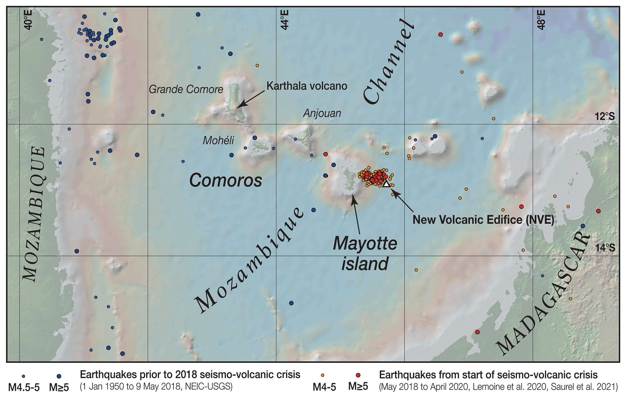
Figure 1Location of Mayotte, easternmost island of the Comoros archipelago. Blue dots: epicenters of seismic events prior to the seismic crisis that started on 10 May 2018 (magnitude ≥ 4.5, January 1950 to 9 May 2018, USGS catalog); red (magnitude ≥ 5) and orange (4 ≤ magnitude < 5) dots show earthquake epicenters with a well-constrained hypocentral depth from 10 May 2018 to April 2020 – locations from Lemoine et al. (2020) between May 2018 and March 2019 and REVOSIMA catalog between April 2019 and April 2020 (Saurel et al., 2021). Most earthquakes of the ongoing seismic crisis, as well as the new offshore volcanic edifice discovered in May 2019 (Feuillet et al., 2019, 2021a, b), are located 10–50 km east of Mayotte island. To avoid problems with mislocated events on this map we excluded epicenters with 10 km fixed depth and only plotted the ones with well-determined hypocentral depths. Topographic and bathymetric visualization is from GeoMapApp (http://www.geomapapp.org/, last access: 26 May 2022 – CC-BY).
First, we provide a brief overview of what is known about Mayotte's geological setting and the ongoing seismo-volcanic activity (Sect. 2). We then relate some elements of the political and social context that contributed to transform a telluric phenomenon of relatively minor consequence into a situation of crisis (Sect. 3). The corpus and methodology used in our analysis are described in Sect. 4. Section 5 describes the successive stages of organization of the monitoring and risk management response. As no emergency planning or monitoring had been done in the department of Mayotte with respect to volcanic issues before May 2018, the framing of the official response has evolved significantly over time. Documenting this evolution was a significant part of our work. It led us to distinguish four main phases (1–4) that are presented chronologically in Sect. 5. As public information strategies have not always evolved coincidently with monitoring and risk management frameworks, communication issues are discussed separately in Sect. 6. Analysis of the volume, timing, and content of the written documents used by authorities and scientists to share information with the public leads us to distinguish three main phases of communication (A–C). In Sect. 7, we discuss our results and issue recommendations to improve future communication strategies. We believe that the lessons learned from the relatively long-lasting case study of Mayotte (3 years), in a relatively unprecedented context (mostly submarine phenomena, leading to “invisible” risks, whose study requires significant resources and technical innovation), can usefully nourish the reflection carried out in the literature about risk communication and, more generally, disaster risk reduction.
Mayotte belongs to the Comoros archipelago, a chain of four main volcanic islands that extends approximately east–west between the east African coast and the northern tip of Madagascar (Fig. 1). Recent studies link the formation of these islands to an east–west zone of diffuse transtensional right-lateral shear at the immature boundary between the Somalia and Lwandle plates (e.g., Famin et al., 2020; Feuillet et al., 2021a; Tzevahirtzian et al., 2021). Following this interpretation, the Comoros volcanism occurs along en échelon northwest–southeast tensional fractures affecting the lithosphere in a context of northeast–southwest extension (Famin et al., 2020; Feuillet et al., 2021a). The location and genesis of this volcanism would be mostly due to lithospheric deformation (Michon, 2016; Famin et al., 2020; Feuillet et al., 2021a; Tzevahirtzian et al., 2021) rather than to a hotspot trail as previously proposed by several authors (e.g., Emerick and Duncan, 1982; Class et al., 2009). Volcanism and formation of the Comoros islands started at least ∼10 Myr ago (e.g., Emerick and Duncan, 1982; Michon, 2016). The Karthala volcano in the westernmost island of Grande Comore (Bachèlery et al., 2016) is still active today. It is monitored by the Karthala Observatory of the CNDRS (Centre National de Documentation et de Recherche Scientifique, in Moroni) in collaboration with the Institut de physique du globe de Paris and the University of La Réunion. In Mayotte, recent volcanism is documented with eruptive products as young as ∼4 kyr inland (e.g., Pelleter et al., 2014) and presently at the “new volcanic edifice” (NVE) discovered in May 2018 (Feuillet et al., 2021a). Recent analysis of seismic receiver functions by Dofal et al. (2021) points to a thinned continental crust beneath Mayotte with a former continental Moho at 17–19 km depth, underlined by a 9–10 km fast layer interpreted as resulting from magmatic underplating (Dofal et al., 2021). According to these authors, the magmatic reservoir feeding Mayotte's new volcanic edifice would be located below the interface between the underplated magmatic layer and the underlying mantle lithosphere.
The ongoing activity started on the night of 10 to 11 May 2018 with an earthquake of magnitude ML 4.3 felt by the population. Seismicity intensified on 15 May 2018 with several earthquakes of magnitude > 4, all largely felt, and an event of magnitude ML 5.8 (MW 5.9) (Lemoine et al., 2020). Although diminishing over time, seismic activity has continued since and is still active at the time of writing, >3.5 years after its beginning. Prior to May 2018, regional instrumental seismicity near the islands (blue dots in Fig. 1) was moderate, with the largest magnitudes recorded between 5 and 5.5 (Mb or MW according to USGS catalog).
In May 2018, Mayotte's area was poorly instrumented. The ability to identify and precisely locate the earthquakes improved gradually with the development of the network of seismic stations (Bertil et al., 2021; Saurel et al. 2021). The inclusion of underwater stations (OBS for ocean bottom seismometer) from February 2019 (Feuillet et al., 2021a; Saurel et al., 2021) and the use of refined seismic velocity models (Lavayssière et al., 2021; Saurel et al., 2021) were determinant in this respect. The study of the seismicity since the OBS deployment allowed the location of two clusters of seismicity: a dense “proximal cluster” located close to Mayotte's eastern coast and a “distal cluster” located about 30 to 40 km east of the islands extending eastward in the direction of the new volcanic edifice (Feuillet et al., 2021a; Saurel et al., 2021; Lavayssière et al., 2021). According to Lemoine et al. (2020), these two clusters have been active since the end of June 2018, while, from May to June 2018, the earthquakes occurred in a more distal cluster, shallower and closer to the new volcanic edifice. This earlier cluster would have included the large earthquakes that marked the beginning of the crisis. Distal clusters are interpreted to result from the fracturation and diking processes that allowed magma migration from the deep magma chamber to the new volcanic edifice (e.g., Cesca et al., 2020; Lemoine et al., 2020; Feuillet et al., 2021a; Lavayssière et al., 2021). The proximal cluster is composed of deep (∼35–50 km) seismic events that might be linked to the deformation induced by a deflating deep reservoir (e.g., Feuillet et al., 2021a, b; Lavayssière et al., 2021). It also contains less deep events (20–35 km) that might be due to stress perturbations around a shallower (∼25 km) reservoir, as suggested by the location of very long-period seismic events (Feuillet et al., 2021a; Lavayssière et al., 2021). Being close to the islands, it is this proximal seismic cluster, and the magmatic processes related to it, and their uncertain evolution that present the real significant hazard.
Inhabitants have mainly experienced the ongoing activity through felt earthquakes. More than 20 earthquakes of magnitude 5+ were recorded during the first month of the crisis, from 10 May to mid-June 2018 (Bertil et al., 2021), while ∼1900 events with magnitudes > 3.5 happened during the first year (Cesca et al., 2020; Lemoine et al., 2020). About 140 of these earthquakes were reported as having been felt by the population in the LastQuake crowdsource-based information app of the Euro-Mediterranean Seismological Center (EMSC-CSEM, 2021). There was a sharp decrease in the number of felt earthquakes after June 2018, in line with the decrease in the number of instrumentally recorded earthquakes and of their average magnitude (e.g., Lemoine et al., 2020; Bertil et al., 2021). The EMSC-CSEM catalog reports only about four felt events per month until the end of 2018 and then a moderate recovery in the number of felt events between February and June 2019 (nine felt events per month on average) (the red curve in Fig. 3 summarizes this information).
Geoscientists are accustomed to speaking of seismo-volcanic “crises”, although the use of the term “crisis” is not always relevant to disaster risk management definitions. However, in the case of Mayotte, the observed activity did indeed give rise, at least in the first months, to a crisis situation that required the intervention of the authorities in charge of civil protection and crisis management. We relate here some elements of the political and social context that contributed to this.
3.1 A vulnerable territory
Mayotte, which became a French Department in 2011, is a particularly vulnerable territory. It is marked by great poverty and high social inequality (Roinsard, 2014). In a population of 256 000, 77 % live under the poverty line, over 30 % are unemployed, 48 % are foreign (and often undocumented), 30 % have no access to clean drinking water, and 4 in 10 live in informal housing (according to Insee, 2021, with data from 2017). Mayotte's multiculturalism is a wealth that proves difficult to manage when the situation requires informing the widest possible audience: 95 % of the population is Muslim (Ministère des Outre-Mer, 2016), 45 % are from the Comoros (INSEE, 2021), and, while French remains the official language, about 37 % of the population do not speak it (Données 2017 – INSEE, 2017). Oral culture is the dominant one, and the most commonly spoken languages are Shimaore and Shibushi. There is no real integration between the traditional culture of the villages and the more westernized culture of large cities (Lambek, 2018). According to Regnault (2011), “three quarters of the Mahorais – rural or, at least, still very attached to their village – live a culture other than the `westernized' culture of the cities” (translation by the authors). The relationship with state authorities is complicated by the island's colonial past but also by a sense of disappointment among the population, who expected more rapid changes to bring the island up to French standards after departmentalization (Roinsard, 2019). Since 2011, Mayotte has been regularly shaken by social crises. The most recent one, which brought the economy to a standstill for 2 months in the spring of 2018, was just ending as the first earthquakes began (Roinsard, 2019; Mori, 2021). Lastly, the absence in living memory of seismic and volcanic events in Mayotte meant that part of the inhabitants were relatively naïve about such risks (although people coming from the neighboring Comoros islands may have experienced previous seismic and volcanic crises as four eruptions occurred in 2005, 2006, and 2007; see Morin et al., 2016).
3.2 A recurring complaint about a lack of information
The intensity and duration of the initial seismic crisis surprised not only the population but also the authorities and scientists. On 16 May 2018, the director of the scientific institution locally in charge of seismic monitoring (the Bureau de recherche géologique et minière, BRGM2) qualified the activity as “exceptional beyond anything recorded in Mayotte” (AFP dispatch picked up by many media, e.g., Le Point, 2018, 16 May 2018). A few days later, the prefect of Mayotte3 talked about “an abnormal and persisting activity” (Le Journal de Mayotte, 2018a). A month later, in an interview given to the French national press, the director of BRGM Mayotte declared the following: “Unfortunately, we are in the unknown” (15 June, Le Figaro, 2018b).
Although the earthquakes were of moderate intensity, they affected vulnerable buildings, and their multiplication caused the appearance of cracks leading some municipalities to close schools (Sira et al., 2018). Local observers reported strong anxiety among inhabitants, many people leaving their houses to sleep outside (Mori, 2021; Fallou and Bossu, 2019; Fallou et al., 2020; it was also reported in our interviews). They also testified to a general feeling of confusion linked to the unfamiliar nature of the hazard and to a lack of information. A group of citizens created a Facebook feed called Signalement tremblement de terre de Mayotte (STTM), aimed at reporting felt events and at sharing experiences. The success of the feed, which soon gathered more than 10 000 members (about 4 % of the population), attested to the existing thirst for information. The posts exchanged at that time show a lack of confidence in the authorities' willingness to take charge of the situation: “Earthquakes that sometimes exceed magnitude 5, cracks in buildings, fires, landslides, etc. … and no real reaction from the state apart from information on the magnitude of the tremors already felt” (excerpt from STTM Facebook group, 26 May 2018); “How much do you want to bet that in a year nothing will have been done? As soon as the crisis passes we4 play the watch hoping that the next one will come when we leave the island. That's how the administration has managed Mayotte for decades” (excerpt from STTM Facebook group, 27 May 2018). On 5 June 2018, the deputy of Mayotte in the French national assembly warned the government about the consequences of a lack of public information leading to the spread of “false information fueled by fantasies that have the effect of increasing people's anxiety, generating a state of panic and even psychosis” (Ali, 2018). Eight months later, in February 2019, members of the STTM Facebook feed published an open letter urging the state, local elected representatives, and scientists to provide more information about the ongoing activity (Picard, 2019). Although this group is not really representative of the sociology or the demography of Mayotte's population, it soon became a serious interlocutor for the local authorities, and the prefect invited its most visible members to the discussion table in 2019 (YD, 2019). It remains today one of the public arenas where information about the seismo-volcanic crisis is followed with the most attention.
It took a whole year between the beginning of the seismic crisis and the official declaration, in an interministerial press release dated from 16 May 2019 (Ministère de la Transition écologique et solidaire, ministère de l'Enseignement supérieur, de la recherche et de l'innovation, ministère des Outre-mer, ministère de l'Intérieur, 2019), of the discovery of the new volcanic edifice. The event closed a year of questioning about the possible origin of the earthquakes. The unexpected “birth of a new volcano” (BBC – Science in Action, 2019) caused enthusiasm in the national and international scientific community, as well as in the media (e.g., Andrews, 2019; Minassian, 2019; Wei-Haas, 2019; Devès et al., 2022). The discovery has been described as “exceptional”: first, because of the large volume of lava involved, more than 5 km3 (Feuillet et al., 2021a) – corresponding to the largest eruption ever observed with modern techniques (Cesca et al., 2020; Feuillet et al., 2021a; Thordarson and Self, 1993) – and, second, because of the submarine nature of the activity – marking the beginning of an exciting scientific adventure to develop new techniques of observation. The local press welcomed this sudden interest in Mayotte's existence (Devès et al., 2022), the volcano being presented as a more positive way of talking about the 101st department than the usual references to its social misery (Le Journal de Mayotte, 2018c). But “discovering” the volcano is insufficient to characterize the associated threats. In this sense, the advance in knowledge showed itself to be frustrating for the inhabitants, for the authorities, and for journalists alike (Devès et al., 2022). In June 2019, STTM's Facebook feed members were still complaining about the official communication: “Say nothing, explain nothing … Can only create confusion … Questions that go around in circles because we don't have the answers! When there is neither answer nor explanation … One can only wonder … Why this? What interest or motivation do they have in not giving the information … They would like the population to worry: they couldn't do better! The sickly inability of administrations to communicate …” (excerpt from Facebook group STTM, 20 June 2019).
The present research is part of a research project entitled MAY'VOLCANO dedicated to the study of the circulation of knowledge between scientists, risk and crisis management actors, the media, and the population of Mayotte during the current seismo-volcanic crisis. This paper aims at providing a first analytical view of the public information process and of its potential limitations.
The empirical data for the research presented here were collected between 10 May 2018 and 1 April 2021, covering more or less the first 3 years of the ongoing seismo-volcanic “crisis”. The work was organized in three tasks: (1) documenting and understanding the organization of the monitoring and risk management response and its evolution over time, (2) documenting and understanding the organization of the process of public information and its evolution over time, and (3) examining the process of public information with regard to what is known of at-risk populations' information needs. The first two tasks were done in parallel. In the following, we describe the empirical data and the methods used to complete each of these tasks. The corresponding results are presented in Sect. 5 (task 1), Sect. 6 (task 2), and Sect. 7 (task 3).
4.1 Documenting and understanding the organization of the “official response” and its evolution over time
Our first task was to capture and understand the organization of the “official response”. By “official response”, we mean the decisions and actions taken by the local and national authorities in charge of risk and crisis management and by the scientific experts in charge of monitoring the ongoing seismo-volcanic activity. As emphasized in the “Introduction”, the framing of that response evolved significantly over time, and it was important to be able to document and describe these evolutions before addressing the issue of public information.
The methods chosen were participant observation, semi-structured interviews, and the collection and analysis of written archives. The fact that three of the authors worked at the Institut de physique du globe de Paris (IPGP), which is currently in charge of monitoring the activity, facilitated contact with experts. The involvement of the first author in previous research projects with crisis management officials facilitated contact with authorities.
Participant observation has been done within the framework of a day-to-day cohabitation with scientists at IPGP, within the scientific council of the REVOSIMA (réseau de surveillance volcanologique et sismologique de Mayotte), since February 2020 (when the first author was invited to join) and between January and June 2021 within a working group coordinated by the interministerial delegation for major risk reduction in overseas territories (the Délégation interministérielle aux risques majeurs en Outre-mer, DIRMOM), which developed an awareness-raising campaign (using videos) about the seismic and tsunami risks in Mayotte.
A total of 15 semi-structured interviews were conducted with the persons who were identified as pivotal to the overall monitoring and risk/crisis management process: eight with scientists directly involved in the organization of monitoring (sometimes at different moments of the crisis) and seven with risk or crisis managers acting at the local, national, or interministerial levels. Two of these persons were interviewed twice, before and after the creation of the REVOSIMA, which allowed us to gain a better insight into the associated changes. Most interviews were conducted via video conference because of the restrictions due to the COVID-19 pandemic. During the interviews, we asked questions about the actors involved in monitoring and risk and crisis management, about their role, and about the procedures, contents, and formats used to exchange information between themselves, with the media, and with the public. We also asked more specific questions about the communication process (see Sect. 4.2). All interviews were recorded (with the agreement of the interviewees) and transcribed soon after. The transcriptions were anonymized when used for discussion between the members of the team (only the first author has access to the original files as she was the one conducting the interviews). Citations taken from interviews for illustration in the present paper are anonymized to respect interviewees' confidentiality. We also provide our own English translation. The interviews were analyzed qualitatively with the aim to understand the organization of the official response and its evolution. The chosen method places emphasis on the meaning rather than the quantification of the materials.

Figure 2Diagram of the actors who played an active role in public information about the seismo-volcanic crisis of Mayotte during our period of study.
Regarding the collection of archives, we collected public press releases, public scientific bulletins, and official reports. Interviewees often spontaneously shared the materials they used to communicate and the materials on which they based their decision, such as internal notes and reports. We cite here only the documents that are public.
The work carried out on the basis of those data allowed us to identify the main actors to be considered for studying the process of public information (Fig. 2).
Two main categories of actors are distinguished according to their function: risk and crisis management or scientific monitoring.
On the risk and crisis management side, the main actors are (1) the prefecture of Mayotte, which is the body representing and implementing government policy at the local level, and (2) the ministries concerned with risk prevention (ministère de la transition écologique et solidaire), civil protection (ministère de l'intérieur), research (ministère de l'enseignement supérieur, de la recherche et de l'innovation), and overseas administration (ministère des Outre-mer). The interministerial level is also to be considered because of the active role played by a temporary interministerial delegation called DIRMOM (Délégation interministérielle aux risques majeurs en Outre-mer) whose task was to improve coordination between ministries on the topic of major risk reduction in the French overseas territories. The delegation was active between April 2019 and June 2021. The end of our study period therefore corresponds approximately to the end of DIRMOM's activity, at the dawn of a possible reorganization of interministerial coordination on major risk management overseas. In the French system, mayors are usually key actors in risk and crisis management. However, in the case of the seismo-volcanic crisis of Mayotte, it soon appeared that public information was mainly being orchestrated at the departmental and national levels (anonymous from interviews conducted in June 2020, April, June, and September 2021). The explanation that was given to us by interviewees is that the initial crisis overwhelmed the capacity of response of local mayors, requiring the intervention of the prefecture of Mayotte with support at the national level.
On the monitoring side, the number of actors involved has evolved significantly over time. In summary5, the Institut de physique du globe de Paris (IPGP), the School and Observatory of Earth Sciences in relation with the École et observatoire des sciences de la terre/Institut de physique du globe de Strasbourg (hereafter referred as EOST), the Bureau de recherche géologique et minière (BRGM), and the Institut français de recherche pour l'exploitation de la mer (IFREMER) have been directly involved in monitoring, although in different ways over time. They are the main partners in the REVOSIMA network. The latter, created in June 2019, is operated by the IPGP from its closest observatory in the Indian Ocean region, i.e., the Observatoire volcanologique du Piton de la fournaise (OVPF) on Réunion Island, and with the support of the antenna of BRGM in Mayotte. The Bureau central sismologique français – Réseau national de surveillance sismique (BCSF-RéNass), the European-Mediterranean Seismological Centre (EMSC), and the National Institute of Geographic and Forest Information (IGN) centralize, distribute, or provide data.
4.2 Documenting and understanding the organization of the process of public information and its evolution over time
The ultimate goal of this research being to examine the process of public information, it required documenting and understanding how the above-mentioned network of actors organized its “external” communication (Becker et al., 2017) and how it evolved with time. We used the same methods as those mentioned in Sect. 4.1. In addition to the questions listed earlier, we also asked the interviewees what the roles of the various actors were with respect to public information, what role they played at an individual scale, what the most important moments were for them with respect to public information, and what their view was on the effectiveness of that information regarding risk reduction. We also took note of the media most commonly used to share information with the public and decided to systematically collect the documents that were available (either online or with the help of the interviewees).
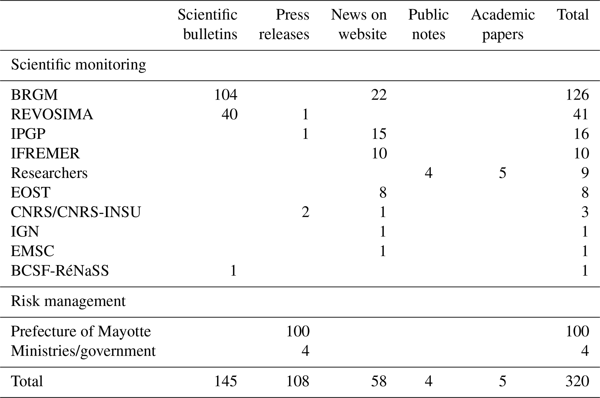
We searched the archives and in particular the web archives of the scientific and state institutions involved in monitoring and risk management. We collected all the written documents. By the end of our period of study, we had collected 320 items including press releases, scientific bulletins, news on websites and public notes (Table 1; a table listing all the documents we collected during our period of study is provided in the Supplement). Hereafter, we are citing scientific bulletins and websites as references (including their URL when available), while authorities' press releases are given in the dataset in the Supplement (press releases are typically from the prefecture of Mayotte, but there are also a few press releases from the government and from ministries). We did not consider the numerous automatic bulletins released by REVOSIMA (daily automatic bulletins have been released since March 2020), BCSF-RéNass, and EMSC, but we included the report published by the BCSF-RéNass's Groupe d'intervention macrosismique (GIM) and a web article from the EMSC aiming at providing a global view of the seismic crisis. We also included in our database the five academic papers (one was a preprint version of a submitted paper) dedicated to the crisis that were published during our period of study (Cesca et al., 2020; Famin et al., 2020; Feuillet et al., 2021b; Lemoine et al., 2020; Tzevahirtzian et al., 2021) and commented on by the press and/or the members of STTM Facebook group. We also took into account the contribution of individual researchers who issued key analyses at crucial times during the crisis (Briole, 2018).
Table 1Format and volume of the documents made public by the main actors of scientific monitoring and risk and crisis management during our period of study. A table listing all the documents we collected during our period of study is provided in the Supplement. As discussed in the text, we only count a report and a web article for, respectively, the BCSF-RéNass and the EMSC and not their automatic reports. We do not count the automatic bulletins from REVOSIMA. We include the five academic articles dedicated to the understanding of the phenomena occurring in Mayotte that were published during our study period.
Each item was downloaded, stored in pdf under a specific ID, and then read independently by two to three researchers who completed a table with information about format and content. Disagreements were discussed and solved collectively. We took note of the ID, the date of publication, the URL (when available), the publishing authors/institutions, the title, the public it was aimed at, the number of words, the presence or absence of illustrations, and the nature of these illustrations (scientific, local, etc.). We also took note of the main topics covered by the text and of the list of actors that were mentioned. This dataset was used to quantify the volume and timing of public information and to undertake a qualitative analysis of the content.
To complete our understanding of the public information process, we also explored Facebook publication feeds when they existed (i.e., for OVPF-IPGP, REVOSIMA, and prefecture of Mayotte) but without aiming for exhaustiveness as it was difficult to achieve without adequate tools.
Using the catalog of felt seismicity provided by EMSC (EMSC-CSEM, 2021), we compared the publication rate to the number of earthquakes felt by Mayotte citizens and its evolution in time (Figs. 3 and 4). This allowed us to put the scientists' and authorities' communication effort in perspective with the evolution of the geophysical signal that directly affected the population.
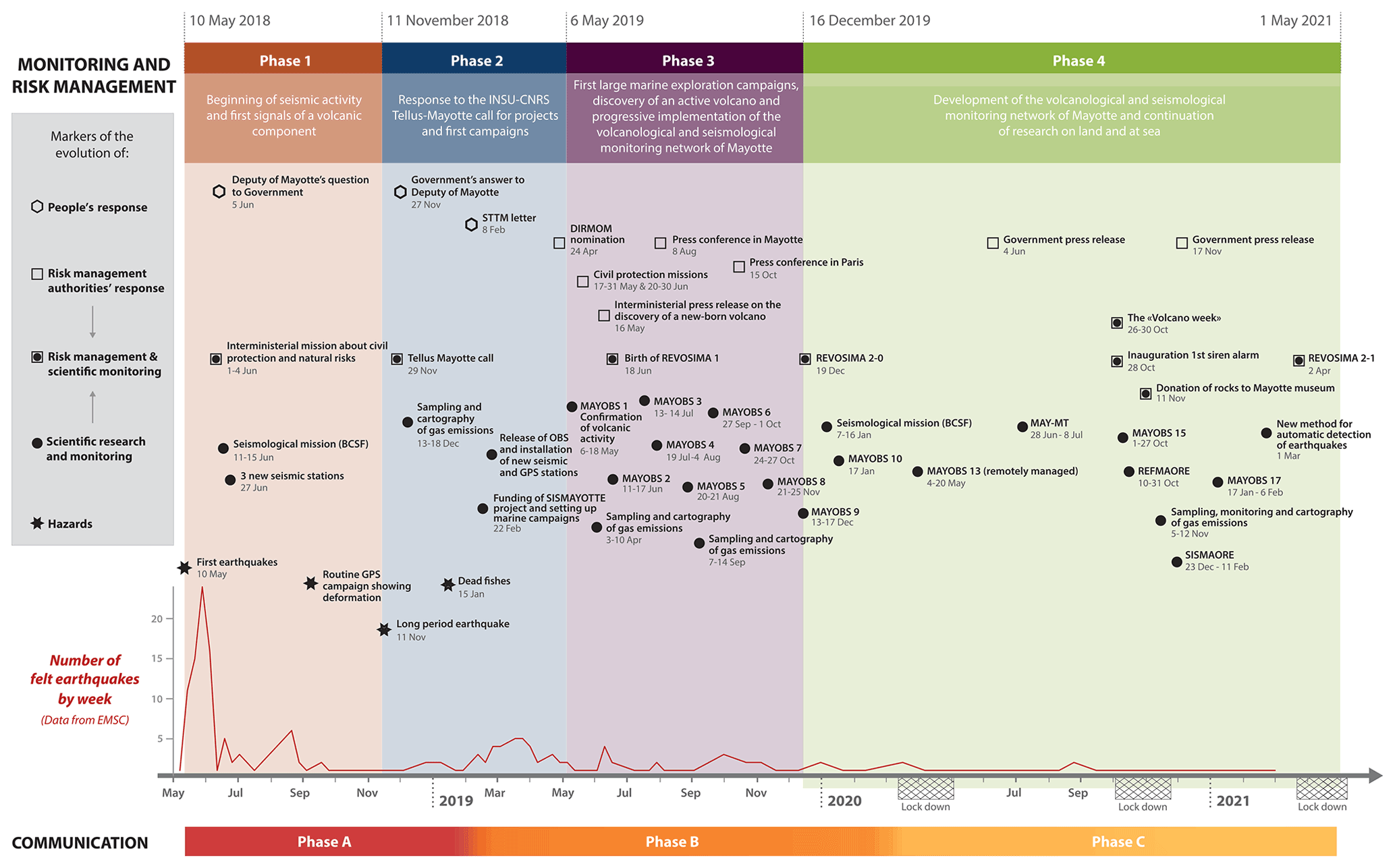
Figure 3Major phases and markers of the response by local and national authorities in charge of risk and crisis management and by scientific experts in charge of monitoring the seismo-volcanic activity in Mayotte. Our period of study extends from 10 May 2018 to 1 April 2021. SISMAYOTTE, REFMAORE, MAY-MT, and SISMAORE are acronyms of scientific campaigns. SISMAYOTTE was funded by “Tellus-Mayotte” and the others by REVOSIMA's institutional partners. The lockdown periods that are shown are those of metropolitan France (note that most of the scientific institutions involved in monitoring are located in metropolitan France). Mayotte endured longer lockdowns in spring 2020 and 2021, but there was no proper lockdown in autumn 2020.
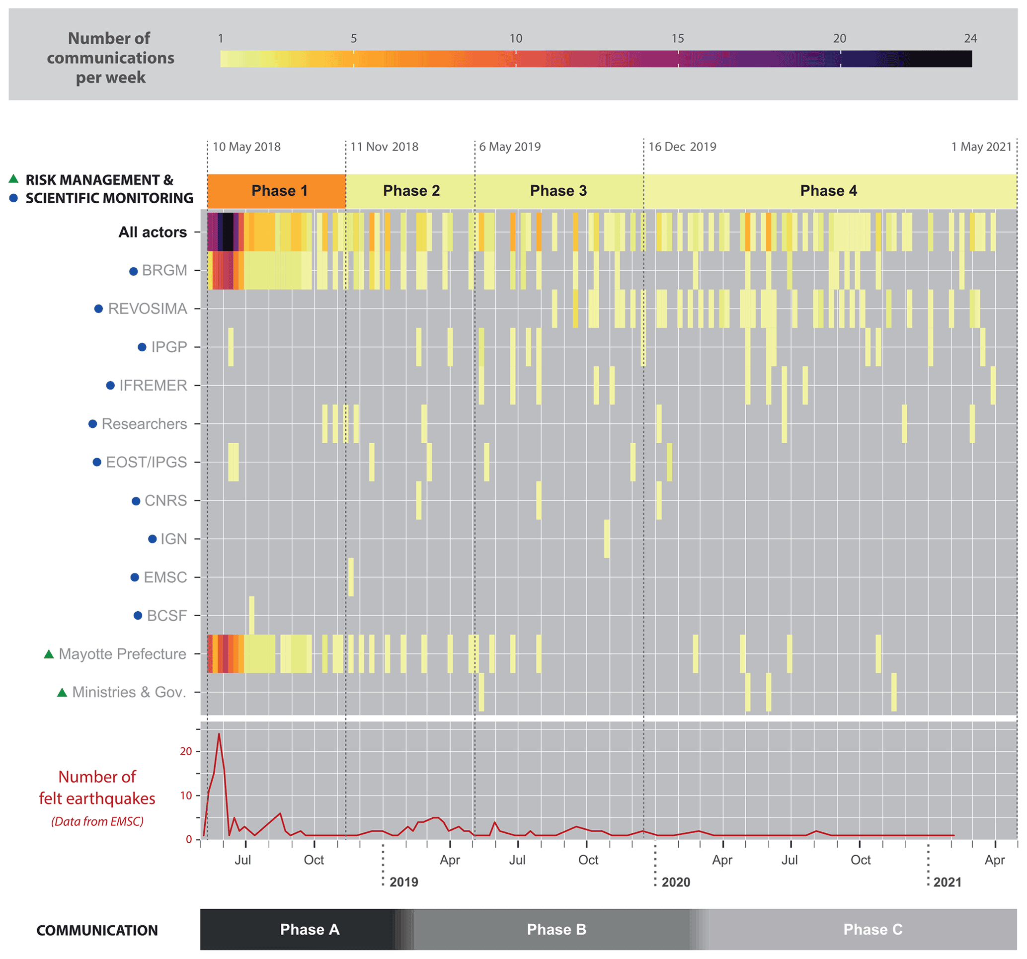
Figure 4Number of documents made public per week by the main actors of monitoring and risk and crisis management. The average number of documents published per day is indicated for each of the phases identified in Fig. 3.
4.3 Examining the process of public information with regard to what is known of at-risk populations' information needs
The combination of these data (archives, interviews, notes of participant observation, written documents used by the actors to share information with the public) provided the basis for examining the public information process with regard to what is known of at-risk populations' information needs. The latter is inferred from the existing literature on risk communication (which is abundant on this particular topic; see Sect. 7) while bearing in mind the social and cultural context of Mayotte.
We also explored STTM's Facebook publication feed but, again, without aiming for exhaustiveness as it was difficult to achieve without adequate tools. Hereafter, we use excerpts from STTM Facebook posts to illustrate some of our statements. We anonymized these citations and provide our own English translation (anonymized French original versions of the Facebook posts are given in the dataset in the Supplement).
As no emergency planning or monitoring had ever been done in the department of Mayotte with respect to volcanic issues before May 2018, the framing of the official response has evolved significantly over time. Here we provide a description of its gradual organization. We distinguish four main successive phases (1–4). The first phase goes from the recording of the first earthquakes to the recording of the first unambiguous signals of a volcanic component. The second phase corresponds to the mobilization of scientists, and funding agencies in relation to ministries, to get the financial means to instrument the area. The third phase runs from the first measurement campaigns to the proof of the volcanic activity which signaled the official setting up of the seismo-volcanic monitoring network of REVOSIMA. The fourth phase begins with the official creation of REVOSIMA and ends with our window of study. Figure 3 summarizes the key events that marked each of these four phases. In addition to the events linked to monitoring, we also discuss some key events in the response of scientists, authorities, and inhabitants of Mayotte.
5.1 Phase 1: 10 May to 10 November 2018
During the first phase of the crisis, the French Geological Bureau (BRGM) played a central role. It was the only geo-scientific institution with a permanent office in Mayotte, and, at the beginning of the seismic crisis, it was in charge of maintaining the only three accelerometric seismic stations installed on the island (known as moderately active). BRGM Mayotte was hence the natural interlocutor of the local and national authorities for decision support. However, the situation was difficult as crucial data were missing. Only the largest magnitude earthquakes (M>5) were reported by global seismic networks, while the existing local network – the few accelerometric stations in Mayotte completed by a few regional stations in Comoros and in Madagascar – did not allow a good record of the surge in moderate-magnitude earthquakes felt by the population. Because of this inadequate network, the BRGM operators initially encountered difficulties in accurately locating the earthquakes and assessing their epicentral depths (see Sect. 2).
In June 2018, the persistence of the seismic crisis led to the involvement of new actors. Ministries in charge of civil protection (ministère de l'intérieur) and disaster risk prevention (ministère de la transition écologique et solidaire) sent an interministerial mission composed of civil protection experts and seismologists (e.g., Mayotte la 1ère, 2018; Perzo, 2018b). The experts concluded that the impact of the earthquakes mainly resulted in an aggravation of disorders on buildings that were already vulnerable (widening, elongation of cracks) and reported that about 30 people got minor injuries that were indirectly linked with the earthquakes (e.g., falling down stairs to get out of the house). They also outlined that the repetition of shaking had been causing a feeling of anxiety and fear among the population, all the more marked as this seismic swarm phenomenon was unknown in Mayotte until then6. In mid-June 2018, a team of seismologists from BCSF-RéNass was sent to “estimate the levels of damage induced by this seismic swarm according to the vulnerability of the buildings at the date of the field analysis” (Sira et al., 2018). Three more seismic stations were installed (two short-period Raspberry Shake velocimeters by the BCSF and one broad-band velocimeter in the frame of the Sismo à l'école network). During the summer, scientists from IPGP and EOST helped the BRGM team to monitor the activity7. In July, the French scientific community started organizing to seek funding to instrument the area, notably at sea. A note was sent to the French National Centre for Scientific Research (CNRS) to attract funding agencies' attention to Mayotte's issues8.
In September, routine satellite measurements (using Global Navigation Satellite System, GNSS) led by the IGN revealed strong displacement anomalies affecting stations located on the island. Researchers from the École Normale Supérieure (ENS) geoscience lab analyzed the data, tracing the onset of surface deformation back to July 2018 (Briole, 2018). They explained it by the deflation of a huge magmatic chamber located off the coast of Mayotte. The lack of geological observations offshore Mayotte was still preventing a good understanding of the phenomenon, but the scientific community urged public authorities to fund geophysical instrumentation and surveys in the region.
5.2 Phase 2: 11 November 2018 to 5 May 2019
The second phase of the crisis started on 11 November 2018 with a long-period earthquake with peculiar characteristics (a very long trend of monochromatic seismic waves; e.g., Cesca et al., 2020; Lemoine et al. 2020). The event, not felt by the population because of its long-period character, was recorded by global seismic networks. It was much discussed on social networks and appeared to be mentioned in the international and soon national and local press (see discussion in Lacassin et al., 2020). It supported the volcanic hypothesis (Cesca et al., 2020; Lemoine et al., 2020). In mid-November, a meeting was organized with representatives of the four ministries, scientists, and scientific institutional stakeholders like CNRS-INSU. On 29 November, public authorities set up a call for projects to fund observation and research in the area. The call, named “Tellus-Mayotte”, was coordinated by the CNRS-INSU and co-financed by the ministry in charge of disaster risk prevention (ministère de la transition écologique et solidaire).
In January 2019, fishermen reported dead deep-sea fish at the surface of the ocean east of Mayotte (Perzo, 2019a)9. On 22 January, three projects were eventually selected on the Tellus-Mayotte call, involving 11 laboratories and 44 scientists from CNRS, IPGP, EOST, BRGM, Ifremer, and IGN. On 22 February, CNRS, IPGP, BRGM, and EOST announced the launch of the first major monitoring missions. Between February and March 2019, six OBSs were deployed at sea in the frame of these Tellus-Mayotte projects, and new seismic and GNSS stations were installed on land (by OVPF-IPGP, BRGM, EOST). A team from the University of La Réunion associated with OVPF-IPGP carried out field missions to consolidate knowledge of the tectonic and volcanic history of Mayotte.
5.3 Phase 3: 3 May to 5 December 2019
The third phase of the crisis started with the first MAYOBS (Mayotte Ocean Bottom Seismometers) marine campaigns on the scientific ship Marion Dufresne (MAYOBS 1 on 6–18 May 2019 and MAYOBS 2 on 11–17 June). The campaigns were led under the auspices of the CNRS and involved scientists from BRGM, IPGP, EOST, IFREMER, the University Clermont Auvergne, the University of La Rochelle with the support of IGN, the national center for space studies (Centre national d'études spatiales, CNES), and the hydrographic and oceanographic marine observation service (Service hydrographique et océanographique de la marine, SHOM). The OBSs deployed in February were retrieved, and new ones were released. The data allowed relocating the earthquakes and specifying the location of the seismic swarms (Deplus et al., 2019; Feuillet et al., 2019, 2021a; Jacques et al., 2019; Saurel et al., 2019). Scientists also acquired high-resolution marine geophysical data, studied the water column, and carried out rock dredging operations on the seafloor. Ongoing deep-sea volcanic activity was discovered with a new ∼800 m high underwater volcanic edifice, confirming the already suspected volcanic hypothesis. The discovery was announced by an official press release signed by four ministries (e.g., Ministère de la Transition écologique et solidaire, ministère de l'Enseignement supérieur de la recherche et de l'innovation, ministère des Outre-Mer, ministère de l'Intérieur, 2019) and relayed by the scientific institutions involved in the campaign on their websites.
Numerous other marine campaigns followed, which allowed the understanding of the phenomenon to be refined progressively (see Rinnert et al., 2022, https://doi.org/10.18142/291 to access the MAYOBS campaigns' reports). On 18 June 2019, an interministerial meeting set up a scientific and technical committee to monitor the activity and make official the creation of the Volcanological and Seismological Monitoring Network of Mayotte (REVOSIMA) with the implementation of “a monitoring of volcanological and seismological activity in real time and continuously” (IPGP, 2019b, published on 27 August 2019, translation by the authors). Several phases were envisaged for the implementation of this network. In a first phase, the REVOSIMA (called REVOSIMA 1 by the actors) was supported by a EUR 2.5 million fund in order to establish a monitoring network and to guarantee a scientific follow-up of the phenomenon with the implementation of new oceanic campaigns aimed at deploying and recovering OBSs. The monitoring mission was entrusted to the IPGP, which was already in charge of the other French volcanological and seismic observatories. IPGP decided to operate this network through the Observatoire volcanologique du Piton de la fournaise (OVFP-IPGP) in co-responsibility with the BRGM and its regional direction in Mayotte. The REVOSIMA's mandate was outlined as follows: to “(i) monitor the seismo-eruptive dynamics on land and at sea, in particular in connection with offshore campaigns and underwater instrumentation to monitor the possible migration of seismicity and volcanism, (ii) monitor marine deformation and submersion, (iii) characterize and monitor gravitational instabilities and tsunami hazard, (iv) improve knowledge of the tectonics and geodynamic context of Mayotte, [and] (v) monitor the geochemistry of volcanic fluids” (IPGP, 2019b, published on 27 August 2019, translation by the authors). In October 2019, a “pickathon” was organized by the REVOSIMA's scientists in order to speed up the process of seismicity relocation10.
5.4 Phase 4: 16 December 2019 to 1 April 2021
The fourth phase of the crisis corresponds to the progressive development of the volcanological and seismological monitoring network which facilitated the progress of research on land and at sea (there have been more than eight research and monitoring campaigns since December 2019). In December 2019, a new interministerial meeting ratified the perpetuation of the surveillance network and the release of EUR 4.5 million in funding. REVOSIMA 2 was launched at the beginning of 2020. In January 2020, seismologists of BCSF-RéNass came back to Mayotte to trace the evolution of damage due to the earthquakes from June 2018, and a second pickathon was organized to relocate seismicity. From March 2020 onwards, the scientific monitoring actors had to deal with disruptions due to the international pandemic of COVID-19. A double maritime campaign (MAYOBS 13-1, MAYOBS 13-2) was nevertheless organized in May with the support of the French Navy. The second campaign was remotely operated by scientists from IFREMER, IPGP, BRGM, and CNRS located in metropolitan France. It was followed, in June, by a magnetotelluric campaign (MAY-MT) and, in October, by a seismo-refraction campaign (REFMAORE), both coordinated by BRGM. The oceanographic campaigns have continued at a steady pace since then despite the second and third COVID-19 lockdowns. The only notable change, at the end of our study period, was the improvement of the automatic earthquake location method announced by REVOSIMA in March 2021.
Table 1 lists the preferred publication format and the volume of communication issued by the main actors in charge of monitoring and crisis and risk management during our period of study. Figure 4 shows that the number and frequency of publications have varied greatly over time and among actors. Public information was particularly intense during the first 6 weeks of the crisis and continued with some regularity throughout 2018. The average number of communications per day was 6.8 during the first phase of the crisis (phase 1), compared to 1.3 (phase 2), 1.2 (phase 3), and 1.0 (phase 4) during subsequent phases. Over 90 % of all press releases and scientific bulletins issued by authorities and scientists during our period of study are dated from 2018, i.e., during the period qualified by Fallou et al. (2020) as an “information vacuum”. This finding deserves an in-depth analysis to understand the discrepancy between the initial high communication rate and the perceived lack of information. Hence, hereafter, we analyze in detail not only the frequency but also the content and modalities of public information and its evolution over time. Three main phases are distinguished (A–C) that are discussed in relation to phases 1–4 describing the evolution of the monitoring and risk management response (Figs. 3 and 4).
6.1 Phase A: from the beginning of the crisis to February 2019
Between the beginning of the seismic crisis and February 2019, the modalities of communication did not vary much. The local stakeholders in charge of monitoring and risk and crisis management, BRGM and the prefecture of Mayotte, were the main contributors. Other scientific actors, such as the IPGP and the EOST who were gradually getting involved in monitoring from the first months of the crisis, were only communicating periodically to report on the geodynamic context of the activity and/or on their involvement in the collect and treatment of data: e.g., on 11 June 2018, EOST announced the dispatch of the macroseismic response mission (GIM) to Mayotte (EOST, 2018a); on 12 June, IPGP published an information brief on the ongoing crisis in Mayotte (IPGP, 2018).
The first communication to the public was a press release from the prefecture of Mayotte on 14 May 2018. Referring to the monitoring undertaken by the BRGM since 10 May 2018, it mentioned a “swarm of earthquakes”, distinguished it from seismic aftershocks, and recalled the safety instructions to be followed in case of earthquakes. Three press releases were published on 15 May that listed the time and magnitude of felt earthquakes and specified that “all the earthquakes [took] place in the same sector (around 50 km off Mayotte) and, although located at sea, [were] too weak to generate a tsunami”. Confronted with the repetition of felt earthquakes, the prefect of Mayotte activated a crisis unit on 16 May 2018. From then on, the prefecture published press releases on a daily basis (sometimes more), while the BRGM, switching to “crisis monitoring”, published daily reports11. As testified by several interviewees, during that first phase of the crisis, the local branch of BRGM was put under strong pressure “to be able to inform, almost `day and night', the authorities on the magnitude, on the location of the earthquakes, a more precise location than the one announced by the international networks which were not reliable because of their distance” (anonymous, interview in May 2020).
During the first weeks of the crisis, the scientific reports and official press releases followed one another within a few hours. BRGM published its bulletins on the BRGM website12, while the prefecture sent press releases to the press and published them on Facebook. These official press releases generally reproduced the elements communicated by the BRGM. They remained often very technical, recalling the number of earthquakes recorded per day, their magnitude, the time at which they were detected, and their distance from the island (the reports mentioned uncertainties of the order of 10–15 km). The prefecture's press releases could contain additional elements about impacts (injuries, building damage) and often recalled safety instructions. They also provided information about the decisions taken by the prefecture to support the inhabitants of the island (e.g., the setting up of a toll-free phone number and the opening of a psychological support unit; the demand for (and arrival of) a support mission of civil protection and risk management in June 2018).
In mid-June 2018, the BRGM published a frequently asked questions (FAQ) on its website explaining the state of knowledge and the main uncertainties. However, as written a few months later by the ministry in charge of civil protection (ministère de l'intérieur) in its answer to the deputy of Mayotte, “the most inventive explanations have found an echo in part of the population (conspiracy, actions of evil spirits, etc.) and communication is proving difficult. The state has obviously been concerned about this situation since the beginning of the event, and everything possible is being done to inform the population in a reliable manner” (Question à l'assemblée nationale no. 8992, 27 November 2018, Ali, 2018). Among the incorrect explanations that had emerged, a popular one was that the earthquakes were caused by oil exploration off the coast of Mayotte (Fallou et al., 2020; Mori, 2021). The hypothesis of a volcanic cause had also surfaced: it was discussed on the websites of national scientific laboratories (EOST, 2018b; IPGP, 2018) and in the local press (e.g., YD, 2018) as early as May–June 2018.
From the end of June 2018, the number of communications decreased with the decrease in seismic activity (two BRGM bulletins per week from 29 June 2018). In September 2018, BRGM announced that “the swarm [was] still running [but that] the lull observed since the end of June [justified] the change from `crisis' monitoring to `routine' monitoring” (bulletin of 17 September, BRGM, 2018a). From then on, BRGM published bulletins twice a month, with exceptional bulletins in the case of felt earthquakes. In October 2018, analyzing the routine GNSS measurements led by the IGN, a geophysicist from the École Normale Supérieure suggested that the seismicity could be related to the deflation of a deep magma chamber. These results were published in the form of notes on the public website of the laboratory in October, November, and December 2018 (Briole, 2018). In the opinion of several scientists we interviewed, the “wild” (sic) publication of his results played an important role in raising awareness of the importance of this seismic crisis among the scientific community and authorities in charge of risk management. On 7 November 2018, a press release from the prefecture of Mayotte mentioned that the IGN measured a shift of the island eastward, as well as a “slight downward shift”. The risk implications were not specified, but it was the first time the volcanological component was officially mentioned, 6 months after the hypothesis circulated among experts and in the press. The infrasound signal of 11 November 2018, whose occurrence supported the volcanic hypothesis, gave rise to intense discussions among the international scientific community (Lacassin et al., 2020). It was mentioned by the BRGM in a news item summarizing the current knowledge on the understanding of the ongoing activity published on its website on 17 December 2018 (BRGM, 2018b).
From January 2019, the frequency of BRGM bulletins continued to decrease to reach a frequency of one bulletin every 20–30 d.
6.2 Phase B: from February 2019 to February 2020
On 8 February 2019, following the initiative of the STTM group of Mayotte, 140 inhabitants of Mayotte signed an open letter addressed to the prefect of Mayotte, the local administration, the BRGM, and the local media. Pressing them for more information (Picard, 2019, on https://www.change.org/p/m-le-préfet-de-mayotte-plus-d-informations-et-de last access: 25 May 2022), they wrote: “You are not unaware that, for almost 9 months, a large majority of `your' population has been living in anxiety, incomprehension … Even anguish! The most `basic' questions about people's immediate risk exposition and safety remain unanswered … to say nothing of the long term! You are certainly convinced that you are doing the maximum so that the panic does not reach your `constituents'? BUT this is not the reality on the ground.” Expectations were particularly high toward scientists, who were expected to provide explanations and guidance with respect to risk scenarios, but in the absence of offshore observations the scientific advances were still poor.
February 2019 was an important tipping point, however, as the scientific community finally received the funding to work in the area. On 22 February 2019, CNRS issued a press release with the members of the Tellus-Mayotte call for tenders (CNRS, 2019). With the launch of the Tellus-Mayotte program, communication opened up to new scientific actors. IPGP and EOST announced their involvement in the up-coming missions on their website. BRGM scientists published the first public catalog of the seismic data collected since the beginning of the crisis (Bertil et al., 2018; Lemoine et al., 2019).
BRGM continued to publish a monthly bulletin dedicated to the monitoring of the seismicity, but communication from the prefecture of Mayotte became more episodic. It focused on relaying BRGM's situation points (with the list of events – among which the felt ones – in the past months) and on announcing the arrival of the Tellus-Mayotte scientific campaigns. The volcanic hypothesis was eventually put forward in the official communication. The press release of 3 April 2019 mentioned a “scientific volcanological mission” aiming at “consolidating knowledge of the tectonic and volcanic history of Mayotte and at highlighting the tectonic structures of the island by means of dating of magmatic rocks, or analyses of the composition of soil gases”.
One year after the beginning of the seismic crisis, it was time to take stock of the situation. In a press release published on 10 May 2019, the prefecture of Mayotte reviewed the actions undertaken, from both a scientific and risk management point of view, during the past year and concluded that “the latest data collected by the experts and the modeling of the phenomenon suggested a volcanic origin, possibly linked to a large-scale underwater eruption, or even to an origin combining both tectonic and volcanic phenomena”. When the scientists of the MAYOBS campaign arrived on the dock on 16 May 2019, they were accompanied by an interministerial press release (e.g., Ministère de la Transition écologique et solidaire, ministère de l'Enseignement supérieur, de la recherche et de l'innovation, ministère des Outre-Mer, ministère de l'Intérieur, 2019) announcing the discovery of a newborn volcano at the origin of the abnormal seismicity endured by the Mahorais for the past year. The government, through the voice of four of its ministries, committed to reinforce monitoring and prevention measures13. IPGP relayed the press release on its website on the very same day (IPGP, 2019a); IFREMER, EOST, and BRGM followed soon after. The announcement was relayed on Twitter, with a spectacular picture of the underwater volcanic edifice and the rising plume above it (Lacassin, 2019), which raised the interest of international scientists and of media such as National Geographic, Science, and the BBC (BBC – Science in Action, 2019; Pease, 2019; Wei-Haas, 2019). The prefecture and vice-rectorate of Mayotte launched a competition among primary and secondary schools to name the new-born volcano14.
There were similar surges in communication after the return of the next marine campaigns, MAYOBS 2 to 4, in June and July 2019 but much less communication afterwards15. The effort of communication resumed again in May 2020 after the MAYOBS 13 campaign.
From the discovery of the underwater volcanic activity, the prefecture of Mayotte and the BRGM were no longer the only two central actors regarding public information. On 28 May 2019, BRGM published its latest seismic bulletin on its own, and the prefecture of Mayotte published its latest press release only dedicated to the seismic crisis. Monitoring fell in the hand of the newly born REVOSIMA. Communication was then discussed at a more centralized level by the DIRMOM who reported directly to the cabinet of the prime minister. The prefecture worked closely with the DIRMOM to elaborate new communicational tools such as information leaflets. In early August, the prefect organized a press conference during which scientists presented the results of the last campaigns to elected officials and local dignitaries.
The creation of the REVOSIMA was eventually announced 1 year and 4 months after the start of the seismic “crisis” at the end of August 2019, during a visit from the minister of the overseas (ministère des Outre-mer) (Journal de Mayotte, 27 August 2019). The first web news concerning the creation of REVOSIMA was published on the IPGP website (IPGP, 2019b). Entitled “Volcanological and Seismological Monitoring Network of Mayotte”, it presented the mandate of the IPGP and its partners in monitoring the seismo-volcanic crisis in Mayotte. REVOSIMA issued its first scientific bulletins at the end of August 2019. Several bulletins were issued approximately at the same time (one bulletin for July and two for August 2019), creating the apparent surge in communication seen in Fig. 4. From then on, two scientific monitoring bulletins were published every month (it was reduced to one per month in March 2020)16.
A scientific conference was organized at IPGP in Paris on 15 October 2019. It aimed to present scientific advances and to discuss the challenges of its future monitoring. It was followed by a public conference and a question-and-answer session in the presence of state representatives and of the media. It was covered by national media, interested by the unprecedented nature of the activity (e.g., Vey, 2019), and the local press, proud to see a local scientist invited (Perzo, 2019b). In October 2019, the prefecture set up a “stakeholder committee”17 aimed at bringing together “all the notables, heads of department, politicians, around a table” and to whom scientists would be expected to present, about every 6 months, “the assessment of the crisis and the scientific findings” (anonymous, interview in May 2020). In November 2019, the prefecture organized public meetings in several municipalities of Mayotte but with a sparse audience (a few tens of people; anonymous, interview in May 2020).
In December 2019, the American Geophysical Union fall meeting hosted a special session dedicated to Mayotte's new volcano discovery in which the scientific results from the first MAYOBS campaigns were presented (e.g., Deplus et al., 2019; Feuillet et al., 2019; Jacques et al., 2019; Saurel et al., 2019). From our interviews, we understood that some tensions emerged between the authorities and the scientists about one of the poster communications (Poulain et al., 2019), which mentioned a delay of a few minutes between a triggering event due to the volcanic activity and the arrival of a tsunami on land. The authorities did not want such information to be communicated without having thought beforehand about the protection measures to be put in place. The decision was taken to not show the poster (interview in June 2020). At the end of 2019, EOST also announced the arrival of the second mission of the BCSF-RéNaSS macro-seismic intervention group in Mayotte. The continuation of REVOSIMA decided at the December 2019 interministerial meeting was not really announced, at least not publicly.
In January 2020, a team of French and German researchers, not members of REVOSIMA, published in Nature Geoscience the first academic paper analyzing the evolution in time of the seismicity and its relation with the ongoing volcanic activity (Cesca et al., 2020). This paper, mostly based on seismic data acquired by worldwide seismic networks, mentioned the discovery of the new volcanic edifice before its publication by the scientists directly involved in the survey campaigns and the close monitoring of the activity. The CNRS and the University of Toulouse, which hosted the second author of this paper, published a press release in French (CNRS and Université de Toulouse III, 2020) bearing a sketch section of the proposed magmatic plumbing system, which was commented on by the STTM group: “So much questions!!! In particular on the position of the magma chamber […] One or Two? 1 or 2 chambers? The island is moving east, towards the supposed chamber near the volcano??? And there's another one just below under the doormat on our front door”, “Silly question, but does that portend a big disaster for us?” (excerpts from STTM Facebook group, 8 January 2020).
In January, EOST also announced the results of the GIM mission and of a pickathon organized by the REVOSIMA to get help in relocating earthquakes. In February, the BRGM and the prefecture of Mayotte announced the future launch of seismo-refraction and magnetotelluric surveys (MAY-MT and REFMAROE).
6.3 Phase C: from March 2020 to April 2021
From the beginning of 2020, with the perpetuation of REVOSIMA, the number of actors communicating diminished. REVOSIMA refocused the communication effort. From March 2020, the frequency of its scientific bulletins became monthly, and automatic bulletins were released every day online. The monthly bulletins, consisting of about 10 to 20 pages, were particularly appreciated by the scientific community because they contained details on scientific hypotheses, instruments, methods, and results, as well as the related uncertainties. Despite a first summary page aimed at popularizing the contents of the bulletin, they remained nevertheless difficult for the lay public to access as was testified in discussions within the STTM group: “Gee … a REVOSIMA bulletin of 21 pages, we didn't expect so much … I don't understand everything, so I count on THE scientists to tell me if there is something new …”, and in response, “Sorry but I can't stand these bulletins anymore! I force myself to read them? Why: 89 % of repetitions and reminders of the facts … I haven't read this one yet (the 25th)! I think that the objective is reached! To make the `average' readers like us run away! Impossible a short, sharp and clear bulletin??? Saying: `since the last time …' ” (excerpts from STTM Facebook group, 5 January 2021) and again, “Silly question, but does it mean a big disaster for us? I have no knowledge on this subject …” (excerpt from STTM Facebook group, 8 January 2021). Shorter exceptional bulletins were issued in the case of felt earthquakes. REVOSIMA monthly and daily bulletins and occasional press releases (in the case of felt earthquake) were the main supports for information until the end of our period of study. They were made accessible to the public on a dedicated Facebook feed and were regularly commented on in the STTM Facebook group, as well as in the local press. The prefecture continued to inform the population about new scientific campaigns.
The COVID-19 pandemic, the related lockdowns, and travel restrictions complicated the scientific survey of the crisis. A part of it had to be remotely managed, including the MAYOBS 13-2 bathymetric survey in May 2020, operated by a commercial survey vessel, while the scientific team worked on it from their homes. The objectives of these missions were announced by a press release from the prefecture of Mayotte (2 May 2020) relayed on the websites of REVOSIMA partner institutions (IPGP, IFREMER, BRGM). The information was backed up by a governmental press release (6 May 2020) which recalled “the state's permanent commitment to protecting the population of Mayotte” and stated that, as such, REVOSIMA “[continued] to carry out its land and sea monitoring missions, including in the current health context, with all due precautions”. Two information leaflets were also issued that described the release and recovery of OBSs (MAYOBS 13-1) and the acquisition of underwater acoustic data (MAYOBS 13-2), while surprisingly, no press release followed the MAYOBS 5 to 12 missions. REVOSIMA issued in May 2020 a detailed report about MAYOBS 13 results (REVOSIMA, 2020), which was relayed on the websites of partner institutions (IPGP, BRGM, IFREMER) on 4 June 2020. The same day, the government published a press release summarizing the main scientific results and thanking all the staff for their commitment in these missions.
Two more scientific papers were published in June 2020: one on the volcanological and seismotectonic context of the seismo-volcanic crisis (Famin et al., 2020), and the other one, led by BRGM scientists, analyzed the seismic and GNSS data from the first year (2018–2019) of the seismo-volcanic episode (Lemoine et al., 2020). A preprint preliminary version of the latter was publicly available in February 2019 (Lemoine et al., 2019).
The following months were marked by more scattered communications from the REVOSIMA partner institutions (in addition to the monthly REVOSIMA bulletin), aiming to summarize the knowledge acquired since the beginning of the crisis (e.g., “two years of seismic crisis and the birth of an underwater volcano in Mayotte”, 25 August, Paquet, 2020). There was a new surge in communication in October 2020 with the preparation of the MAYOBS 15 campaign. IPGP presented the campaign's objectives on its website on 13 October 2020 and published a preliminary assessment of the mission on 29 October (IPGP, 2020). The prefecture of Mayotte issued a press release presenting MAYOBS 15 results on 28 October. Some of the scientists of the campaign remained in Mayotte to participate in the “volcano week”. Organized by the prefecture of Mayotte, in close collaboration with the DIRMOM and REVOSIMA, this “volcano week” aimed to raise awareness of the volcano among the inhabitants of Mayotte. Local personalities and scientists took turns talking about the ongoing telluric crisis. The scientists presented their understanding of the ongoing volcanic activity without dwelling on the possible scenarios. Only the tsunami risk was presented in some detail. Alternative scenarios were shared with the public, recalling that a working group was already working to identify possible evacuation routes and that a program had been launched to work on a network of sirens and, in the longer term, a mass alert system by telephone operators. Yet the information shared during that week remained quite light on the overall topic of risks, and the reactions posted live on the Facebook feed of the prefecture during the presentations were pretty skeptical. The tsunami risk was commented on in the local press as being eventually “quite limited” (Journal de Mayotte, 2 November, YD, 2020). Two presentations by scientists from REVOSIMA were also organized by the education authority for high school students and 160 science teachers in Mayotte. During the same week, the prefect of Mayotte inaugurated the first tsunami warning siren in Dembeni, and scientists symbolically handed over volcanic rocks to the Museum of Mayotte. The government issued a press release on 17 November 2020 that reviewed the results of the MAYOBS 15 campaign and the outputs of the “Volcano Week”.
In January 2021, IPGP was announced to be the winner of a major instrumentation project in Mayotte (Programme Investissement d'Avenir 3, MARMOR project). Led by IFREMER, the project brings together the core partners of REVOSIMA and prefigures a restructuring of the governance of research and observation in the region. This change in governance will be all the more important in the months to come as DIRMOM's mission ended at the beginning of May 2021, leaving room for a reorganization within the state services themselves. This reorganization is underway at the time of writing and is therefore beyond the scope of this paper. However, it is interesting to note that our study period, which covers the first 3 years of the crisis, corresponds to the first major stage of volcanic risk management in Mayotte.
In March 2021, the researchers involved in the first MAYOBS campaigns and in REVOSIMA publicly released a preprint of their paper submitted to Nature Geoscience (Feuillet et al., 2021b). This paper was initially submitted to Nature in September 2019, then transferred to Nature Geoscience in June 2020, but remained confidential until March 2021. It was eventually published in August 2021 (Feuillet et al., 2021a). The preprint described the new offshore volcano and its activity, as well as the evolution of the crisis from the initial deep fracturation processes to the upward migration of magma across the lithosphere, and discussed the geodynamic context, but it did not discuss future scenarios of evolution and related hazards. Local press summarized its main results using a lithospheric-scale cross-section from the preprint that illustrated the processes at work and the location of the seismicity and of the magma chambers (YD, 2021). On 15 March 2021, the online media from the Cité des Sciences et de l'Industrie (a science museum in Paris) published a web documentary summarizing in a popularized way all the main results obtained so far on the Mayotte seismo-volcanic crisis (Minassian, 2021), providing a whole set of new visuals on the activity. Until then, according to the journalists we interviewed, the coverage of the event was indeed made very hard by the absence of direct images of the activity. Two main types of images were used in the official communication, as well as in the media: pictures showing oceanographic vessels or a group of scientists at work and the image showing an underwater plume above the new volcanic edifice that was made during the first MAYOBS campaigns (Lacassin, 2019; Feuillet et al., 2021a).
The previous sections aimed at documenting and understanding the organization and evolution in time of the official response (Sect. 5) and, more specifically, of the process of public information (Sect. 6). We showed that the communication strategy adopted by the local and national authorities in charge of risk and crisis management and by the scientists in charge of monitoring became more structured and more centralized from the summer of 2019 onwards with the establishment of a dedicated monitoring body (REVOSIMA) and the support of an interministerial delegation dedicated to major risk reduction in overseas territories (Délégation interministérielle aux risques majeurs en Outre-mer, DIRMOM). We also showed that the number and frequency of public communications had been significant over time, testifying to the constant commitment of these actors to, first, understand and monitor the crisis and, second, communicate their progress publicly. The question that arises then is how to explain the reported perception of a lack of information among the population (see Sects. 3 and 6; Fallou et al., 2020; Devès et al., 2022). Here we attempt to answer that question by comparing what we learned about the public information process in Mayotte with what is known, in the literature, of at-risk populations' needs.
The question of at-risk populations' information needs has underpinned disaster research for more than 40 years. Excellent summaries of this research exist (e.g., Drabek, 1986; Mileti and Sorensen, 1990; Tierney et al., 2001). Many studies have focused on how people process and respond to risk communications in emergencies, but the lessons learned also apply to emergency preparedness efforts – which is the current issue in Mayotte. Lindell et al. (2006) provide a practical summary of what should be known by practitioners in order to design a successful communication strategy. They insist on the fact that people must, first, receive information, second, heed available information (i.e., pay attention to it), and, third, comprehend the information. They broke down information processing into eight stages corresponding to a few typical questions that people ask before making decisions. We summarize these questions below while indicating in brackets the expected outcomes to progress toward protective actions: (1) is there a real threat that requires my attention (expected outcome: threat belief), (2) do I need to take protection action (protection motivation), (3) what can I do to achieve protection (decision set), (4) what is the best method of protection (adaptative plan), (5) do I need to take protective action now (threat response), (6) what information do I need to answer my questions (identified information need), (7) where and how can I obtain this information (information search plan), and (8) do I need the information now (decision information)? These questions can all be found, in one form or another, on the STTM Facebook publication feed in Mayotte. The people who write on that feed have received information about the activity (they were warned by felt earthquakes and received messages from authorities, the media, or peers). However, as Fallou et al. (2020) point out, they complain that the information they receive does not allow them to understand the exact nature and extent of the threat and hence to make decisions to prepare or adapt to the associated risks. Of course, the large uncertainties existing about the activity itself have affected the ability of authorities and scientists to meet these expectations. However, as we will now see, the public information strategy that has developed over time has not avoided some well-known pitfalls of risk communication that would benefit from being corrected in the future.
Before going further, it is important to recall that the inhabitants of Mayotte perceive the existence of offshore volcanic activity only indirectly, mainly through felt earthquakes and, secondarily, through stories told on social media and in the press or reported, for instance, by fishermen who observe dead fishes coming up from deep seas. Numerous studies have shown that experiencing the effects of a hazard increases the attention paid to information about that hazard (e.g., Sorensen, 2000). From this point of view, it seems reasonable to consider that the thirst for information of the inhabitants of Mayotte has also evolved during the crisis in response to the evolution of the seismicity (Fig. 3). The beginning of the crisis was marked by repeated and strongly felt earthquakes, which goes hand in hand with a strong demand for information (Fallou et al., 2020). This interest in the topic of earthquakes is further evidenced by a peak in the number of articles published in the local press at the beginning of the crisis (Devès et al., 2022). The number of felt earthquakes decreased thereafter and so did interest in earthquake-related news. This is shown by a significant drop in the number of articles in the local press. Inhabitants of Mayotte report that, today, the risks associated with the seismic or volcanic activity are barely mentioned in everyday discussions (anonymous, interview in November 2021). Indeed, people are exposed to a variety of risks, some of which are more immediate than those associated with the seismo-volcanic crisis: financial insecurity, energy insecurity, risk of being expelled from the country, daily struggle for access to water and food, and, among the natural hazards, flooding, which is far more frequent.
7.1 The technicalist bias
The public communication is overall characterized by a frequent but minimalist and technicalist discourse. This was particularly true from the beginning of the seismic crisis in May 2018 to the launch of the first scientific campaigns in February/March 2019 (phase A). As expressed on the STTM Facebook feed, lists of earthquakes with magnitude and location do not really help people understand the nature or the extent of the threat or the uncertainties linked to its possible evolution (see Sect. 3, excerpt from the STTM Facebook group, 26 May 2018). The frequent use, by scientists as well as by authorities, of specialist terms such as “risk”, “seismic constellation”, “magnitude”, “intensity”, etc. is another difficulty for those who receive that information. Devès et al. (2022) show that such terms are reproduced in local newspapers without definition or explanation of context. Among the scientists we interviewed, most argue that “it's not worth worrying people about things that are still hypothetical so [given the uncertainties] we chose to remain very factual” (anonymous, interview in May 2020). Has this “factual” communication allowed people to understand “the big picture”, i.e., what was happening and what could happen next? We tend to believe that it added confusion by delaying the sharing of robust information. The fact that the prefecture mentioned the volcanic hypothesis 6 months after the local press undoubtedly contributed to the population's feeling of a lack of information and also facilitated the emergence of complotism (as documented by Fallou et al., 2020). The technicalist and minimalist tone adopted in official communications was also at odds with the statements that were made by scientists and authorities who insisted on the unprecedented and de facto very uncertain nature of the activity (e.g., the press release of 3 June 2018 stating that “seismic activity remains abnormal and continues”).
A final example can be given for illustration here. As reported by Fallou et al. (2020), the fact that some of the felt earthquakes were not reported in scientific bulletins fueled a sense of distrust among the population. Scientists in charge of monitoring took care to publish a note explaining the limitations of the seismic network and the differences from international networks (22 May, BRGM, 2018a). This note was reproduced in part in the local press (e.g., Le Journal de Mayotte, 2018b), but the efforts made to explain instrumental uncertainties were challenged by the technicity of the note, hardly translated by the journalists who copied and pasted whole sections of the text (Devès et al., 2022). Experts' efforts were also challenged by the publication of real-time data, albeit of lower quality, by web applications accessible to all. The prefecture tried to bridge the gap by communicating immediately after earthquakes of magnitude greater than 5 using the data issued by international networks while recalling that “the estimates of international measurement centers were relayed […] [waiting for] the BRGM to refine its results” and that the latter would be “more accurate because the sensors [were] located in Mayotte and in the area” (Press release, 5 June 2018). Although this strategy seems legitimate from a scientific point of view, one can wonder if it really helped people to better understand the nature of the existing uncertainties. Indeed, it may seem paradoxical to say that the data are of poor quality when they are de facto used in official communications without waiting to be improved.
7.2 The reassuring bias
We showed that, beyond the fact that it remained essentially focused on the seismic hazard, the first phase of communication was marked by the propensity of the various actors of the risk chain (the authorities but also the scientists and the local press) to try “reassuring” the population in order to “avoid panic”. The local Journal de Mayotte reported that “the mayor of Mamoudzou [was] calling people to calm down and not to give in to any form of panic” (Le Journal of Mayotte, 2018b; Perzo, 2018a). Coming back onto that stage of the crisis, a scientist explains that “At the beginning, we talked a lot about the seismic risk to minimize it in the sense that these were only moderate earthquakes, 5.8 was the largest and afterwards we stayed on moderate earthquakes, we communicated quite a lot saying that to have a lot of damage it was necessary to have high enough magnitudes, that it was, maybe, not in the functioning of the system that we knew” (anonymous scientist, interview in June 2020). After a public press briefing with civil protection experts and seismologists (Perzo, 2018b), the prefecture posted on Facebook and Twitter that “there will be no earthquake of a higher magnitude than what we have already known”. Thus, in the local press, one could read that “Mayotte [was] indeed in a seismic zone, but the tremors [were] not of a nature to worry the scientists” (Perzo, 2018b).
This attempt to reassure the public by emphasizing the moderate intensity of the threat had negative side effects when it came to talking about the tsunami threat. The first public scientific bulletin, published on 16 May 2018, indicated that “in all rigor and given the limited knowledge in the region, a tremor of magnitude greater than those already observed [could not] be excluded” and outlined that “these earthquakes [did] not produce damage and, although at sea, [were] too weak to generate tsunamis” (bulletin of 16 May, BRGM, 2018a). This was taken up word for word by the officials, and the minister responsible for the administration of overseas territories declared the same day that “there [was] no risk of damage on land, nor a tsunami at sea” (quote from the ministère des Outre-mer in L'express de Madagascar, 16 May 2018). A few days later, one could read in national newspapers that: “there [was] no risk of subduction, therefore there [was] no risk of a tsunami”, although “emergency teams [were] ready to be dispatched from Paris and from La Reunion Island where tents and medication [were] stocked”, the journalist outlining that “the watchword [was] to reassure the population” (Le Figaro, 2018c). This press excerpt outlines the paradox of a communication that adopts the tone of certainty (“there is no risk”) and, at the same time, recognizes implicitly the existence of unknowns (emergency teams are still making ready!). Indeed, a year later, tsunami risk reduction became one of the priorities of risk management on which authorities focused part of the latest communication efforts18.
Communication in the context of large uncertainties has proven to be challenging as contradictions cannot fail to emerge when awareness about the situation becomes more precise. Devès et al. (2022) point out that news accounts, because of the way they are constructed (by juxtaposition of remarks made by different actors), tend to highlight these contradictions. Nevertheless, it remains crucial that authorities and scientists express themselves promptly so as not to allow space for rumor to gather (see Fallou et al., 2020, on Mayotte's case; Lagadec, 1993, or Scanlon, 2007, for general views on the topic). The pitfall here lies in the willingness, often shared by all the actors (authorities, scientists, and in the case of Mayotte even local journalists as shown by Devès et al., 2022), to “reassure” a supposedly “panicked” and “irrational” population19. This desire to reassure the population in order to avoid disturbances of public order is not specific to the case of Mayotte. It has led risk managers' decision making in many other crises – a famous case is that of Hurricane Katrina in the United States (Rodríguez et al., 2006), but examples were also discussed in France (e.g., Borraz, 2019) and about telluric phenomena such as earthquake sequences (e.g., L'Aquila; see discussion in Cocco et al., 2015; Jordan, 2013). However, the representations of “officials [who] must be careful about issuing warnings because of the danger of panic” and “victims [who] will be dazed and confused, perhaps in shock, and must be cared for by others” (Scanlon, 2007: p. 416) have been shown to be “inaccurate, biased and often exaggerated” (Rodríguez et al., 2007: p. 482). They corroborate certain myths circulating in society, largely deconstructed by the social sciences (Mileti, 1999). The populations facing extreme situations, rather than becoming confused, passive, and irrational, are on the contrary extremely pragmatic and proactive and tend to react by reinforcing social control mechanisms to face danger (Quarantelli, 2008; Solnit, 2010).
Sharing experiences, emotions, and information on a Facebook publication feed is an interesting way to collectively manage stressful situations. Yet, when scientific knowledge is concerned, the ability to select and comprehend information soon becomes a crucial issue (see the excerpt from STTM Facebook group, 8 January 2021, Sect. 6). Fallou et al. (2020) report that the members of the STTM Facebook group worked at describing the phenomenon as accurately as possible (following the group, you could know whenever an earthquake was felt, with what intensity, and with what impact from place to place) and at bringing together all the information they could find (sources were official releases from local authorities, scientific reports from scientific organizations involved in monitoring, and more generally anything that could be found on the Internet; see Fallou et al., 2020). They also point to the absence of a professional scientist who could help the group to translate and contextualize this information. The question arises of the role to be played here by the scientific community. It is true that, given the uncertainties, some questions could not be answered, but, as suggested by Lindell et al. (2006), one might have explained earlier what was known and not known and what could be done to address that lack of knowledge. As noted by Sharma and Patt (2012), empirical studies tend to show that “lay people do understand uncertainty and, under conditions of good communication, even understand probabilistic forecasts. Therefore, there may be value in communicating uncertainty from the point of view of improving the credibility of the message.” This is particularly important as many studies have shown that the experience about the credibility of the message affects the response to a warning in a future event (Lindell et al., 2006; Sorensen and Sorensen, 2018). The recent development in research about uncertainty communication can help in designing communication strategies in this respect (see Doyle et al., 2019, for an overview). This requires scientists to adapt their practices because, as concluded by Doyle et al. (2019), “scientists must first understand decision-maker needs [and we add here that at-risk populations are not the least of the decision-makers in the case of emergencies], and then concentrate efforts on evaluating and communicating the decision-relevant uncertainties.”
7.3 The hazard bias and the lack of risk scenarios
We showed that, from the launch of the first scientific campaigns in February/March 2019 to the creation and perpetuation of the REVOSIMA (phase B), the format and the nature of communication changed. At first, it was distributed among many more actors and then changed scale with a resumption of communication by national actors (major scientific institutions, CNRS, ministries, and government through the DIRMOM). In spite of this change, it remained relatively coherent as each of these actors were referring to the joint Tellus-Mayotte work program in their communications. The discoveries made during the MAYOBS 1–2 and MAYOBS 3–4 missions constituted an important turning point in the content of the information that was shared. From May 2019, communications no longer focused only on seismic hazard but started drawing a more general explanatory framework attributing earthquakes to offshore, and unexpected, volcanic activity. However, despite this important change, the communication remained centered on hazards rather than on risks, which still does not allow the populations' information needs to be answered. Reading the press and the STTM Facebook feed, one realizes that people were excited by the unprecedented scientific mobilization around their island and expected to learn a lot from scientists. But after the first campaigns, given the extent of the discovery that led to fear of potentially high associated risks, the authorities became very cautious about communication. They asked the scientists to refine their scenarios before openly sharing information about risks with the population (we mentioned earlier some tensions in AGU, Advancing Earth and Space Science). A scientist reports that “today [a year after the discovery of the volcano] we are starting to talk about all the risks. But we are talking about it with reticence. But it is not the scientists who talk about it with reticence, I think that the authorities have locked up this subject a little” (anonymous, interview in May 2020). Some of the scientists actually share the cautiousness of the risk managers pointing out that “I prefer to publish, and to get a peer-to-peer validation of my hypotheses, before sharing them publicly […] I don't want to panic people” (anonymous, interview in July 2020). Hence, public information tended to settle for highlighting the unprecedented nature of volcanic activity and the prowess scientists had to deploy to study it. Little was said about the possible evolution of the hazard, although, as recalled by another scientist, “we identified [roughly] the possible scenarios probably from May–June 2019” (anonymous, interview in May 2020). On the STTM Facebook publication feed, the feeling prevailed that communication did not answer the important questions: “[…] The state gives up a lot of money and resources … but no respect for the population! No info (the same for 2 years! True!) No listening to people and their requests! No explanation in the villages […] And when they give a conference (scientific or press) it is to repeat the same information over and over!” (excerpt from STTM Facebook group, 5 January 2021).
So far, i.e., 3 years after the beginning of the seismic crisis, scenarios have only been communicated orally, in the form of a listing of potential hazards, indicating that scientists are still working to refine their assessment of the associated risks. Yet this strategy is debated among scientists. Some argue that “these are still scenarios, so we must be very careful [in communicating] […] I understand that some scientists are a little confused because a lot of work has been done and not all the information has been passed on to the general public, but I think that the general public does not need to know certain information either, because it is all just hypotheses and then you take a sentence out of context and it's panic. I understand that” (anonymous, interview in May 2020). Others responded as follows: “I think it's better […] that people are aware that one day there could be a mudslide in their garden or a tsunami than not to know. I know that Mayotte is maybe more complicated because, I don't know, they have other problems but it's not a reason to hide it from [people] …” (anonymous, interview in June 2020). Between the supporters of a communication based on certainties and quantitative assessment, which is structurally close to the strategy adopted by the authorities, and the supporters of a certain level of academic freedom in communicating hypotheses at work and not just confirmed results, the debate is still open.
Both strategies have advantages and caveats. Davies et al. (2015) argue that “quantitative risk assessment and risk management processes” are “of value at regional or larger scales by governments and insurance companies” but do not provide “a rational basis for reducing the impacts at the local (community) level because in any given locality disaster events occur too infrequently for their future occurrence in a realistic timeframe to be accurately predicted by statistics”. They suggest, instead, that “communities, local government officials, civil society organisations and scientists could form teams to co-develop local hazard event and effects scenarios, around which the teams can then develop realistic long-term plans for building local resilience”. As outlined by earlier studies, as providers of the primary information about the hazards, scientists are – whether they like it or not – at the heart of the risk reduction process (e.g., Rodríguez et al., 2017; Donovan, 2021). They cannot wait for the very last quantitative results to share their knowledge, i.e., their hypothesis, their methods, and their results (that can be negative ones proving that a hypothesis does not hold). They have a moral, when not legal, responsibility to respond to the demand for information from different audiences (authorities, people likely to be affected, journalists, etc.) and at all times (times of larger or smaller uncertainties). Jasanoff (2005) speaks about “civic epistemology” as “the institutionalized practices by which members of a given society test knowledge claims used as a basis for making collective choices”. Scientists' role is indeed all the more central as their opinions not only inform but also legitimize the decisions taken by the authorities in charge of civil protection and risk management. Of course, such a posture is not easy to adopt notably because there is a bounded understanding of the scientific approach in our societies (e.g., Bromme and Goldman, 2014). During our interviews, we were told that the comments posted on STTM hurt some scientists. Referring to the criticisms read on the Facebook feed of the STTM group, one of them says the following: “What they did not understand is that we did not understand what was happening either […] Because there is no analog […] We started from an area considered as [inactive]. We find ourselves in an unknown zone to manage a phenomenon without analog while having to organize missions involving unprecedented means [i.e., large scientific boats that should be booked months in advance] […] Our role is to make scientific reports [but] I think these have a limited impact [because] there is no one on the ground [who can translate what we do]” (anonymous, interview in July 2020). That such knowledge “translation” has to be done by concerned scientists actively engaged in science communication and in answering people's concerns, or by professional “knowledge brokers” (Hering, 2016), is an open question.
The publication of an article by REVOSIMA researchers on EarthArXiv (Feuillet et al., 2021b) in March 2021 gave rise to mixed feelings in the STTM feed. The fact that the publication was not associated with a document in French and was addressed to the lay public was not much appreciated: “they are seriously starting to get on my nerves! A choice to address only peers! And damn for a minimum of popularization and `simple' explanations. Afterwards, they are surprised that some and others tell everything, anything! or blame them for their `Height' ” (excerpt from STTM Facebook group, 17 March 2021). The intuitive interpretations they made of the article, from the point of view of risks, were rather accurate: “I learn from this cross-section that the volcano's chimney is 15 km from Mamoudzou and not 50, where the underwater volcano is formed. Not reassuring. Moreover, the last activities mentioned are in the main volcano, so very close to us” (excerpt from STTM Facebook group, 17 March 2021). People have clearly understood that it is not the new volcanic edifice that poses a significant risk to them. They are very concerned about the seismicity located closer to the island, especially since the publication of the cross-sectional diagrams of Cesca et al. (2020) and Feuillet et al. (2021a, b). They ask themselves questions about a future eruption very close to them and/or collapse on the outer-reef slope generating tsunamis, which corresponds more or less to the scenarios considered by scientists. In this respect, it seems rather vain not to communicate on scenarios.
7.4 The complexity of multiculturalism
To conclude this discussion, it is important to come back to an essential fact about risk reduction in Mayotte in its communication aspect. Lindell et al. (2006) emphasize that for individuals to effectively adapt their response to a risky situation, they must not only receive information but also consider and understand it. It is clear that individuals comprehend information only if it is provided in a language they understand and at a time and in a format they are accustomed to. The above discussion shows that even if the information is shared publicly, it is not properly formatted to be understood even by the part of the population investing time to dive into the topic. Risk communication in multicultural contexts, and on a small island, poses specific challenges (e.g., Lindell and Perry, 2004, or more recently Bolin, 2018, about race, ethnicity, and vulnerability; e.g., Komorowski et al., 2017, on the challenges of risk communication on small islands). The fact that written communication to date has been primarily in French, an official language but one that is far from being well understood by the majority of the population, is a major problem. Efforts were made to translate some of the communication materials, including the seismic safety guidelines, into Shimaore in May 2020, but this is far from sufficient. Identifying the various habits of the population with respect to communication (not only language but also practices – who listens to who?) would also be important to adapt both format and contents. As pointed out by the Senator of Mayotte, Thani Mohamed Soilihi, orality plays an important role in Mayotte, and written formats would gain by being accompanied orally (radio, animated movies) but also by neighborhood meetings and informal discussions with prominent members of the various social groups composing Mayotte (associations, muslim religious chiefs, etc.) (interview excerpt in the report of activity of the DIRMOM, May 2019–July 2020).
As pointed out by Stewart and Lewis (2017), “scientists' attention to technical accuracy and their emphasis on professional consensus may do little to influence multiple publics whose worries instead root into their sense of place, trust and governance, as well as equity and ethics.” The work done on the circulation of information from its place of production (the laboratory, the boat, the field) to different publics (authorities, media, population) during the first 3 years of the Mayotte seismo-volcanic crisis supports this observation (also see Devès et al., 2022). As outlined by many earlier studies, there are cultural differences between scientists, authorities, and at-risk populations (e.g., Newhall, 2017; Haynes et al., 2008, for a discussion on volcanic cases). We can only agree with Newhall (2017) when he writes that “trying to understand and accept the cultural differences among the various groups [he refers here to scientists and authorities but one can add populations, medias, …], and involving users in the scientific process whenever feasible, are the best ways … to develop this trust” which “is essential if that information is to be accepted and used”.
The efforts made by the risk chain actors to share information are undeniable, as well as the knowledge built up over time at the cost of a high level of commitment (from the prime minister's office to ship technicians). This is reflected in a significant volume of publications that take various forms, from press releases to scientific bulletins, web news, or communication events. But the effort is insufficient insofar as it does not allow “the last mile” (e.g., Shah, 2006) towards the populations to be reached. Many factors come into play here, some of which are well known to the social sciences, and some of which have to do with the complicated relations between metropolitan France and the French overseas territories.
In terms of communication there are several possible ways to gain efficiency. The first consists of establishing a real strategy of research and expertise dedicated not only to hazard monitoring but more broadly to the reduction of risks, the latter being considered in their technical dimension but also in their human and social aspects. The second is to work on the content and formats of information sharing. As emphasized by Oreskes (2015) about seismic risk,
earthquake safety has never been simply a matter of geophysics, but most earthquake scientists, acting qua scientists, have traditionally understood their job to be to study how, when, and why earthquakes happen, and only to a lesser extent (if at all) how to communicate that knowledge to engineers and officials responsible for mitigation, or to the general public … But in the contemporary world, the inter-relationship between knowledge and safety is not easily disentangled. Seismology is no longer simply a matter of geophysics, if it ever was. It involves consideration of ethics, values, and monetary and social costs. [The trial of] L'Aquila shows that scientists can no longer ignore the social factors that affect and even control how damaging a particular earthquake may be. Earthquake prediction is a social science.
The reasoning applies to the assessment of other “natural” risks. If scientists' main job is not to communicate, they are nevertheless the only ones able to appreciate the robustness of the science-based information. As such, they are expected to take the time to present it in a way that can help risk managers, elected officials, journalists, and the wider population to act effectively. From this point of view, it seems important to work at clarifying the frontier between the communication of scientific advances on hazard understanding and the communication of operational risk management measures. That frontier seems particularly blurry in the case of Mayotte. The advantage of this clarification would be twofold. Allowing scientists to explain their hypotheses, results, and uncertainties would lead to an improvement of the population's scientific culture while reinforcing the credibility of the scientific expertise. The latter is a pillar of any science-based risk governance process, as one may adhere to decisions made by authorities only if he/she believes their scientific basis to be credible. The adhesion to the scientific approach is thus a prerequisite for the adhesion to the risk reduction approach carried out by the other actors of the chain. The third lever is the association of local personalities, elected officials, and local non-governmental organizations (NGOs) reflecting on the risk scenarios and adaptation strategies. The International Sendai Framework for Disaster Risk Reduction calls for a more integrated practice. The signatory countries reckon that, in order to reduce efficiently the risk of disasters, “there is a need for the public and private sectors and civil society organisations, as well as academia and scientific and research institutions, to work more closely together and to create opportunities for collaboration […]” (Sendai framework p. 7 – UNISDR, 2015). Following Ismail-Zadeh et al. (2017), Stewart et al. (2018) emphasize that the willingness for greater integration defines a “new social contract between hazard scientists and the wider public […] that encourages the scientific community to endeavour, alongside their existing technical expertise, to `… support action by local communities and authorities; and support the interface between policy and science for decision-making' ” (Sendai framework p. 22 – UNISDR, 2015). As shown in this paper, this change in expectations creates new challenges for scientists, notably on the issue of communication. We hope that this work will contribute to open new leads for transdisciplinary research drawing on geosciences, social sciences, and humanities that can improve the effectiveness of the science–society nexus for disaster risk reduction.
EMSC data on the felt seismicity are available from https://doi.org/10.5281/zenodo.4734032 (EMSC-CSEM, 2021). Instrumental seismicity plotted in Fig. 1 is from Lemoine et al. (2020) dataset and from the REVOSIMA catalog (not yet available for distribution, these data will be included in Saurel et al., 2021). A table listing all the written documents issued by the scientific and state institutions involved in monitoring and risk management is provided in the Supplement. The press releases from the prefecture of Mayotte and French ministries that we refer to in the text are given in full in the dataset in the Supplement. The French version of STTM post excerpts are also provided. Full verbatim interviews from which we extracted cited excerpts are not public for confidentiality. All other data used in this paper are available from cited references.
The supplement related to this article is available online at: https://doi.org/10.5194/nhess-22-2001-2022-supplement.
MHD was responsible for the conceptualization of the study, project administration, methodology, and writing the original draft of the paper. MHD and RL undertook the revision and editing of the final paper in concert with all co-authors. MHD and GR were responsible for data curation and investigation. RL curated the STTM Facebook threads and selected relevant excerpts. MHD and GR conducted and transcribed the interviews. MHD, RL, and GR undertook the formal analysis. MHD and RL carried out the validation. HP, RL, and MHD were responsible for the figures.
The contact author has declared that neither they nor their co-authors have any competing interests.
Publisher's note: Copernicus Publications remains neutral with regard to jurisdictional claims in published maps and institutional affiliations.
This work benefited from the data of felt seismicity collected by the EMSC (https://doi.org/10.5281/zenodo.4734032) whose activities are supported by the Fondation SCOR pour la Science. The authors would also like to thank Rémy Bossu, Laure Fallou, and Matthieu Landès from EMSC, who provided very useful comments at different stages of the work. People interviewed during these 3 years are also to be thanked for their invaluable contribution to our thinking process. The authors also want to thank Emmelyne Mitard, communication officer in IPGP, scientists and officials from the DIRMOM, the prefecture of Mayotte, and the REVOSIMA for their help in setting up exhaustive records on the communication elements put in place by the scientists and the authorities during the course of the crisis. Many thanks also to Aline Peltier, who chairs the scientific committee of REVOSIMA and kindly agreed to read and comment on the paper before its submission. Finally, thanks to Louise Le Vagueresse and Hugo Pierrot, whose work helped us to check the completeness of our communication database.
This research has been supported by the IdEx Université de Paris, Centre des Politiques de la Terre (grant no. ANR-18-IDEX-0001).
This paper was edited by Amy Donovan and reviewed by Anna Hicks and Julie Morin.
Ali, R.: Question écrite à M. le ministre d'État, ministre de l'intérieur sur la crise sismique à Mayotte, Pub. L. No. 8992, 23AN Journal Officiel Assemblée Nationale 4665, https://www2.assemblee-nationale.fr/questions/detail/15/QE/8992 (last access: 25 May 2022), 2018.
Andrews, R. G.: Scientists Witness the Birth of a Submarine Volcano for the First Time, Gizmodo, https://gizmodo.com/scientists-witness-the-birth-of-a-submarine-volcano-for-18349, last access: 24 May 2019.
Bachèlery, P., Morin, J., Villeneuve, N., Soulé, H., Nassor, H., and Ali, A. R.: Structure and eruptive history of Karthala volcano, In Active Volcanoes of the Southwest Indian Ocean, Springer, Berlin, Heidelberg, 345–366, https://doi.org/10.1007/978-3-642-31395-0_22, 2016.
BBC – Science in Action: The birth of a new volcano, BBC, https://www.bbc.co.uk/programmes/w3csym1q, last access: 27 May 2019.
Becker, J. S., Leonard, G. S., Potter, S. H., Coomer, M. A., Paton, D., Wright, K. C., and Johnston, D. M.: Organisational response to the 2007 Ruapehu Crater Lake dam-break lahar in New Zealand: use of communication in creating an effective response, in: Observing the Volcano World. Advances in Volcanology (An Official Book Series of the International Association of Volcanology and Chemistry of the Earth's Interior – IAVCEI, Barcelona, Spain), edited by: Fearnley, C. J., Bird, D. K., Haynes, K., McGuire, W. J., and Jolly, G., Springer, Cham, https://doi.org/10.1007/11157_2016_38, 2017.
Bertil, D., Roullé, A., Lemoine, A., Colombain, A., Maisonhaute, E., and Dectot, G.: MAYEQSwarm2018: BRGM earthquake catalogue for the Earthquake Swarm located East of Mayotte, 10 May–12 November 2018, DataBRGM, https://doi.org/10.18144/372c5809-3d30-440c-b44a-1c89385f176a, 2018.
Bertil, D., Mercury, N., Doubre, C., Lemoine, A., and Van der Woerd, J.: The unexpected Mayotte 2018–2020 seismic sequence: a reappraisal of the regional seismicity of the Comoros, Comptes Rendus Géoscience, 353, 1–25, https://doi.org/10.5802/crgeos.79, 2021.
Bolin, B.: Race, Class, Ethnicity and Disaster Vulnerability, in: Handbook of disaster research, Springer, New York, 476–488, https://doi.org/10.1007/978-0-387-32353-4_7, 2018.
Borraz, O.: Lubrizol: pourquoi la “gestion de crise” à la française est dépassée, The Conversation, http://theconversation.com/lubrizol-pourquoi-la-gestion-de-crise-a-la-francaise-est-depassee, last access: 3 October 2019.
Bossu, R., Steed, R., Roussel, F., Landès, M., Fuenzalida, A., Matrullo, E., Dupont, A., Roch, J., and Fallou, L.: App Earthquake Detection and Automatic Mapping of Felt Area, Seismol. Res. Lett., 90, 305–312, https://doi.org/10.1785/0220180185, 2019.
BRGM: Crise sismique en cours dans la région de Mayotte depuis le 10 Mai 2018, https://www.brgm.fr/sites/default/files/documents/2020-09/dossier-thematique-mayotte-points-situation-brgm-2018.pdf (last access: 25 May 2022), 2018a.
BRGM: Essaim de séismes à Mayotte: la connaissance du phénomène se précise, https://www.brgm.fr/fr/actualite/actualite/essaim-seismes-mayotte-connaissance-phenomene-precise (last access: 25 May 2022), 2018b.
Briole, P.: Mayotte seismo-volcanic crisis, http://www.geosciences.ens.fr/volcanologie/actualites/mayotte/ (last access: 8 January 2021), 2018.
Bromme, R. and Goldman, S. R.: The Public's Bounded Understanding of Science, Educat. Psychol., 49, 59–69, https://doi.org/10.1080/00461520.2014.921572, 2014.
Cesca, S., Letort, J., Razafindrakoto, H. N., Heimann, S., Rivalta, E., Isken, M. P., Nikkhoo, M., Passarelli, L., Petersen, G. M., Cotton, F., and Dahm, T.: Drainage of a deep magma reservoir near Mayotte inferred from seismicity and deformation, Nat. Geosci., 13, 87–93, https://doi.org/10.1038/s41561-019-0505-5, 2020.
Class, C., Goldstein, S. L., and Shirey, S. B.: Osmium isotopes in Grande Comore lavas: a new extreme among a spectrum of EM-type mantle endmembers, Earth Planet. Sc. Lett., 284, 219–227, https://doi.org/10.1016/j.epsl.2009.04.031, 2009.
CNRS: Le CNRS lance une campagne d'observation de l'activité sismique à Mayotte | CNRS, https://www.cnrs.fr/fr/le-cnrs-lance-une-campagne-dobservation-de-lactivite-sismique (last access: 1 June 2021), 2019.
CNRS and Université de Toulouse: Volcan au large de Mayotte: la sismicité éclaire les étapes de sa formation, https://www.cnrs.fr/fr/volcan-au-large-de-mayotte-la-sismicite-eclaire-les-etapes-de (last access: 28 April 2021), 2020.
Cocco, M., Cultrera, G., Amato, A., Braun, T., Cerase, A., Margheriti, L., Bonaccorso, A., Demartin, De Martini, P. M., Paladini, F., Meletti, C., Nostro, C., Pacor, F., Pantosti, D., Pondrelli, S., Quareni, F., and Todesco, M.: The L'Aquila trial, Geol. Soc. Lond. Spec. Publ., 419, 43–55, https://doi.org/10.1144/SP419.13, 2015.
Courant, F., Biscay, J. F., Boutillet, D., Rizza, C., Vinet, F., and Weiss, K.: Rapport de la mission sur la transparence, l'information et la participation de tous à la gestion des risques majeurs, technologiques ou naturels, June 2021, Ministère de la Transition écologique et solidaire, France, https://www.ecologie.gouv.fr/sites/default/files/RAPPORT FINAL CULTURE DU RISQUE JUIN 2021-1.pdf (last access: 22 May 2022), 2021.
Davies, T., Beaven, S., Conradson, D., Densmore, A., Gaillard, J. C., Johnston, D., Milledge, D., Oven, K., Petley, D., Rigg, J., Robinson, T., Rosser, N., and Wilson, T.: Towards disaster resilience: A scenario-based approach to co-producing and integrating hazard and risk knowledge, Int. J. Disast. Risk Reduct., 13, 242–247, https://doi.org/10.1016/j.ijdrr.2015.05.009, 2015.
Deplus, C., Feuillet, N., Bachelery, P., Fouquet, Y., Jorry, S., Thinon, I., Bermell, S., Besson, F., Gaillot, A., Guérin, C., Le Friant, A., Paquet, F., Pierre, D., and Pitel-Roudaut, M.: Early Development and Growth of a Deep Seafloor Volcano: Preliminary Results from the MAYOBS Cruises, in: AGU Fall meeting, 9–13 December 2019, San Francisco, CA, https://agu.confex.com/agu/fm19/meetingapp.cgi/Paper/560238 (last access: 26 May 2022), 2019.
Devès, M. H., Moirand, S., Le Vagueresse, L., and Robert, G.: Mayotte's Seismo-Volcanic “Crisis” in News Accounts (2018–2021), Comptes rendus de l'Académie des Sciences, Géoscience, accepted, 2022.
Dofal, A., Fontaine, F. R., Michon, L., Barruol, G., and Tkalčić, H.: Nature of the crust beneath the islands of the Mozambique Channel: Constraints from receiver functions, J. Afr. Earth Sci., 184, 104379, https://doi.org/10.1016/j.jafrearsci.2021.104379, 2021.
Donovan, A.: Experts in emergencies: A framework for understanding scientific advice in crisis contexts, Int. J. Disast. Risk Reduct., 56, 102064, https://doi.org/10.1016/j.ijdrr.2021.102064, 2021.
Donovan, A. and Oppenheimer, C.: Governing the lithosphere: insights from Eyjafjallajökull concerning the role of scientists in supporting decision-making on active volcanoes, J. Geophys. Res.-Solid, 117, B03214, https://doi.org/10.1029/2011JB009080, 2012.
Donovan, A., Bravo, M. and Oppenheimer, C.: Social studies of volcanology: knowledge generation and expert advice on active volcanoes, Bull. Volcanol., 74, 677–689, https://doi.org/10.1093/scipol/scs078, 2012.
Doyle, E. E. and Paton, D.: Decision-making: preventing miscommunication and creating shared meaning between stakeholders, in: Observing the Volcano World. Advances in Volcanology (An Official Book Series of the International Association of Volcanology and Chemistry of the Earth's Interior – IAVCEI, Barcelona, Spain), edited by: Fearnley, C. J., Bird, D. K., Haynes, K., McGuire, W. J., and Jolly, G., Springer, https://doi.org/10.1007/978-3-319-44097-2, 2018.
Doyle, E. E., Johnston, D. M., Smith, R., and Paton, D.: Communicating model uncertainty for natural hazards: a qualitative systematic thematic review, Int. J. Disast. Risk Reduct., 33, 449–476, https://doi.org/10.1016/j.ijdrr.2018.10.023, 2019.
Drabek, T. E.: Human system responses to disaster: An inventory of sociological findings, Springer-Verlag, New York, ISBN 978-1-4612-4960-3, 1986.
Eiser, J. R., Stafford, T., Henneberry, J., and Catney, P.: “Trust me, I'm a scientist (not a developer)”: Perceived expertise and motives as predictors of trust in assessment of risk from contaminated land, Risk Anal., 29, 288–297, https://doi.org/10.1111/j.1539-6924.2008.01131.x, 2009.
Emerick, C. M. and Duncan, R. A.: Age progressive volcanism in the Comores Archipelago, western Indian Ocean and implications for Somali plate tectonics, Earth Planet. Sc. Lett., 60, 415–428, https://doi.org/10.1016/0012-821X(82)90077-2, 1982.
EMSC-CSEM: EMSC-CSEM/Earthquake_Sequence_Mayotte _2018_2021: Second release, Zenodo [data set], https://doi.org/10.5281/zenodo.4734032, 2021.
EOST: Mission du Groupe d'Intervention Macrosismique à Mayotte, https://eost.unistra.fr/actualites/actualite/mission-du-groupe-dintervention-macrosismique-a-mayotte (last access: 26 April 2021), 2018a.
EOST: Eclaircissements sur la séquence sismique de Mayotte? Mai–juin 2018, https://eost.unistra.fr/actualites/actualite/eclaircissements-sur-la-sequence-sismique-de-mayotte-mai (last access: 26 April 2021), 2018b.
Fallou, L. and Bossu, R.: Taking into account the cultural context to improve scientific communication – Lessons learned from earthquakes in Mayotte, https://blogs.egu.eu/divisions/sm/2019/03/08/taking-into-account-the-cultural-context-to-improve-scientific (last access: 15 October 2020), 2019.
Fallou, L., Bossu, R., Landès, M., Roch, J., Roussel, F., Steed, R., and Julien-Laferrière, S.: Citizen Seismology Without Seismologists? Lessons Learned From Mayotte Leading to Improved Collaboration, Front. Commun., 5, 49, https://doi.org/10.3389/fcomm.2020.00049, 2020.
Famin, V., Michon, L., and Bourhane, A.: The Comoros archipelago: a right-lateral transform boundary between the Somalia and Lwandle plates, Tectonophysics, 789, 228539, https://doi.org/10.1016/j.tecto.2020.228539, 2020.
Fearnley, C. J. and Beaven, S.: Volcano alert level systems: managing the challenges of effective volcanic crisis communication, Bull. Volcanol., 80, 1–18, 2018.
Feuillet, N., Jorry, S., Crawford, W. C., Deplus, C., Thinon, I., Jacques, E., Saurel, J.-M., Lemoine, A., Paquet, F., Daniel, R., Gaillot, A., Striano, C., Peltier, A., Aiken, C., Fix, O., Kowalski, P., Laurent, A., Beauducel, F., Grandin, R., Ballu, V., Bernard, P., Donaval, J.-P., Gelijk, L., Gomez, J., Pelleau, P., Guyader, V., Rinnert, E., Besançon, S., Bertil, D., Lemarchand, A., and Vanderwoerd, J.: Birth of a large volcano offshore Mayotte through lithosphere-scale rifting, in: AGU Fall meeting, 9–13 December 2019, San Francisco, CA, https://agu.confex.com/agu/fm19/meetingapp.cgi/Paper/489830 (last access: 26 May 2022), 2019.
Feuillet, N., Jorry, S., Crawford, W. C., Deplus, C., Thinon, I., Jacques, E., Saurel, J.-M., Lemoine, A., Paquet, F., Daniel, R., Gaillot, A., Striano, C., Peltier, A., Aiken, C., Fix, O., Kowalski, P., Laurent, A., Beauducel, F., Grandin, R., Ballu, V., Bernard, P., Donaval, J.-P., Gelijk, L., Gomez, J., Pelleau, P., Guyader, V., Rinnert, E., Besançon, S., Bertil, D., Lemarchand, A., and Vanderwoerd, J.: Birth of a large volcanic edifice offshore Mayotte via lithosphere-scale dyke intrusion, Nat. Geosci., 14, 787–795, https://doi.org/10.1038/s41561-021-00809-x, 2021a.
Feuillet, N., Jorry, S., Crawford, W. C., Deplus, C., Thinon, I., Jacques, E., Saurel, J.-M., Lemoine, A., Paquet, F., Daniel, R., Gaillot, A., Striano, C., Peltier, A., Aiken, C., Fix, O., Kowalski, P., Laurent, A., Beauducel, F., Grandin, R., Ballu, V., Bernard, P., Donaval, J.-P., Gelijk, L., Gomez, J., Pelleau, P., Guyader, V., Rinnert, E., Besançon, S., Bertil, D., Lemarchand, A., and Vanderwoerd, J.: Birth of a large volcanic edifice through lithosphere-scale dyking offshore Mayotte (Indian Ocean), EarthArXiv, https://doi.org/10.31223/X5B89P, 2021b.
Gilbert, C.: Studying disaster: changes in the main conceptual tools, in: What is a Disaster: perspectives on the question, edited by: Quarantelli, E. L., Routledge, London, 11–18, ISBN 0415178983, 1998.
Haynes, K., Barclay, J., and Pidgeon, N.: The issue of trust and its influence on risk communication during a volcanic crisis, Bull. Volcanol., 70, 605–621, https://doi.org/10.1007/s00445-007-0156-z, 2008.
Hering, J. G.: Do we need “more research” or better implementation through knowledge brokering?, Sustainabil. Sci., 11, 363–369, https://doi.org/10.1007/s11625-015-0314-8, 2016.
INSEE: Mayotte : les langues en 2007 – Insee, https://www.insee.fr/fr/statistiques/2569783 (last access: 22 March 2021), 2017.
INSEE: L'essentiel sur … Mayotte, INSEE, https://www.insee.fr/fr/statistiques/4632225, last access: 22 March 2021.
IPGP: Essaim sismique à l'est de Mayotte, mai–juin 2018, https://www.ipgp.fr/fr/essaim-simique-a-lest-de-mayotte-mai-juin-2018 (last access: 26 April 2021), 2018.
IPGP: Découverte de la naissance d'un nouveau volcan sous-marin à l'Est de Mayotte, https://www.ipgp.fr/fr/decouverte-de-naissance-dun-nouveau-volcan-marin-a-lest-de (last access: 27 April 2021), 2019a.
IPGP: Réseau de surveillance Volcanologique et Sismologique de Mayotte REVOSIMA, https://www.ipgp.fr/fr/revosima/reseau-de-surveillance-volcanologique-sismologique-de-mayotte (last access: 27 April 2021), 2019b.
IPGP: Premier bilan de la campagne Mayobs15 de suivi de l'activité du volcan de Mayotte, http://www.ipgp.fr/fr/premier-bilan-de-campagne-mayobs15-de-suivi-de-lactivite (last access: 28 May 2021), 2020.
Ismail-Zadeh, A. T., Cutter, S. L., Takeuchi, K., and Paton, D.: Forging a paradigm shift in disaster science, Nat. Hazards, 86, 969–988, https://doi.org/10.1007/s11069-016-2726-x, 2017.
Jacques, E., Feuillet, N., Aiken, C., Lemoine, A., Crawford, W. C., Deplus, C., Thinon, I., Saurel, J.-M., Bès de Berc, M., Broucke, C., Colombain, A., Daniel, R., Dectot, G., Dofal, A., Foix, O., Gomez, J., Grunberg, M., Kowalski, P., Laurent, A., Léger, F., Lemarchand, A., and Pelleau, P.: The 2018–2019 Mayotte Seismic Crisis: Evidence of an upper Mantle Rifting Event?, in: AGU Fall meeting, 9–13 December 2019, San Francisco, CA, https://agu.confex.com/agu/fm19/meetingapp.cgi/Paper/557580 (last access: 26 May 2022), 2019.
Jasanoff, S.: States of Knowledge: the Co-production of Science and Social Order, Routledge, Abingdon, ISBN 9780415403290, 2004.
Jasanoff, S.: Designs on Nature: Science and Democracy in Europe and the United States, Princeton University Press, Princeton, 2005.
Jordan, T. H.: Lessons of L'Aquila for Operational Earthquake Forecasting, Seismol. Res. Lett., 84 4–7, https://doi.org/10.1785/0220120167, 2013.
Komorowski, J. C., Morin, J., Jenkins, S., Kelman, I.: Challenges of Volcanic Crises on Small Islands States, in: Observing the Volcano World. Advances in Volcanology (An Official Book Series of the International Association of Volcanology and Chemistry of the Earth's Interior – IAVCEI, Barcelona, Spain), edited by: Fearnley, C. J., Bird, D. K., Haynes, K., McGuire, W. J., and Jolly, G., Springer, Cham, https://doi.org/10.1007/11157_2015_15, 2017.
Lacassin, R.: Another amazing view, in section, of the newly discovered active volcano 50 km offshore Mayotte, Twitter, https://twitter.com/RLacassin/status/1129065778752512002 (last access: 4 May 2021), 2019.
Lacassin, R., Devès, M., Hicks, S. P., Ampuero, J. P., Bossu, R., Bruhat, L., Daryono, Wibisono, D. F., Fallou, L., Fielding, E. J., Gabriel, A.-A., Gurney, J., Krippner, J., Lomax, A., Ma'rufin Sudibyo, M., Pamumpuni, A., Patton, J. R., Robinson, H., Tingay, M., and Valkaniotis, S.: Rapid collaborative knowledge building via Twitter after significant geohazard events, Geosci. Commun., 3, 129–146, https://doi.org/10.5194/gc-3-129-2020, 2020.
Lagadec, P.: Preventing chaos in a crisis, McGraw-Hill, Maidenhead, ISBN 10 0077077741, ISBN 13 978-0077077747, 1993.
Lambek, M.: Island in the Stream: an ethnographic history of Mayotte. Anthropological Horizons, University of Toronto Press, Canada, 2018.
Lavayssière, A., Crawford, W., Saurel, J. M., Satriano, C., Feuillet, N., Jacques, E., and Komorowski, J. C.: A new 1D velocity model and absolute locations image the Mayotte seismo-volcanic region, J. Volcanol. Geoth. Res., 421, 107440, https://doi.org/10.1016/j.jvolgeores.2021.107440, 2021.
Le Figaro: Mayotte: avec plus de 1400 séismes en un mois, la population vit dans la peur, Le Figaro, https://www.lefigaro.fr/actualite-france/2018/06/15/01016-20180615ARTFIG00172-mayotte-avec-plus-de-1400 (last access: 15 June 2018), 2018b.
Le Figaro: (2018, May 21). À Mayotte, les séismes en série inquiètent la population, https://www.lefigaro.fr/actualite-france/2018/05/21/01016-20180521ARTFIG00139–mayotte-les-seismes-en-serie (last access: 21 May 2018), 2018c.
Le Journal de Mayotte: “L'activité sismique reste anormale et perdure” selon la préfecture, https://lejournaldemayotte.yt/2018/05/19/lactivite-sismique-reste-anormale-et-perdure-selon-la-prefecture/ (last access: 19 May 2018), 2018a.
Le Journal de Mayotte: Divergence de localisation des séismes entre opérateurs: le BRGM s'explique, https://lejournaldemayotte.yt/2018/05/23/divergence-de-localisation-des-seismes-entre-operateurs-le (last access: 23 May 2018), 2018b.
Le Journal de Mayotte: Le volcan, nouvelle vitrine de Mayotte, https://lejournaldemayotte.yt/2019/05/28/le-volcan-nouvelle-vitrine-de-mayotte/ (last access: 28 May 2018), 2018c.
Le Journal de Mayotte: Branle-bas de combat autour du risque volcan avec la mise en place de 80 mesures, https://lejournaldemayotte.yt/2019/08/27/branle-bas-de-combat-autour-du-risque-volcan-avec-la-mise, last access: 27 August 2019.
Lemoine, A., Briole, P., Bertil, D., Roullé, A., Foumelis, M., Thinon, I., Raucoules, D., de Michele, M., Valt, P., and Colomer, R. H.: The 2018–2019 seismo-volcanic crisis east of Mayotte, Comoros islands: seismicity and ground deformation markers of an exceptional submarine eruption, EarthArXiv, https://doi.org/10.31223/OSF.IO/D46XJ, 2019.
Lemoine, A., Briole, P., Bertil, D., Roullé, A., Foumelis, M., Thinon, I., Raucoules, D., de Michele, M., Valt, P., and Colomer, R. H.: The 2018–2019 seismo-volcanic crisis east of Mayotte, Comoros islands: seismicity and ground deformation markers of an exceptional submarine eruption, Geophys. J. Int., 223, 22–44, https://doi.org/10.1093/gji/ggaa273, 2020.
Le Point: Séismes à Mayotte: la préfecture active une cellule de crise (AFP), Le Point, https://www.lepoint.fr/societe/seismes-a-mayotte-la-prefecture-active-une-cellule-de-crise, last access: 16 May 2018.
Lindell, M. K. and Perry, R. W.: Communicating environmental risk in multiethnic communities, Sage Publications, https://doi.org/10.4135/9781452229188, 2004.
Lindell, M. K., Prater, C., Perry, R. W., and Nicholson, W. C.: Fundamentals of emergency management, FEMA, Washington, DC, USA, ISBN 13 978-0471772606, ISBN 10 0471772607, 2006.
Mayotte la 1ère: La mission gouvernementale sur les séismes est attendue à Mayotte, ce vendredi, https://la1ere.francetvinfo.fr/mayotte/mission-gouvernementale-seismes-est-attendue-ce-vendredi (last access: 27 April 2021), 2018.
Michon, L.: The Volcanism of the Comoros Archipelago Integrated at a Regional Scale, in: Active Volcanoes of the Southwest Indian Ocean: Piton de la Fournaise and Karthala, edited by: Bachelery, P., Lenat, J.-F., Di Muro, A., and Michon, L., Springer, Berlin, Heidelberg, 333–344, https://doi.org/10.1007/978-3-642-31395-0_2, 2016.
Mileti, D.: Disasters by design: A reassessment of natural hazards in the United States, Joseph Henry Press, ISBN 13 978-0309063609, 1999.
Mileti, D. S. and Sorensen, J. H., Communication of emergency public warnings: A social science perspective and state-of-the-art assessment, ORNL-6609, Oak Ridge National Laboratory, Department of Energy, TN, USA, https://doi.org/10.2172/6137387, 1990.
Minassian, V. T.: Naissance du quatrième volcan actif français à Mayotte, https://www.lemonde.fr/sciences/article/2019/07/08/naissance-du-quatrieme-volcan-actif-francais-a-mayotte_5486738_1650684.html (last access: 8 July 2021), 2019.
Minassian, V. T.: À Mayotte, naissance d'un volcan sous-marin | Le blob, l'extra-média, https://leblob.fr/enquetes/mayotte-naissance-un-volcan-sous-marin, last access: 15 March 2021.
Ministère de la Transition écologique et solidaire, ministère de l'Enseignement supérieur de la recherche et de l'Innovation, ministère des Outre-Mer, ministère de l'Intérieur: Découverte de la naissance d'un nouveau volcan sous-marin à l'Est de Mayotte: améliorer nos connaissances et prévenir les risques, https://www.ecologie.gouv.fr/decouverte-naissance-dun-nouveau-volcan-sous-marin-lest (last access: 23 March 2021), 2019.
Ministère des Outre-Mer: Mayotte – Culture, https://outre-mer.gouv.fr/mayotte-culture (last access: 22 March 2021), 2016.
Mori, M.: Crisis narratives and (dis)placement: Space, time and earthquakes in Mayott, Ampersand, 8, 100078, https://doi.org/10.1016/j.amper.2021.100078, 2021.
Morin, J., Bachèlery, P., Soulé, H., and Nassor, H.: Volcanic risk and crisis management on Grande Comore Island, in: Active Volcanoes of the Southwest Indian Ocean, Springer, Berlin, Heidelberg, 403–422, https://doi.org/10.1007/978-3-642-31395-0_25, 2016.
Newhall, C.: Professional conduct of scientists during volcanic crises, Bull. Volcanol., 60, 323–334, 1999.
Newhall, C.: Cultural Differences and the Importance of Trust Between Volcanologists and Partners in Volcanic Risk Mitigation, in: Observing the Volcano World. Advances in Volcanology (An Official Book Series of the International Association of Volcanology and Chemistry of the Earth's Interior – IAVCEI, Barcelona, Spain), edited by: Fearnley, C. J., Bird, D. K., Haynes, K., McGuire, W. J., and Jolly, G., Springer, Cham, https://doi.org/10.1007/11157_2016_40, 2017.
Oreskes, N.: How Earth Science Has Become a Social Science (Version 1), Hist. Social Res., 40, 246–270, https://doi.org/10.12759/HSR.40.2015.2.246-270, 2015.
Paquet, F.: Deux ans de crise sismique et la naissance d'un volcan sous-marin à Mayotte, The Conversation, http://theconversation.com/deux-ans-de-crise-sismique-et-la-naissance-dun-volcan-sous, last access: 25 August 2020.
Pease, R.: Ship spies largest underwater eruption ever, Science | AAAS, https://doi.org/10.1126/science.aay1175, 2019.
Pelleter, A. A., Caroff, M., Cordier, C., Bachèlery, P., Nehlig, P., Debeuf, D., and Arnaud, N.: Melilite-bearing lavas in Mayotte (France): An insight into the mantle source below the Comores, Lithos, 208, 281–297, https://doi.org/10.1016/j.lithos.2014.09.012, 2014.
Perzo, A.: Séisme: le maire de Mamoudzou appelle la population au calme – Le Journal De Mayotte actualité, Le Journal De Mayotte, https://lejournaldemayotte.yt/2018/05/23/seisme-le-maire-de-mamoudzou-appelle-la-population-au-calme/ (last access: 23 May 2018), 2018a.
Perzo, A.: Séismes: “Nous ne devrions pas avoir de magnitude supérieure à 6”, affirme la mission d'experts – Le Journal De Mayotte actualité, Le Journal De Mayotte, https://lejournaldemayotte.yt/2018/06/02/seismes-nous-naurons-pas-de-magnitude-superieure-a-6-affirme (last access: 2 June 2018), 2018b.
Perzo, A.: Ça sent le gaz pour les poissons passant à l'est de Mayotte – Le Journal De Mayotte actualité, Le Journal De Mayotte, https://lejournaldemayotte.yt/2019/01/14/ca-sent-le-gaz-pour-les-poissons-passant-a-lest-de-mayotte/ (last access: 14 January 2019), 2019a.
Perzo, A.: Le volcan mahorais objet d'une journée scientifique à Paris où est convié le géographe Saïd Hachim – Le Journal De Mayotte actualité, Le Journal De Mayotte, https://lejournaldemayotte.yt/2019/10/10/le-volcan-mahorais-objet-dune-journee-scientifique-a-paris (last access: 10 October 2019), 2019b.
Picard, Y.: Plus d'informations et de communication sur les séismes à Mayotte, https://www.change.org/p/m-le-préfet-de-mayotte-plus-d-informations-et-de (last access: 25 May 2022), 2019.
Poulain, P., Friant, A. L., Pedreros, R., Mangeney, A., Grandjean, G., Paquet, F., Bermell, S., Castro, M. J., Deplus, C., Fernandez-Nieto, E. D., Feuillet, N., Gaillot, A., Jorry, S., Komorowski, J.-C., and Lemoine, A.: Characterisation and numerical simulation of submarine slope instabilities offshore PetiteTerre (Mayotte) in the context of the on-going seismo-volcanic crisis, in: AGU Fall meeting, 9–13 December 2019, San Francisco, CA, https://agu.confex.com/agu/fm19/meetingapp.cgi/Paper/494529 (last access: 26 May 2022), 2019.
Quarantelli, E.: Conventional Beliefs and Counterintuitive Realities, Social Res., 75, 873–904, 2008.
Regnault, M.: Du pouvoir de la culture à la culture du pouvoir: politiques culturelles et mise en tourisme des patrimoines à La Réunion et à Mayotte, PhD dissertation, Paris, EHESS, https://hal.univ-reunion.fr/hal-02549660 (last access: 26 May 2022), 2011.
REVOSIMA: Compte-rendu de la campagne MAYOBS 13-2 (levés acoustiques) sur la base des premiers résultats, p. 10, https://www.ipgp.fr/fr/revosima/rapports-communiques-de-presse-missions-mayobs (last access: 26 May 2022), 2020.
Rinnert, E., Lebas, E., Jorry, S., Feuillet, N., Thinon, I., and Fouquet, Y.: MAYOBS, French Oceanic Cruises, IFREMER [data set], https://doi.org/10.18142/291, last access: 13 June 2022.
Rodríguez, H., Díaz, W., Santos, J. M., and Aguirre, B. E.: Communicating risk and uncertainty: science, technology, and disasters at the crossroads, in Handbook of disaster research, Springer, New York, NY, 476–488, https://doi.org/10.1007/978-0-387-32353-4_29, 2007.
Rodríguez, H., Trainor, J., and Quarantelli, E. L.: Rising to the Challenges of a Catastrophe: The Emergent and Prosocial Behavior following Hurricane Katrina, Ann. Am. Acad. Polit. Social Sci., 604, 82–101, https://doi.org/10.1177/0002716205284677, 2006.
Roinsard, N.: Conditions de vie, pauvreté et protection sociale à Mayotte : une approche pluridimensionnelle des inégalités, Revue française des affaires sociales, 4, 28–49, https://doi.org/10.3917/rfas.144.0028, 2014.
Roinsard, N.: Une jeunesse en insécurité, Plein droit, 1, 32–35, https://doi.org/10.3917/pld.120.0032, 2019.
Saurel, J. M., Aiken, C., Jacques, E., Lemoine, A., Crawford, W. C., Lemarchand, A., Daniel, R., Pelleau, P., Bès de Berc, M., Dectotot, G., Bertil, D., Roulle, A., Broucke, C., Colombain, A., Besançon, S., Guyavarch, P., Kowalski, P., Roudaut, M., Dofal, A., Foix, O., Géli, L., Gomez, J., Grunberg M., laurent, A., Léger, F., Satriano, C., Tronel, F., Venderwoerd, J., Jorry, S., Thinon, I., and Feuillet, N.: High-Resolution Onboard Manual Locations of Mayotte Seismicity since March 2019, Using Local Land and Seafloor Stations, in: AGU Fall meeting, 9–13 December 2019, San Francisco, CA, https://agu.confex.com/agu/fm19/meetingapp.cgi/Paper/517350 (last access: 26 May 2022), 2019.
Saurel, J. M., Jacques, E., Aiken, C., Lemoine, A., Retailleau, L., Lavayssière, A., Foix, O., Dofal, A., Laurent, A., Mercury, N., Crawford, W., Lemarchand, A., Daniel, R., Pelleau, P., Bès de Berc, M., Dectot, G., Bertil, D., Roullé, A., Broucke, C., Colombain, A., Hund, H., Besançon, S., Guyavarch, P., Kowalski, P., Roudaut, M., Apprioual, R., Battaglia, J., Bodihar, S., Boissier, P., Bouin, M.-P., Brunet, C., Canjamale, K., Catherine, P., Desfete, N., Doubre, C., Dretzen, R., Dumouche, T., Fernagu, P., Ferrazzini, V., Fontaine, F. R., Gaillot, A., Gelificare, L., Griot, C., Grunberg, M., Can Guzel, E., Hoste-Colomer, R., Lambotte, S., Laurent, F., Léger, F., Maros, E., Peltier, A., Vergne, J., Satriano, C., Tronel, F., Van der Woerd, J., Fouquet, Y., Jorry, S. J., Tinnert, E., Thinon, I., and Feuillet, N.: Mayotte seismic crisis: building knowledge in near real-time by combining land and ocean-bottom seismometers, first results, Geophys. J. Int., 228, 1281–1293, https://doi.org/10.1093/gji/ggab392, 2021.
Scanlon, J.: Unwelcome irritant or useful ally? The mass media in emergencies, in: Handbook of disaster research, Springer, New York, NY, 413–429, https://doi.org/10.1007/978-0-387-32353-4_24, 2007.
Shah, H. C.: The last mile: earthquake risk mitigation assistance in developing countries, Philos. T. Roy. Soc. A, 364, 2183–2189, https://doi.org/10.1098/rsta.2006.1821, 2006.
Sharma, U. and Patt, A.: Disaster warning response: the effects of different types of personal experience, Nat. Hazards, 60, 409–423, https://doi.org/10.1007/s11069-011-0023-2, 2012.
Sira, C., Schlupp, A., Regis, E., and Van der Woerd, J.: BCSF – Essaim sismique à l'est de Mayotte. Analyse pour la période du 10 mai au 15 juin 2018, Note préliminaire du BCSF-RENASS No. BCSF-RENASS2018-R4, http://www.franceseisme.fr/donnees/intensites/2018/180515_1548/Note_macro-BCSF-RENASS-Mayotte-13-07-2018-BD.pdf (last access: 26 May 2022), 2018.
Skotnes, R. Ø., Hansen, K., and Krøvel, A. V.: Risk and crisis communication about invisible hazards, J. Int. Crisis Risk Commun. Res., 4, 413–438, https://doi.org/10.30658/jicrcr.4.2.9, 2021.
Solnit, R.: A paradise built in hell: The extraordinary communities that arise in disaster, Penguin, ISBN 10 0143118072, 2010.
Sorensen, J. H.: Hazard Warning Systems: Review of 20 Years of Progress, Nat. Hazards Rev., 1, 119–125, https://doi.org/10.1061/(ASCE)1527-6988(2000)1:2(119), 2000.
Sorensen, J. H. and Sorensen, B. V.: Community processes: warning and evacuation. In Handbook of disaster research, Springer, New York, NY, 476–488, https://doi.org/10.1007/978-0-387-32353-4_29, 2018.
Stewart, I. S. and Lewis, D.: Communicating contested geoscience to the public: Moving from `matters of fact' to `matters of concern', Earth-Sci. Rev., 174, 122–133, https://doi.org/10.1016/j.earscirev.2017.09.003, 2017.
Stewart, I. S., Ickert, J., and Lacassin, R.: Communicating Seismic Risk: the Geoethical Challenges of a People-Centred, Participatory Approach, Ann. Geophys., 60, 19, https://doi.org/10.4401/ag-7593, 2018.
Thordarson, T. and Self, S.: The Laki (Skaftár Fires) and Grímsvötn eruptions in 1783–1785, Bull. Volcanol., 55, 233–263, https://doi.org/10.1007/BF00624353, 1993.
Tierney, K. J., Lindell, M. K., and Perry, R. W.: Facing the unexpected: Disaster preparedness and response in the United States, Joseph Henry Press, Washington, DC, ISBN 0-309-51518-1, 2001.
Tzevahirtzian, A., Zaragosi, S., Bachèlery, P., Biscara, L., and Marchès, E.: Submarine morphology of the Comoros volcanic archipelago, Mar. Geol., 432, 106383, https://doi.org/10.1016/j.margeo.2020.106383, 2021.
UNISDR: Sendai Framework for Disaster Risk Reduction 2015–2030, United Nations Office for Disaster Risk Reduction, Geneva, https://www.preventionweb.net/publications/view/43291 (last access: 26 May 2022), 2015.
Vey, T.: Comment Mayotte a accouché d'un volcan, Le Figaro, https://www.lefigaro.fr/sciences/comment-mayotte-a-accouche-d-un-volcan-20191025, last access: 25 October 2019.
Wei-Haas, M.: Strange seismic waves rippled around Earth. Now we may know why, National Geographic, https://www.nationalgeographic.com/science/article/strange-waves-rippled-around-earth-may-know-why (last access: 21 May 2021), 2019.
YD: Séismes: cellule de crise à la préfecture, Le Journal De Mayotte, https://lejournaldemayotte.yt/2018/05/16/seismes-cellule-de-crise-a-la-prefecture-ce-matin/ (last access: 9 June 2022), 16 May 2018.
YD: Séismes le groupe Facebook STTM reçu en préfecture, Le Journal De Mayotte, https://lejournaldemayotte.yt/2019/08/09/seismes-le-groupe-facebook-sttm-recu-en-prefecture/ (last access: 9 June 2022), 9 August 2019.
YD: Semaine du volcan: un risque tsunami “assez limité”, Le Journal De Mayotte, https://lejournaldemayotte.yt/2020/11/02/semaine-du-volcan-un-risque-tsunami-assez-limite/ (last access: 9 June 2022), 2 November 2020.
YD: Nouveau volcan, des infographies pour aider à comprendre ce qui se passe en profondeur, Le Journal De Mayotte,https://lejournaldemayotte.yt/?p=138039 (last access: 9 June 2022), 24 March 2021.
As emphasized by Jasanoff (2004), although science is produced by a specific method in a specific social context, it is influenced by the broader social and political context in which scientists themselves are embedded (this is especially true in risk management contexts when scientists intervene not as researchers but as experts), and science in turn influences the way societies order themselves and organize their response.
The Bureau de recherche géologique et minière (BRGM) is a public industrial and commercial institution dedicated to geological resources and placed under the joint supervision of the ministries in charge of ecology, research, and economy. It is the only expert earth-sciences institution with a local branch in Mayotte. It was in charge of seismic monitoring in the area when the current crisis began.
In France, each department is governed by a prefect, appointed by the president. The prefect is responsible for risk and crisis management at the departmental level in coordination with the mayors, who are responsible for risk and crisis management in their municipalities.
“We” refers here to the civil servants coming from metropolitan France to work in the overseas department of Mayotte.
The Bureau de recherche géologique et minière (BRGM) and the Institut français de recherche pour l'exploitation de la mer (IFREMER) are public industrial and commercial institutions dedicated to, respectively, geo-resources and marine resources, placed under the joint authority of the ministries in charge of ecology, research, and, respectively, economy and agronomy. The National Institute of Geographic and Forest Information (IGN) is a public administrative establishment placed under the joint authority of the ministries in charge of ecology and forestry.The Institut de physique du globe de Paris (IPGP) is an institution for higher education and research in geosciences which is in charge of certified observation services in volcanology and seismology through its permanent volcanological and seismological observatories like the one on Réunion Island (OVPF for Observatoire volcanologique du Piton de la fournaise). It operates the Volcanological and Seismological Monitoring Network of Mayotte (REVOSIMA).The School and Observatory of Earth Sciences (EOST) is an institution under the supervisory authority of the University of Strasbourg and the CNRS (French National Center for Scientific Research) in charge of education, research, and observation in Earth sciences. The IPGP and EOST equip and maintain global geophysics networks that monitor seismic activity (GEOSCOPE network) around the globe. EOST is sometimes referred to as the Institut de physique du globe de Strasbourg (IPGS), the two bodies having intimate links. The EOST pilots the BCSF-RéNass (Bureau central sismologique français – Réseau national de surveillance sismique), which is in charge of centralizing, archiving, and distributing national seismic data. The BCSF-RéNass issues a bulletin after each event and collects public testimonies of felt earthquakes (https://www.franceseisme.fr/, last access: 9 June 2022). It also provides assistance to the public authorities by sending a task force of seismologists (GIM for Groupe d'intervention macrosismique) to estimate impacts after significant earthquakes in French territories.The CNRS is an interdisciplinary public research organization under the administrative supervision of the French Ministry of Higher Education and Research. A significant part of French researchers belong to CNRS and work within laboratories which are placed under the joint authorities of the CNRS and the local university. The National Institute for Universe Sciences from CNRS (INSU) has the mission to develop and coordinate French research in astronomy and Earth sciences, as well as ocean, atmospheric, and space sciences. The European-Mediterranean Seismological Centre (EMSC) runs an earthquake alert system for potentially damaging earthquakes in the Euro-Mediterranean region. Like BCSF-RéNass, EMSC collects testimonies through its LastQuake application (e.g., Bossu et al., 2019). Within the hours following the occurrence of an earthquake, EMSC publishes a web page with its epicenter and magnitude, as well as the collected testimonies.
The problem of anxiety was addressed with the opening of a toll-free phone number and a psychological support unit at the local hospital (press release of the prefecture of Mayotte, 19 June 2018).
Until the creation of REVOSIMA, real-time data processing was organized through the voluntary commitment of scientists.
The issue of funding is not simple. The activity being mostly submarine, surveys have to be done mostly offshore using research vessels and involving heavy human and technical logistics. The funding to be mobilized is typically of the order of several million Euros per year. In parallel, one also has to deal with a vessel's availability since their work programs are often planned years in advance. However, several scientists we interviewed claim that the rapid mobilization of EUR 50 000 in funding would have provided enough knowledge by the end of summer 2018 to confirm the volcanic origin of the seismicity. So there is a debate about the agility of the scientific and administrative governance in organizing the monitoring response as quickly as possible.
It was the first time the existence of dead deep-sea fishes was made public.
Pickathons are workshops bringing researchers together during 1 or 2 full days to collaboratively process the seismic data.
https://www.brgm.fr/fr/actualite/dossier-thematique/volcan-seismes-mayotte-brgm-fortement-implique (last access: 25 May 2022).
https://www.brgm.fr/fr/actualite/dossier-thematique/volcan-seismes-mayotte-brgm-fortement-implique (last access: 25 May 2022).
The press release indicates that the government has defined the following action plan: (1) complete as soon as possible the monitoring system and install the scientific devices that are necessary to continuously monitor the phenomenon; (2) complete, through appropriate missions, the scientific knowledge; (3) immediately update the knowledge of the risks presented by this phenomenon and the potential impacts for the territory of Mayotte; (4) strengthen without delay the planning and preparation for crisis management; (5) regularly inform the population, in conjunction with local elected officials.
The name chosen for the new volcanic edifice was finally made public in December 2021. It did not match the names originally proposed by the children. It is not possible to explain the reasons for this in this paper as it would require extending our study period. However, it can be noted that the entire process was not consistent with the need to engage people more actively in the recognition of this new source of hazard.
Reports and press releases following MAYOBS campaigns are listed on this dedicated IPGP web page: https://www.ipgp.fr/fr/revosima/rapports-communiques-de-presse-missions-mayobs (last access: 25 May 2022).
All REVOSIMA bulletins and reports are listed and accessible from the following IPGP web page: https://www.ipgp.fr/fr/revosima/actualites-reseau (last access: 25 May 2022).
According to our interviewees, this committee has not been very active since its creation. One or two meetings were organized.
The tsunami is one of the first hazards to have given rise to a precise assessment and to the development of concrete preparedness measures (installation of new sirens, definition of evacuation trajectories). Tsunami risk reduction is at the heart of the prevention campaign organized by the DIRMOM in 2021 with videos explaining how to evacuate to higher ground.
Devès et al. (2022) analyze the representation of authorities, scientists, and inhabitants in media accounts and show that the place they are ascribed to echoes disaster myths (Quarantelli, 2008). This is well illustrated in the following press excerpt: “Many irrational reactions, faced with which the BRGM explains …” (Le Journal de Mayotte, 2018b).
- Abstract
- Introduction
- Mayotte's geological setting and what is known today about the ongoing seismo-volcanic activity
- The social and political context of Mayotte's seismo-volcanic “crisis”
- Material and methods
- The organization of the “official response” and its evolution
- The organization of the process of public information and its evolution
- Examining the potential limits of the process of public information with regard to what is known of at-risk populations' information needs
- Conclusions
- Data availability
- Author contributions
- Competing interests
- Disclaimer
- Acknowledgements
- Financial support
- Review statement
- References
- Supplement