the Creative Commons Attribution 4.0 License.
the Creative Commons Attribution 4.0 License.
 | 26 Aug 2021
CHILDA – Czech Historical Landslide Database
Pavel Raška
Lukáš Dolák
Jan Kubeček
National and regional historical landslide databases are increasingly viewed as providing empirical evidence for the geomorphic effects of ongoing environmental change and for supporting adaptive territorial planning. In this work, we present the design and current content of the Czech Historical Landslide Database (CHILDA), the first of its kind for the territory of Czechia (the Czech Republic). We outline the CHILDA system, its functionality, and technical solution. The database was established by merging and extending the fragmented regional datasets for highly landslide-prone areas in Czechia. Currently, the database includes 699 records (619 landslides, 75 rockfalls, and 5 other movement types) encompassing the period from the oldest determined records (1132) up to 1989, which represents an important cultural, political, and socioeconomic divide.
- Article
(5743 KB) - Full-text XML
- BibTeX
- EndNote


Historical landslide inventories and databases are among the key challenges within landslide risk reduction efforts as they fill the gap between, on the one hand, the landslide occurrence in the past environments studied with the use of various documentary proxies and, on the other, the present-day landslides, for which different monitoring and mapping techniques may be used (e.g. Glade et al., 2001; Raška et al., 2015; Piacentini et al., 2018). In light of the recent global climate change, the historical landslide databases contribute a better understanding to changes in various meteorological triggers of landslides in different environmental settings (Gariano and Guzzetti, 2016; Caracciolo et al., 2017). Given the severe impacts of landslides on society (Froude and Petley, 2018), these databases also make it possible to identify changes in hotspots of landslide occurrence and the character of their impacts (Salvati et al., 2015; Klose et al., 2016). In both these respects, the historical databases complement current landslide inventories that can be used to trace the spatial patterns in landslide occurrence and their causative factors (Van Den Eeckhaut and Hervás, 2012; Herrera et al., 2018; Marc et al., 2018). Within the landslide hazard and risk assessments, the historical landslide databases provide evidence as it is generally assumed that past landslide occurrence frequencies may be used to describe the probabilities of landslide occurrence in the near future (Remondo et al., 2008; Van Den Eeckhaut et al., 2009; Wu and Yeh, 2020).
Connecting these directions, increasing attention has been also paid to revealing the vulnerabilities and adaptive behaviours of past societies regarding landslides (Tropeano and Turconi, 2004; Caloiero et al., 2014; Klose et al., 2016; Raška, 2019; Rossi et al., 2019; Klimeš et al., 2020). These studies argue that historical landslide databases – if approached critically – may inform current efforts for adaptive management of landslide risks (Klose et al., 2016; Raška and Dubišar, 2017). Historical landslide databases have been recently established for various countries and regions, for instance, in Italy (Guzzetti et al., 1994; Piacentini et al., 2018), Nicaragua (Devoli et al., 2007), USA (Elliott and Kirschbaum, 2007), Norway (Hermanns et al., 2013), the UK (Taylor et al., 2015), Germany (Damm and Klose, 2015), and Portugal (Pereira et al., 2014), most of them covering ca. the last 150 years but some databases also including scarce records dating back as early as the twelfth century.
The aim of this work is to present the Czech Historical Landslide Database (CHILDA), a project that unified and significantly extended the fragmented existing regional databases and established an open-access and concurrently updated map inventory of historical landslides in Czechia. The presented database thus further fills in the gap of missing historical databases for central European mid-mountain environments (Damm and Klose, 2015). Within this paper, landsliding is used as a generic term covering all major types of rapid mass movements (cf. Hungr et al., 2014) that are usually recorded in the documentary data. Slow slope deformations are not studied here since they usually did not cause rapid harm to society and have not been registered by past societies. For CHILDA (2021) content, we only differentiate between the three following groups according to major mechanisms: (a) landslides sensu stricto (also including spreading and flows) and (b) rockfalls (including topples) in solid bedrock, while (c) all remaining mass movements are grouped as “other”. This rough classification is used since the documentary data often do not allow for detailed and reliable identification of the mass movement type.
In the following sections, we will first review the previous studies on historical landslides in Czechia with emphasis given to attempts to establish systematic historical landslide databases. We will then outline the availability of the documentary sources and present a design of CHILDA. Finally, the current content of this database and its completeness will be presented in a comparative perspective along with discussion of its future directions. Although CHILDA is an open database, the last analysed year was set to 1989 for the purpose of this study. The year is considered an important cultural, political, and socioeconomic divide in the recent history of Czechia, turning the country into a democratic regime. For the landslide research this shift implies important change in public data availability as well as in approaches to scientific inquiry regarding landslides. While CHILDA remains open for newer records after 1989, its main objective is to collect and present the data on historical landsliding before this date and known only from documentary data.

Figure 1Delimitation of the primary areas where landsliding concentrates in Czechia. Neogene volcanic rocks (CS – České středohoří Mts), Mesozoic sandstones (DV – Děčínská vrchovina), Neogene and Quaternary sediments (MB – Most Basin) on the west, Mesozoic sandstones in central parts of Czechia (BP – Bohemian Paradise sandstones), and Mesozoic and Tertiary flysch belt (OWC – Outer Western Carpathians) in the east of Czechia represent the most susceptible parts to landsliding. VR – concentration of rockfalls along the Vltava River; https://mapy.geology.cz/arcgis/rest/services/Inspire/GM2_5mil/MapServer (last access: 19 August 2021; Czech Geological Survey Map Server, 2012b). © Czech Geological Survey.
2.1 Landslide predispositions in Czechia
Despite the fact that Czechia can be generally considered a low-risk country, given the relatively low landslide frequencies and impacts (Klimeš et al., 2017), the country displays high spatial variability in landslide occurrence with some highly landslide-prone regions due to their predisposition and presence of causative factors. Among the areas the most affected by landslides are the Outer Western Carpathians (OWC), NW Czechia (České středohoří Mts, Děčínská vrchovina), and several of the scattered spatially limited areas across the country (see Fig. 1).
The eastern part of Czechia, OWC, is particularly susceptible to landsliding. As a consequence, for example, of the 1997 landslide period as many as 3700 individual landslides were mapped in that region (Krejčí et al., 2002). High numbers of reactivated landslides were also further identified during the periods of intense landsliding which followed, specifically in 2006 (Bíl and Müller, 2008), and 2010 (Pánek et al., 2011). The Registry of Slope Deformations of the Czech Geological Survey (2012a, http://www.geology.cz, last access: 18 August 2021) contains in all approximately 14 500 landslides in this area of the Czech part of the OWC (7200 km2), which was 82 % of all the landslides registered within Czechia (Bíl et al., 2016).
In NW Czechia, two major areas display high landslide susceptibility: (i) the České středohoří Mts (CS) built by Neogene volcanic rocks underlain by Mesozoic weak sediments (Cajz, 1999) with a susceptibility to landsliding (Hroch et al., 2002; Raška et al., 2014a; CHMI, 2021) and (ii) the Děčínská highland (DV) built by uplifted and dissected Mesozoic sandstones, which are prone to rockfalls and toppling (Kalvoda and Balatka, 1995; Zvelebil et al., 2005).
Other parts of Czechia are not as susceptible to landsliding to an extent comparable to the above-mentioned three primary landslide areas (OWC, CS, DV). Landslide activity has been long recorded in the Neogene and Quaternary sediments of the Most basin (MB, see Fig. 1), along the banks of the Ohře/Eger River, and in the anthropogenic landscape at the edges of the open-pit brown coal mines (e.g. Burda et al., 2013). Another area prone to landslides is in central–eastern Czechia in the Mesozoic sandstones of the Bohemian Paradise (BP), which form steep elevations and rockfall-prone areas (e.g. Forczek, 2008). Rockfalls occur along a number of deeply incised valleys in the Bohemian Massif (e.g. along the Vltava/Moldau River valley south of Prague – VR: concentration of rockfalls along the Vltava River) as well as some transportation corridors, particularly along rail tracks (as documented in a database of road and railway blockages due to natural processes, http://www.rupok.cz, last access: 19 August 2021, Bíl et al., 2017).
2.2 Historical landslide research in Czechia
2.2.1 The beginning of landslide research in Czechia
The first works on landsliding in Czechia are dated to the eighteenth century (e.g. Strnad, 1790), followed by works emerging as of the end of the nineteenth century (Zahálka, 1890; Dědina, 1896; Woldřich, 1899) and at the beginning of the twentieth century (Čermák, 1912; Dědina, 1916). More systematic landslide research started, however, in the 1920s with the work of Záruba (1922, 1923, 1926, 1938). Particular attention was paid to landslide areas in the Pavlovské vrchy situated in OWC (Jüttner 1931, 1937; Stejskal, 1931; Woldřich and Stejskal, 1934). Záruba and Myslivec (1942) documented landslides related to transportation infrastructure in OWC. Landsliding in the broader area of the city of Zlín (OWC) was described by Krejčí (1943). The first Czech modern landslide classification was published by Záruba and Mencl (1954).
2.2.2 Systematic works describing landslide occurrence based on historical data
We present here an overview of works from Czechia which created at least a regional landslide chronology based on documentary data analyses. The only systematic studies of landslide occurrence, based on a range of historical sources in Czechia, were conducted by Špůrek (1967, 1972, 1985). These studies were mainly based on the investigation of articles published in national newspapers covering the territory of former Czechoslovakia (and also mentioning landsliding all over the world). The recorded information includes each landslide date, location, type, and amount of damage as well as the bibliographic source.
There have not been any other attempts to prepare an overview of dated landslides for all of Czechia which would follow up on Špůrek's work from 1970 onwards. Concerning debris flows, which are only located in the highest parts of Czechia, Pilous (1973) presented their overview from the Krkonoše mountains. The efforts have been re-established since the 2000s and have focused on the major Czech areas prone to landsliding.
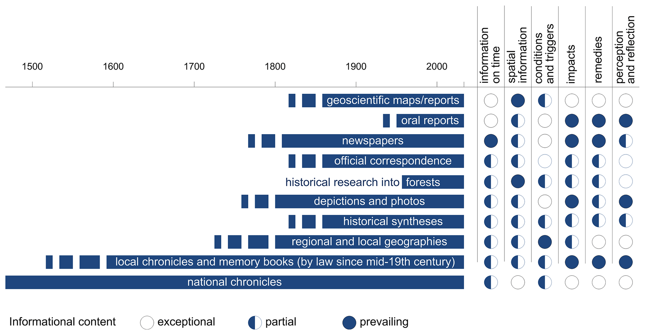
Figure 2An overview of available documentary data applicable for historical landslide research in Czechia with respect to their time coverage and informational content.
For the Outer Western Carpathians, Bíl et al. (2014) studied historical landsliding in an area around the village of Halenkovice (central part of OWC). They analysed documentary data and chronicles and interviewed eyewitnesses. They determined dates for 120 individual landslides. The oldest records were found in local chronicles and described landsliding in two villages (Jankovice and Košíky) in the close vicinity of Halenkovice in 1915. Bíl et al. (2020) created an overview of the chronology of landsliding in the Pavlovské vrchy, an area at the Czech–Austria border belonging to the Western Carpathian Flysch Belt. They determined dates for 30 historical landslides. The first written resource relates to a landslide record dating back to 1663.
In NW Czechia, Raška et al. (2015) established a regional historical landslide database which was compared with the central part of OWC in respect to the data availability and content. The multi-hazard database for the latter half of the nineteenth century (Raška and Dubišar, 2017) allowed for an exploration of the relative direct impacts of landslides on society. Finally, Raška (2019) used the landslide database to suggest five phases in the evolution of community-based landslide risk reduction and the various approaches and mechanisms employed in landslide mitigation measures.
Apart from these works, several studies have been published which used historical data to understand current local landslide hazards (Krejčí et al., 2017) and which explored the availability of documentary sources (Kozák and Rybář, 2003).
3.1 Data availability
Czechia has at its disposition an extremely diverse and extensive range of documentary data that may be explored to build historical landslide inventories. The number of these sources have been, however, subjected to academic scrutiny mostly in historical climatology and hydrology (Kjeldsen et al., 2014; Brázdil et al., 2018a). Similarly, Bíl et al. (2020) combined different documentary and archaeological data to compile a chronology of landsliding in the Pavlovské vrchy (Czechia, OWC) and described the basic historical landslide terminology. The conceptual differences in hydrometeorological and geomorphologic hazards do not allow for uncritical transposition of the climatological insights into the historical landslide research and therefore call for new insights into the potential of the documentary data (Crozier and Glade, 1999; Raška et al., 2014b).
The present landslide database is based on a systematic data search in documentary data (both written and iconographic) of several types with varying content, coverage, and availability. All the data used along with their characteristics are shown in Fig. 2. Most of these data are available in local archives in a printed or handwritten form (e.g. municipal and school chronicles, official correspondence, photos), while some were found in private collections. The primary documentary data were also complemented by a search in secondary (published) literature (e.g. newspapers, historical synthesis, historical research into forests) and in some areas also with oral inquiry. Within the data search, the lower time boundary for the database has not been set. The upper (recent) boundary, for the aim of the analysis in this work, was set at 1989. We have allowed, however, the database to remain open in order to allow users to add new landslides as well.
Table 1Structure of records in CHILDA.

∗ Mandatory attributes.
Note: the attributes which are bold are automatically added by the system and are not part of the user form for data entering.
3.2 Database structure
The database structure reflects the specific nature of documentary data, which usually do not allow to distinguish details of movement types, magnitudes, or velocities. For the individual attributes, we considered the existing classifications of movement types (Hungr et al., 2014), temporal dimensions of landsliding (Flageollet 1996), and landslide impacts (Alimohammadlou et al., 2013), and where possible, the attributes were designed to allow comparability with these classification schemes. Attributes related to each database record are presented in Table 1. Some of the attributes are added by users via a form. The items with an asterisk are mandatory and the items which are not part of the input form are underlined. They are processed automatically, within the system.
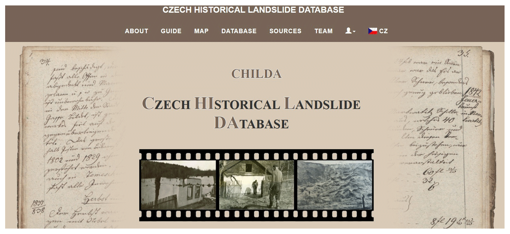
Figure 3Title page of CHILDA (https://childa.cz/?lang=en, last access: 19 August 2021).
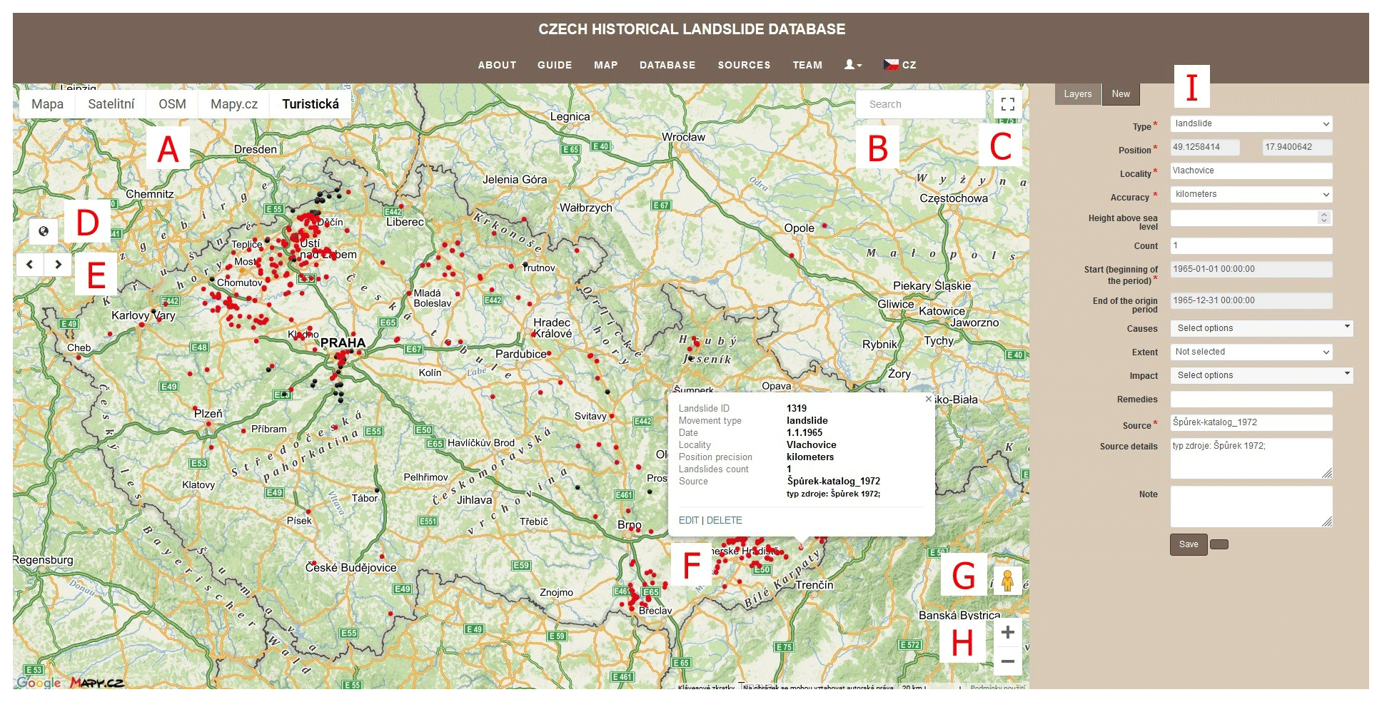
Figure 4Additional information on a landslide record can be obtained after clicking on a point in the map view. A new landslide can be added through the form (right side). A – background map; B – municipality; C – full-screen mode; D – full extent control; E – backward/forward screen; F – landslide description; G – Google Street View; H – zoom in/out; I – new landslide button. ©Mapy.cz.
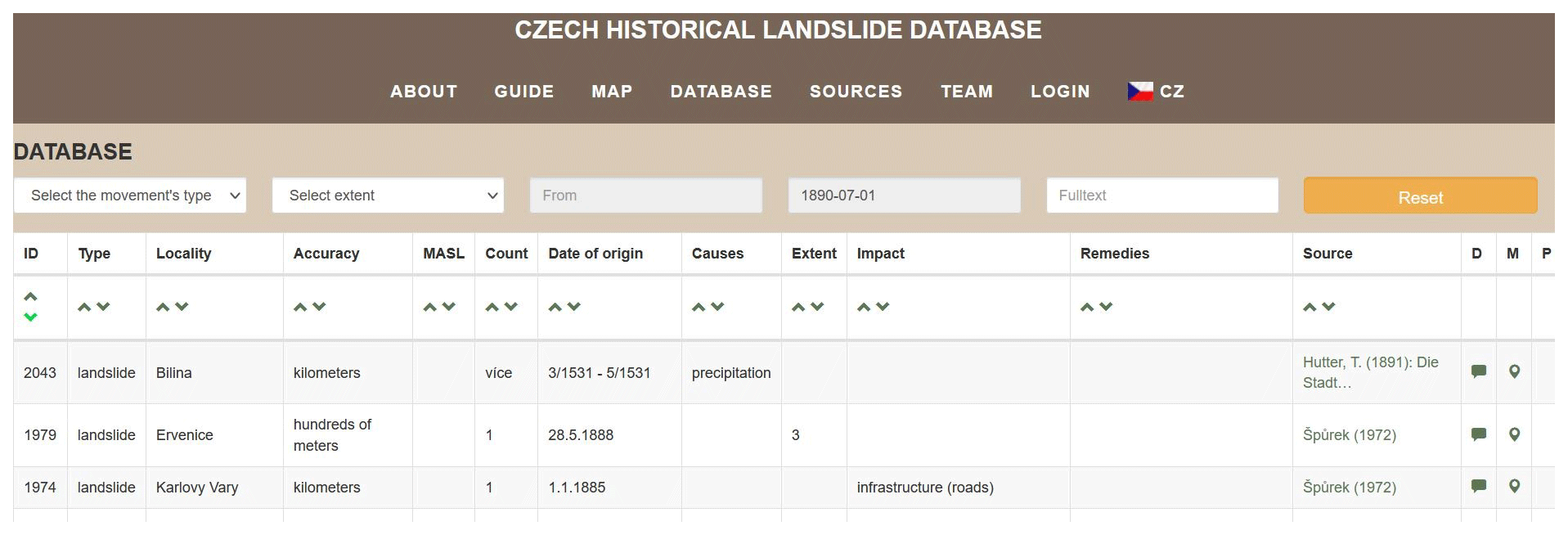
Figure 5A database table visualises information on landslides and allows for filtering data according to a number of parameters.
3.3 Web-map application
The database can be accessed through a web-map application at https://childa.cz/ (last access: 19 August 2021) (Fig. 3). CHILDA is administrated and hosted on the CDV – Transport Research Centre servers. The software requirement is as follows: PostgreSql/PostGIS, php, php NetteFramework, HTML, CSS, JQuery.
CHILDA users can select a background map (see Fig. 4, A). There are the following possibilities: base map, orthophoto, Open Street Map, Mapy.cz map, and a hiking map. A municipality or other geographical feature with a conventional name (mountains, etc.) can be selected via a form (B). The full-screen mode is launched when a user clicks on the icon (C). Standard map control features such as full extent (D), backward and forward screen (E), Google Street View (G), and zoom in/out (H) are also available here. A detailed landslide description is shown in the pop-up window after clicking on the landslide map symbol (F). A new landslide record can be added through a form (I). This panel contains two bookmarks. In the Layer, the symbology and the time filter can be seen. In New, a new landslide record can be added or an existing one can be edited. Only registered users can edit their own landslides. The edit button is visible in the pop-up window in the map or in the database after log in. There is currently no automatic validation of data entered by users to have the app as accessible and user friendly as possible. Three roles of users are defined: non-registered users, registered users (who are allowed to edit, delete their own data), and administrators (editing, deleting all data).
The landslide database is also accessible via a table (Fig. 5). Three filters are available: (i) movement type, (ii) extent, and (iii) time period. Full text searching is also possible. The given filter is kept when the map is selected unless it is reset by the user.
Table 2Database completeness on the basis of particular non-mandatory fields.
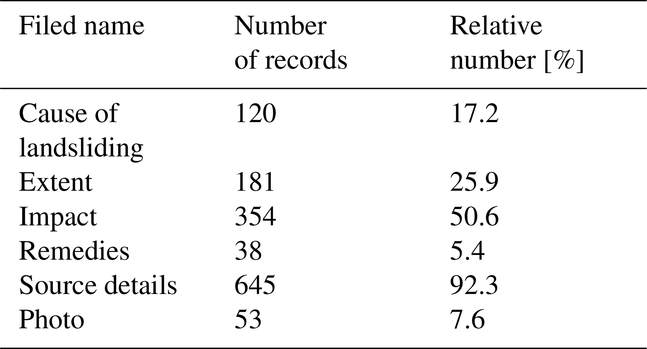
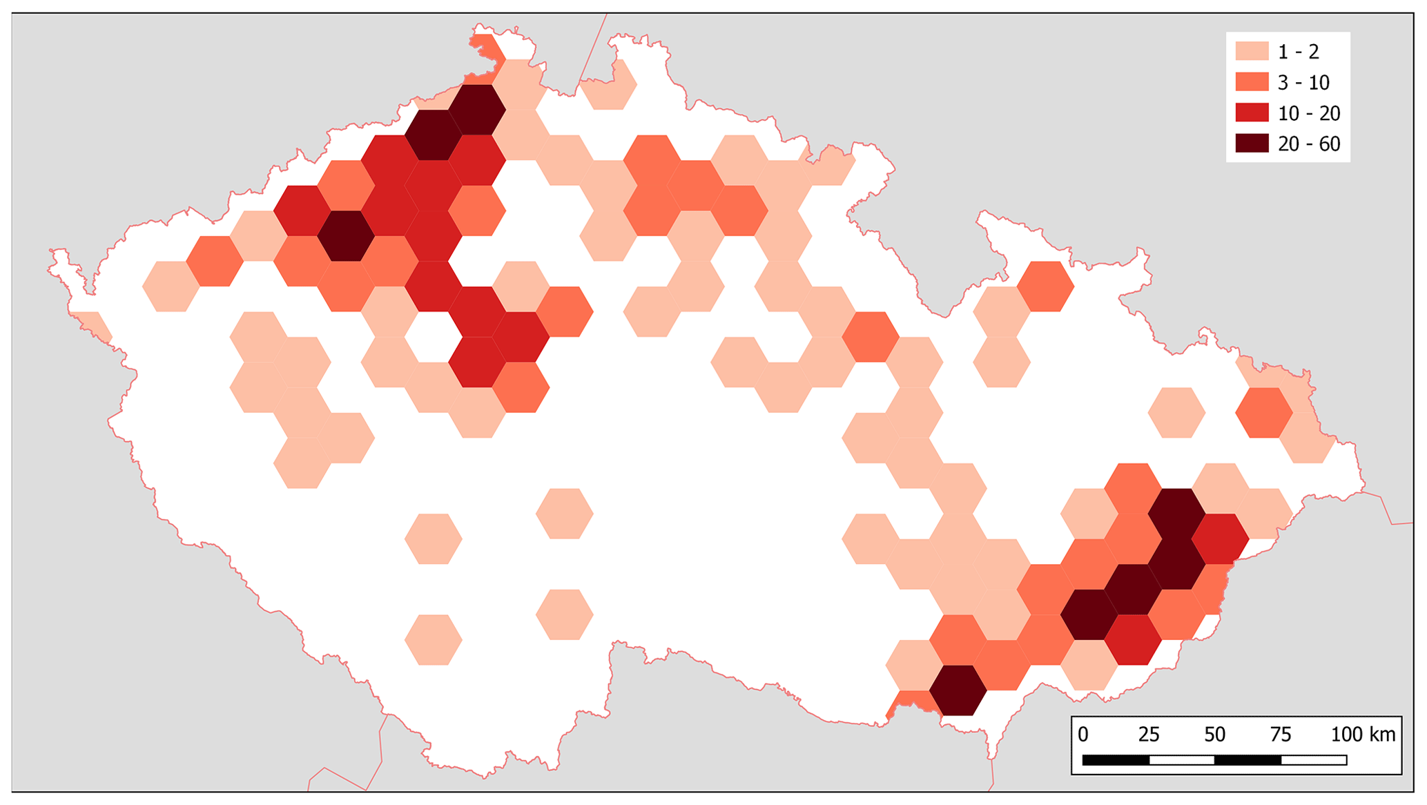
Figure 6Landslide density across Czechia.
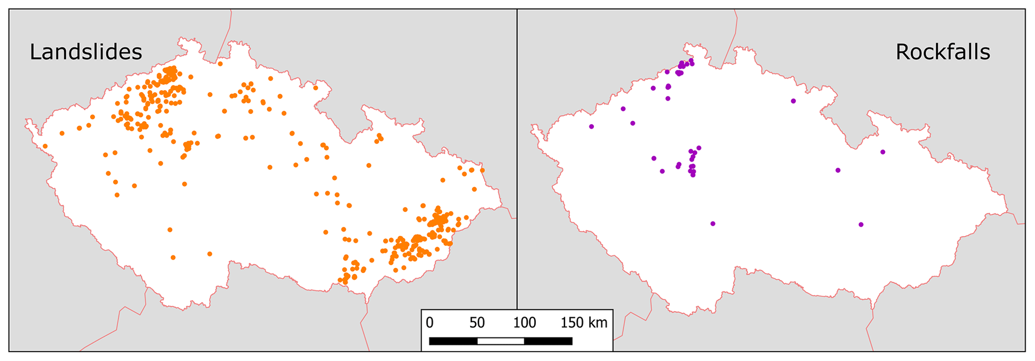
Figure 7Landslide and rockfall distribution.
Table 3The number of landslide records within centuries in Czechia between the twelfth and twentieth centuries.
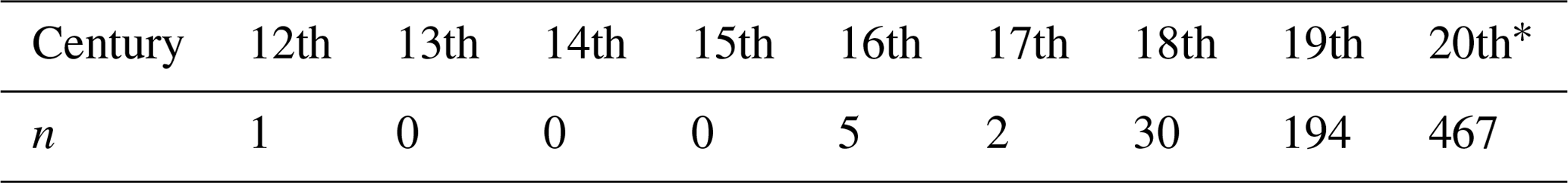
∗ up to and including 1989.
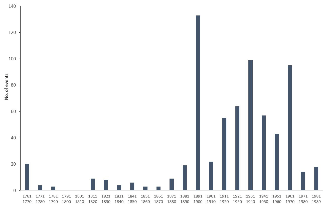
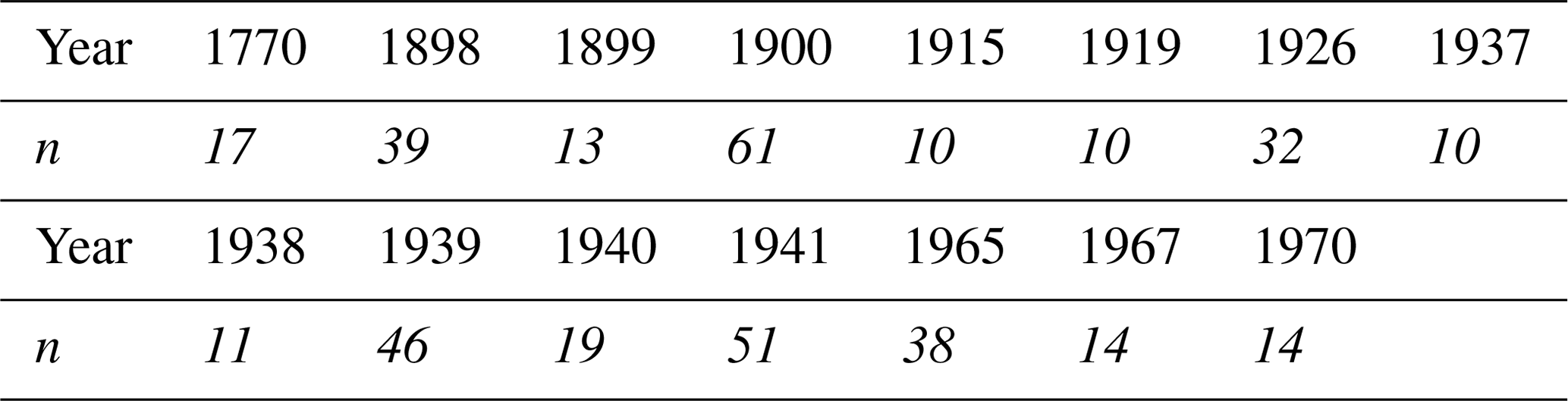
Table 4The most important 15 landslide years (1770–1989) when at least 10 records were found.
4.1 Landslide records in CHILDA
We present below an overview of data contained in CHILDA for the 1132–1989 period. The database contains 699 records, 619 of them categorised as landslides, 75 as rockfalls, and 5 as “other” kind of mass movements (earth flow, rockslide, or human-induced landslide). As regards temporal accuracy (see Table 1 for explanation), 231 records were determined exactly at single-day precision, 17 records are known with a weekly and 88 with a monthly precision. In total, 363 records were only attributed to a given year. Concerning the location accuracy, 111 records were localised precisely, 71 records with a precision of “tens of metres”, 260 records to “hundreds of metres”, and 478 to kilometres (mostly between 1–2 km, exceptionally up to 5 km in the mountain terrains of Czechia).
Table 2 presents database completeness that was determined based on several non-mandatory fields (cause of landsliding, extent, impact, etc.). The relative number [%] of particular fields always refers to all records in CHILDA (i.e. a proportion of 100 %). The average number of database completeness amounted to 33 %. An increase, however, in database completeness in the next years, based on the incorporation of new results arising from future research, is assumed.
Our data can also be compared to the previous landslide chronology compiled by Špůrek (1972) for the area of Czechia. Špůrek's last data on landsliding come from 1970. Our comparison consequently also ends this year. As for 1970, CHILDA currently (April 2021) contains 667 records. In total, 359 of these records were also part of Špůrek's overview. This indicates that our new investigation constitutes almost 50 % of new records in the database, i.e. records, which were not previously covered by Špůrek's catalogue. A major source of Špůrek's information about landsliding was newspapers. However, apart from newspapers, in our research, we also focused on the primary documentary data available in archives (e.g. chronicles, memory books, official correspondence). This approach has huge potential for revealing new and unique past landslide events during the ongoing research.
As Fig. 6 indicates, the highest density of historical landslide records in Czechia in the studied period concentrates on three primary landslide areas (OWC, CS, DV). Tens of landslide records come, however, from the area of the capital, Prague (VR) represented mainly by rockfalls. A higher occurrence of records is also typical for Bohemian Paradise sandstones (BP).
While landslide records come from all three core landslide areas, the rockfall records were typical for the west part of Czechia (DV area) and along the Vltava/Moldau river valley (VR) south of Prague (Fig. 7).
The temporal variability of the landslide records, represented by their numbers within centuries in the whole studied period, is shown in Table 3. The only one (and at the same time the oldest) record is known from the twelfth century (19 January 1132, see Sect. 4.2). No reports were detected between the thirteenth and fifteenth centuries, and only five and two reports were recorded in the sixteenth and seventeenth centuries, respectively. While only 8 records were found between the twelfth and seventeenth centuries and 30 records in the eighteenth century, the majority of the records are evidenced in the last 2 centuries. Landslide records covering the nineteenth century account for 27.8 %, whereas records from the twentieth century encompass 66.8 % of all reports.
Due to a rapid increase in landslide records after 1770, a decadal frequency of landslide records was created starting in 1761. The records in the period 1761–1989 represent 98 % of all records in CHILDA (Fig. 8). The highest numbers of records were registered during the decade of 1891–1900 (19 %) followed by the decades of 1931–1940 (14 %) and 1961–1970 (14 %). No records were detected, however, between 1791–1810. A significant rise in the number of records is apparent from the decade of 1891–1900 onwards and the course over the rest of the twentieth century is more or less variable. The variability has been in all probability influenced by important rainfall and/or snow thaw events.
The earliest important landslide year occurred in 1770. A minimal number of landslide records to determine a particular year as the most important landslide year was set at 10 reports. From 1770, 15 such years were revealed encompassing 55 % of all records on mass movements (385 out of 699) (Table 4). The highest number of landslide records was found in 1900 (61), 1941 (51), and 1939 (46), representing 15.8 %, 13.2, and 11.9 % of the most important 15 landslide years, respectively.
4.2 The oldest records on landsliding
The issue of the precise determination of dates of landslide activity becomes more important when we look back in history. The oldest records describing landslides in Czechia suffer from spatiotemporal inhomogeneity. CHILDA currently contains 14 reports of mass movements which took place before 1770, the first most important landslide year (see Table 4). It is important to mention that in 50 % of all recorded cases, citations referring to historical landslides in this study came from the Špůrek landslide catalogue (1972). Because of our efforts at maximum authenticity, we took over these citations although we were not able to study some referenced citations personally in certain cases.
The oldest known written report describes a rockfall in Prague–Chuchle (VR area) on 19 January 1132 (Strnad, 1790). More detailed information about three landslide events in spring 1531 is described by chroniclers from Litoměřice and Bílina (CS area). Landsliding was reported from the beginning of April until the middle of May and affected Radobýl Hill near Litomeřice and Holý vrch near Zahořany village. Vineyards planted on the hills and slopes slid and two great parts of Radobýl Hill slipped down, including trees and plants. Similarly, a large portion of Holý vrch slid at that time and a series of other landslides were observed (Smetana, 1978). In the wet spring of 1531, several landslides also occurred in the surroundings of the nearby Bílina River after a flood (Hutter, 1891).
A day before Christmas Eve of 1595 a landslide occurred near Vraclav–Domoradice village (Špůrek, 1967). According to Kárník et al. (1957), seismic activity preceded this event. In March 1599, extraordinary damage was described in Litoměřice (CS area) as a consequence of a great deal of snow and wet weather (Brázdil et al., 2013.b). The chronicler described the situation as follows: “A piece of town wall near St. Laurentius [church] fell and collapsed ... On 16 March ... at the cemetery ... a huge section slipped down too so the graves opened and the dead bodies were thrown out .... That same year, in the month of March, extensive damage to vineyards was experienced by many [people], the walls caved in and one vineyard after another slid and all of this was happening due to great wetness”. In addition, a number of springs appeared on the surface, the cellars were full of water which had to be pumped out, and one house even slipped away (Smetana, 1978).
The oldest landslide report from OWC, based on a written record, occurred in the Pavlovské vrchy in Pavlov village in 1663 (Maca, 1994; Kryčer). In contrast to previous mass movement events, continuing landsliding was also recorded on the same street in 1667 (Štefková-Vajayová, 2001), 1715, 1730, and 1763 (Maca, 1994; Kryčer). A detailed description of landslide damage before 1763 is missing, but the particular landslide consequences in the area of the Pavlovské vrchy in the following years were described by Bíl et al. (2020).
A brief report of landslide occurrence comes from Dečín–Chrochvice (DV area) in 1736 (Mauder, 1931). This event was the first one from a series of consequent landslides in 1823, 1850, and 1914 which affected an area of 16 ha and damaged buildings and local infrastructure (Špůrek, 1972). A similar lack of information relates to a landslide in Ústí nad Labem (DV area) in 1767 (Špůrek, 1972). In contrast the collapse of a parish cellar in Líbeznice village in 1769 is relatively well described by Třebízský (1885), who mentioned great wetness and surfeit of water this year.
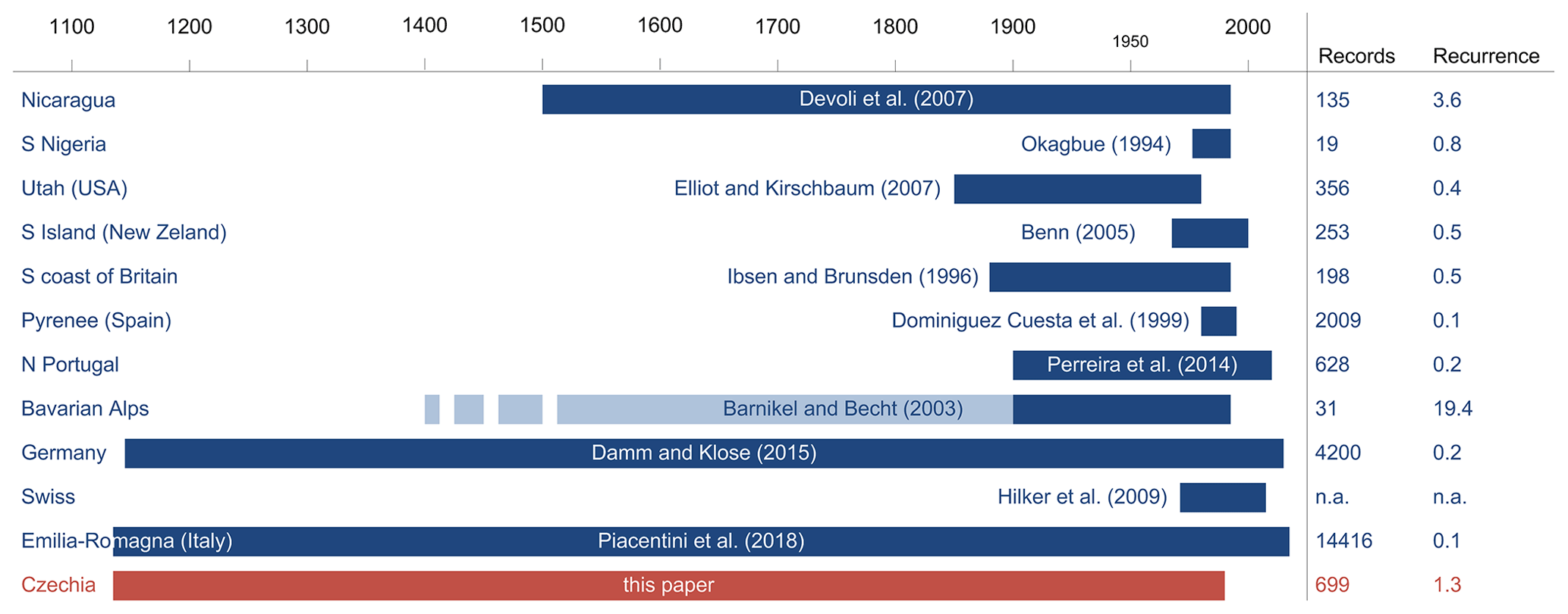
Figure 9Comparison of CHILDA and other existing historical landslide
databases in terms of the number of records and recurrence.
Note: dark-blue stripes mark the periods under study. In the case of compound (multi-hazard) databases, light-blue marks complete the studied period for which geohazards other than landslides have been found, whereas dark-blue stands for landsliding. Dashed stripes represent an unspecified beginning (e.g. since the fifteenth century without explicit dating of the oldest record).
5.1 CHILDA and other historical landslide databases
We presented an overview of the CHILDA database where as many as possible records on historical landsliding, which took part in the area of modern Czechia, were collected. This database currently contains 699 records (between 1132 and 1989) and can be compared to other similar databases which have been completed in other countries (Fig. 9).
It should be noted, however, that similarly to other databases CHILDA displays high asymmetry in the number of recorded events over time. First, the sole oldest record dated to 1132 extends the span by 4 centuries as further records are only dated to 1531. Second, the majority of records (93 %) relates landsliding that occurred since 1850. In contrast, and unlike the other databases, CHILDA also records only a few increased landslide frequencies in the pre-industrial periods, namely the 1770 landslide year (17 landslides) resulting from the central European adverse climate (Raška et al., 2016) and 1817 (with five landslides) possibly influenced by the Tambora eruption in 1815 (Brázdil et al., 2016b).
5.2 Limitations of the CHILDA database
As with similar databases which focus on historical records and therefore depend on availability, accessibility, and reliability of original sources, CHILDA also has certain limitations that may be grouped in the following kinds of uncertainties.
(a) Uncertainty is usually related to a description of events as landslides (mass movements in general) in the documentary records which were named differently. The terminological inconsistency, closely connected with exploiting the wide range of documentary data, lasted at least until the twentieth century and persists in media reports up until recent days. This inconsistency was caused by gaps in scientific knowledge in the first Czech modern landslide classification published in 1954 (Záruba and Mencl, 1954; compared with much earlier attempts in English listed in Cruden, 2003) and by cultural and resulting language diversity in the Czech Lands up until 1945 (i.e. Czech and German culture realms). Raška et al. (2015) analysed historical landslides in two Czech regions and found seven different terms referring to landslides and three for rockfalls. In total, five German different terms were used to describe the landslides in the Pavlovské vrchy (OWC) between the middle of the seventeenth to the twentieth centuries (Bíl et al., 2020).
(b) Moreover, documentary evidence was not continuous, sometimes only depending on concrete persons. Chroniclers were often not interested in this phenomenon as there were more dangerous ones in this area, such as floods (Brázdil et al., 2011; Elleder et al., 2020), strong winds (Brázdil et al., 2004, 2017, 2018b), and episodes of drought (Brázdil et al., 2013a; Dolák et al., 2015; Řezníčková et al., 2015; Brázdil et al., 2016a, 2019). There is obviously also a significant growth of available sources especially since the nineteenth century, which may distort the represented landslide frequencies over time. The availability of sources also displays a distinct geographical variation due to different historical developments in individual regions. Several smaller uncertainties related to historical landslides have thus appeared, e.g. a lack of narrative sources before 1920 and in the Czech border areas after 1945 (Bíl et al., 2020) or difficulties with recognition of landslides and scoured slopes during the floods in early documentary records. As regards the Czech border areas, chronicles were lost or carried away mainly by German inhabitants displaced after 1945. This occurred, along with other regions, in the landslide-prone areas of the Pavlovské vrchy or parts of NW Czechia (CS and DV). Only some of the lost information from the chronicles became available again via a historical synthesis published in the second half of the twentieth century (Bíl et al., 2020). In addition, keeping memory books was recommended by the state in 1836 and chronicles were made mandatory from 1920 onward; therefore any older events are either missing in these sources or were recorded retrospectively with some risk of misinterpretation.
(c) Additional problems include uncertainties resulting from difficult to identify duplicities in records of different coverage (i.e. the issue of upscaling and downscaling) and from false frequency peaks caused by a combination of continual (regularly published) and stationary (published once as a collection of records) data (Raška et al., 2014b). Both these issues may result in false peaks and gaps in the landslide time series. Also, it cannot be ruled out that certain records on landsliding in the past, albeit once existing, were subsequently lost. Verification of data through checking of the data reliability based on comparison among more sources or field research is not always possible and reliable, and therefore any database must always be considered a catalogue of records rather than events themselves. In the case of the catalogue of event utilisation, these uncertainties relate to, e.g., the example of 12 records in CHILDA that describe more than one event, but the real number is not known. Such events could therefore present events with higher intensities than other events where only single landslides were reported.
In addition, any quantification of landslide extents and their impact is also complicated. We therefore decided to only select from a few attributes generally describing impacts. Reactivations of landslide at the same place could also not be determined exactly. Sometimes, as documented in Bíl et al. (2014) from the village of Halenkovice, villagers from landslide-prone areas were used to seeing the landslides often and as a result did not pay attention to them. In contrast, rare landsliding in other areas attracted the attention of the locals. Construction work, related to the first railways across OWC, also both found and caused some landslides (e.g. Záruba, 1938). The apparent lack of documented landslides before 1920 in the Carpathians (except for the Pavlovské vrchy) was attributed by Bíl et al. (2014) to dispersed settlements built primarily from wood, the majority of unpaved roads, and relatively sparse inhabitation in the area. Limited spatial accuracies of historical records often influence any reliable evaluation regarding the possible structural or anthropogenic triggers.
Despite all these uncertainties, documentary evidence stands as a valuable and indispensable source of data describing the occurrence and the consequences of landslides in Czechia during the last 5 centuries.
5.3 Further applications and development of the database
Data currently contained in CHILDA can be further analysed in order to delineate and explain their temporal and spatial concentration. While the spatial extent of landsliding can easily be understood as an apparent relation to lithology, temporal distribution has been influenced by important rainfall and/or snow thaw events. Information on landslides with known dates of activities, which is the case for CHILDA records, can therefore be used in such a determination of regional rainfall or total water content triggers. Bíl et al. (2016) have, for example, already utilised the information on landslide periods, defined for an area in the central part of OWC, to determine rainfall thresholds for this area. Further applications of the data will include analyses of the long-term changes in landslide risk reduction approaches, their effectiveness, and efficiency (Caloireo et al., 2014; Klose et al., 2016) framed by disaster risk reduction strategies (DRR) (Bíl et al., 2014; UNDRR, 2015). Analysis of community responses to landslide risk in individual landslide-prone areas has already been published by Raška (2019) and Klimeš et al. (2020) and allowed for an exploration of both formal (planning, DRR administration) and informal (community help, mobilisation of local knowledge) mechanisms in landslide risk reduction.
We presented the online landslide database CHILDA (Czech Historical Landslide Database), which summarises information about landslides which took place in the area of Czechia (the Czech Republic). The database is freely accessible via the http://childa.cz/ (last access: 19 August 2021) website and currently includes 699 records (spanning the 1132–1989 period). The oldest record relates to a rockfall which took place in 1132. In total, the database doubled the number of records known from the previous historical database in Czechia. We further described in detail another eight of the oldest records (1531 to 1730) and analysed centennial and decadal frequencies of landslide records. It was demonstrated that 55 % of all recorded landslide events occurred only within 15 years of the extreme landslide incidence. Finally, the limitations of the documentary data sources have been summarised pointing at uncertainties within the database. The future research direction should focus on analysing historical landslide triggers and their thresholds, on changes in spatiotemporal patterns of landslide impacts on society, and on narratives of societal adaptive management to landslide risk.
Data are available for free via the CHILDA website (https://childa.cz; CHILDA, 2021) in the form of a table and map. The website also includes guidelines for data use and referencing.
MB, PR and LD collaborated on the conceptualisation of the study and empirical research; JK programmed the CHILDA and processed landslide data. All authors assisted with writing the draft and the final version of the manuscript.
The authors declare that they have no conflict of interest.
Publisher's note: Copernicus Publications remains neutral with regard to jurisdictional claims in published maps and institutional affiliations.
Thanks go to Vojtěch Cícha for help with the preparation of figures, Vilém Zábranský and Jiří Riezner for suggesting new data sources that included records on landsliding, and David Livingstone for assistance with language editing.
Michal Bíl and Jan Kubeček worked with the financial support of the Ministry of Transport of the Czech Republic within the programme of long-term conceptual development of research institutions. Pavel Raska was supported by the project Smart City – Smart Region – Smart Community (CZ.02.1.01/0.0/0.0/17_048/0007435) within the Operational Program Research, Development and Education of the Czech Republic. Lukáš Dolák was supported by SustES – Adaptation strategies for sustainable ecosystem services and food security under adverse environmental conditions (CZ.02.1.01/0.0/0.0/16_019/0000797).
This paper was edited by Paola Reichenbach and reviewed by two anonymous referees.
Alimohammadlou, Y., Najafi, A., and Yalcin, A. Landslide process and impacts: A proposed classification method. CATENA, 104, 219–232, https://doi.org/10.1016/j.catena.2012.11.013, 2013.
Bíl, M. and Müller, I.: The origin of shallow landslides in Moravia (Czech Republic) in the spring of 2006, Geomorphology, 99, 246–253, https://doi.org/10.1016/j.geomorph.2007.11.004, 2008.
Bíl, M., Krejčí, O., Bílová, M., Kubeček, J., Sedoník, J., and Krejčí, V.: A Chronology of landsliding and its impactss on the village of Halenkovice, Outer Western Carpathians, Geografie, 119, 342–363, https://doi.org/10.37040/geografie2014119040342, 2014.
Bíl, M., Andrášik, R., Zahradníček, P., Kubeček, J., Sedoník, J., and Štěpánek, P.: Total water content thresholds for shallow landslides, Outer Western Carpathians, Landslides, 13, 337–347, https://doi.org/10.1007/s10346-015-0570-9, 2016.
Bíl, M., Andrášik, R., Kubeček, J., Křivánková, Z., and Vodák, R.: RUPOK: An Online Landslide Risk Tool for Road Networks, Advancing Culture of Living with Landslides, Vol 5: Landslides in Different Environments, edited by: Mikoš, M., Vilímek, V., Yin, Y., and Sassa, K., Springer International Publishing Ag, Cham, 19–26 pp., 2017.
Bíl, M., Krejčí, O., Dolák, L., Krejčí, V., Martínek, J., and Svoboda, J.: A chronology of landsliding based on archaeological and documentary data: Pavlovské vrchy Hills, Western Carpathian Flysch Belt, Sci. Rep.-UK, 10, 976, https://doi.org/10.1038/s41598-020-57551-4, 2020.
Brázdil, R., Dobrovolný, P., Štekl, J., Kotyza, O., Valášek, H., and Jež, J.: History of weather and climate in the Czech Lands. VI, Strong winds, 1st published edn., History of Weather and Climate in the Czech Lands, Masaryk University, Brno, 377 pp., 2004.
Brázdil, R., Řezníčková, L., Valášek, H., Havlíček, M., Dobrovolný, P., Soukalová, E., Řehánek, T., and Skokanová, H.: Fluctuations of floods of the River Morava (Czech Republic) in the 1691–2009 period: interactions of natural and anthropogenic factors, Hydrolog. Sci. J., 56, 468–485, https://doi.org/10.1080/02626667.2011.564175, 2011.
Brázdil, R., Dobrovolný, P., Trnka, M., Kotyza, O., Řezníčková, L., Valášek, H., Zahrádníček, P., and Štěpánek, P.: Droughts in the Czech Lands, 1090–2012 AD, Clim. Past, 9, 1985–2002, https://doi.org/10.5194/cp-9-1985-2013, 2013a.
Brázdil, R., Kotyza, O., Dobrovolný, P., Řezníčková, L., and Valášek, H.: Climate of the Sixteenth Century in the Czech Lands, History of Weather and Climate in the Czech Lands, Masaryk University, Brno, 286 pp., 2013b.
Brázdil, R., Raška, P., Trnka, M., Zahradníček, P., Valášek, H., Dobrovolný, P., Řezníčková, L., Treml, P., and Stachoň, Z.: The Central European drought of 1947: causes and consequences, with particular reference to the Czech Lands, Clim. Res., 70, 161–178, https://doi.org/10.3354/cr01387, 2016a.
Brázdil, R., Řezníčková, L., Valášek, H., Dolák, L., and Kotyza, O.: Climatic effects and impacts of the 1815 eruption of Mount Tambora in the Czech Lands, Clim. Past, 12, 1361–1374, https://doi.org/10.5194/cp-12-1361-2016, 2016b.
Brázdil, R., Szabó, P., Dobrovolný, P., Řezníčková, L., Kotyza, O., Suchánková, S., and Valášek, H.: Windstorm of the eighteenth century in the Czech Lands: course, extent, impacts, Theor. Appl. Climatol., 129, 623–632, https://doi.org/10.1007/s00704-016-1806-x, 2017.
Brázdil, R., Kiss, A., Luterbacher, J., Nash, D. J., and Řezníčková, L.: Documentary data and the study of past droughts: a global state of the art, Clim. Past, 14, 1915–1960, https://doi.org/10.5194/cp-14-1915-2018, 2018a.
Brázdil, R., Stucki, P., Szabó, P., Řezníčková, L., Dolák, L., Dobrovolný, P., Tolasz, R., Kotyza, O., Chromá, K., and Suchánková, S.: Windstorms and forest disturbances in the Czech Lands: 1801–2015, Agr. Forest Meteorol., 250, 47–63, https://doi.org/10.1016/j.agrformet.2017.11.036, 2018b.
Brázdil, R., Dobrovolný, P., Trnka, M., Řezníčková, L., Dolák, L., and Kotyza, O.: Extreme droughts and human responses to them: the Czech Lands in the pre-instrumental period, Clim. Past, 15, 124, https://doi.org/10.5194/cp-15-1-2019, 2019.
Burda, J., Hartvich, F., Valenta, J., Smítka, V., and Rybář, J.: Climate-induced landslide reactivation at the edge of the Most Basin (Czech Republic) – progress towards better landslide prediction, Nat. Hazards Earth Syst. Sci., 13, 361–374, https://doi.org/10.5194/nhess-13-361-2013, 2013.
Cajz, V.: The České středohoří Mts.: volcanostratigraphy and geochemistry, Geolines, 9, 21–28, 1999.
Caloiero, T., Pasqua, A. A., and Petrucci, O.: Damaging Hydrogeological Events: A Procedure for the Assessment of Severity Levels and an Application to Calabria (Southern Italy), Water, 6, 3652–3670, https://doi.org/10.3390/w6123652 2014.
Caracciolo, D., Arnone, E., Conti, F. L., and Noto, L. V.: Exploiting historical rainfall and landslide data in a spatial database for the derivation of critical rainfall thresholds, Environ. Earth Sci.,76, 222, https://doi.org/10.1007/s12665-017-6545-5 2017.
Crozier, M. J. and Glade, T.: Frequency and magnitude of landsliding: Fundamental research issues, Z. Geomorphol. Supp., 115, 141–155, https://doi.org/10.1127/zfgsuppl/115/1999/141, 1999.
Cruden, D. M.: The First Classification of Landslides?, Environmental and Engineering Geoscience, 9, 197–200, https://doi.org/10.2113/9.3.197, 2003.
Čermák, J.: Sesutí stráně a hrazené jezero u Mladotic: předběžná zpráva [Landslide and the landslide-dammed lake of Mladotice: a preliminary report], Sborník České společnosti zeměvědné, 18, 19–23, 1912.
CHILDA – Czech Historical Landslide Database: available at: https://childa.cz, last access: 9 April 2021.
CHMI – Czech Hydrometeorological Institute: available at: http://www.chmi.cz, last access: 9 April 2021.
Czech Geological Survey: available at: http://www.geology.cz (last access: 8 February 2021), 2012a.
Czech Geological Survey Map Server: available at: https://mapy.geology.cz/arcgis/rest/services/Inspire/GM2_5mil/MapServer?f=jsapi (last access: 5 March 2021), 2012b.
Damm, B. and Klose, M.: The landslide database for Germany: Closing the gap at national level, Geomorphology, 249, 82–93, https://doi.org/10.1016/j.geomorph.2015.03.021, 2015.
Dědina, V.: Sesouvání stráně na Chlomku u Ml. Boleslavě [Landsliding at Chloumek by Ml. Boleslav town], Sborník České společnosti zeměvědné, 2, 40–41, 1896.
Dědina, V.: Sesutí půdy pod Chlomkem u Ml. Boleslavi [Landslide of earth at Chloumek by Ml. Boleslav town], Sborník České společnosti zeměvědné, 22, 160–166, 1916.
Devoli, G., Morales, A., and Høeg, K.: Historical landslides in Nicaragua – collection and analysis of data, Landslides, 4, 5–18, https://doi.org/10.1007/s10346-006-0048-x, 2007.
Dolák, L., Brázdil, R., Řezníčková, L., and Valášek, H.: Selected drought impacts in South Moravia in the 18th and 20th centuries based on documentary evidence, In: Otmar Urban, Mirka Šprtová, Karel Klem. Global Change: A Complex Challenge. Conference Proceedings. Global Change Research Centre, The Czech Academy of Sciences, v.v.i., Brno, 30–33 pp., 23–24 March 2015, 2015.
Elleder, L., Krejčí, J., Racko, S., Daňhelka, J., Šírová, J., and Kašpárek, L.: Reliability check of flash-flood in Central Bohemia on 25 May 1872, Global Planet. Change, 187, 103094, https://doi.org/10.1016/j.gloplacha.2019.103094, 2020.
Elliott, A. and Kirschbaum, M.: The preliminary landslide history database of Utah, 1850–1978, Utah Geological Survey, 514, 5, 2007.
Forczek, I.: Destruction of marginal parts of sandstone plateaus in the protected landscape area Bohemian Paradise, Acta Geodyn. Geomater., 5, 267–274, 2008.
Froude, M. J. and Petley, D. N.: Global fatal landslide occurrence from 2004 to 2016, Nat. Hazards Earth Syst. Sci., 18, 2161–2181, https://doi.org/10.5194/nhess-18-2161-2018, 2018.
Flageollet, J.-C.: The time dimension in the study of mass movements. Geomorphology, 15, 185–190, https://doi.org/10.1016/0169-555X(95)00069-H, 1996.
Gariano, S. L. and Guzzetti, F.: Landslides in a changing climate, Earth-Sci. Rev., 162, 227–252, https://doi.org/10.1016/j.earscirev.2016.08.011, 2016.
Glade, T., Albini, P., and Frances, F.: An introduction to the use of historical data in natural hazard assessments, Use of Historical Data in Natural Hazard Assessments, edited by: Glade, T., Albini, P., and Frances, F., Springer, Dordrecht, 2001.
Guzzetti, F., Cardinali, M., and Reichenbach, P.: The AVI project: A bibliographical and archive inventory of landslides and floods in Italy, Environ. Manage., 18, 623–633, https://doi.org/10.1007/BF02400865, 1994.
Hermanns, R., Hansen, L., Sletten, K., Böhme, M., Bunkholt, H., Dehls, J., Eilertsen, R., Fischer, L., L'Heureux, J.-S., Høgaas, F., Nordahl, B., Oppikofer, T., Rubensdotter, L., Solberg, I.-L., Stalsberg, K., and Yugsi Molina, F. X.: Systematic geological mapping for landslide understanding in the Norwegian context, in: Landslide and engineered slopes: protecting society through improved understanding, edited by: Eberhardt, E., Froese, C., Turner, A. K., and Leroueil, S., Taylor and Francis Group, London, 265–271, 2013.
Herrera, G., Mateos, R. M., García-Davalillo, J. C., Grandjean, G., Poyiadji, E., Maftei, R., Filipciuc, T.-C., Jemec Auflič, M., Jež, J., Podolszki, L., Trigila, A., Iadanza, C., Raetzo, H., Kociu, A., Przyłucka, M., Kułak, M., Sheehy, M., Pellicer, X. M., McKeown, C., Ryan, G., Kopačková, V., Frei, M., Kuhn, D., Hermanns, R. L., Koulermou, N., Smith, C. A., Engdahl, M., Buxó, P., Gonzalez, M., Dashwood, C., Reeves, H., Cigna, F., Liščák, P., Pauditš, P., Mikulėnas, V., Demir, V., Raha, M., Quental, L., Sandić, C., Fusi, B., and Jensen, O. A.: Landslide databases in the Geological Surveys of Europe, Landslides, 15, 359–379, https://doi.org/10.1007/s10346-017-0902-z, 2018.
Hroch, Z., Kycl, P., and Šebesta, J.: Landslide hazards in North Bohemia, in: Landslides: Proceedings of the First European Conference on Landslides, edited by: Rybář, J., Stemberk, J., and Wagner, P., Swets and Zeitlinger, Lisse, 207–212, 24–26 June 2002, 2002.
Hungr, O., Leroueil, S., and Picarelli, L.: The Varnes classification of landslide types, an update, Landslides, 11, 167–194, https://doi.org/10.1007/s10346-013-0436-y, 2014.
Hutter, T.: Die Stadt Bilin und ihre Geschichte von der ältesten Zeit bis auf unsere Tage (1890), Verlag des Bürgermeisteramtes, Bilin, 168 pp., 1891.
Jüttner, K.: Die Rutschgebiete an den Hängen der Pollauer Berge, Firgenwald, 4, 108–121, 1931.
Jüttner, K.: Die erdgeschichtliche Entwicklung des Bodens der Gemeinde Pollau, Deutsch-mähr.-schles. Heimat, 11/12, 23, 1–6, 1937.
Kalvoda, J. and Balatka, B.: Chronodynamics of the Labe River antecedence in the Děčínská vrchovina Highland, Czech Republic, Acta Montana IRSM AS CR Series A, 8, 43–60, 1995.
Kárník, V., Michal, E., and Molnár, A.: Erdbebenkatalog der Tschechoslowakei bis zum Jahre 1956, Travaux Géophysiques, 69, 411–598, 1957.
Kjeldsen, T. R., Macdonald, N., Lang, M., Mediero, L., Albuquerque, T., Bogdanowicz, E., Brázdil, R., Castellarin, A., David, V., Fleig, A., Gul, G. O., Kriauciuniene, J., Kohnová, S., Merz, B., Nicholson, O., Roald, L. A., Salinas, J. L., Sarauskiene, D., Šraj, M., Strupczewski, W., Szolgay, J., Toumazis, A., Vanneuville, W., Veijalainen, N., and Wilson, D.: Documentary evidence of past floods in Europe and their utility in flood frequency estimation, J. Hydrol., 517, 963–973, https://doi.org/10.1016/j.jhydrol.2014.06.038, 2014.
Klimeš, J., Stemberk, J., Blahut, J., Krejčí, V., Krejčí, O., Hartvich, F., and Kycl, P.: Challenges for landslide hazard and risk management in “low-risk” regions, Czech Republic-landslide occurrences and related costs (IPL project no. 197), Landslides, 14, 771–780, https://doi.org/10.1007/s10346-017-0798-7, 2017.
Klimeš, J., Müllerová, H., Woitsch, J., Bíl, M., and Křížová, B.: Century-long history of rural community landslide risk reduction, Int. J. Disast. Risk. Re., 51, 101756, https://doi.org/10.1016/j.ijdrr.2020.101756, 2020.
Klose, M., Maurischat, P., and Damm, B.: Landslide impacts in Germany: A historical and socioeconomic perspective, Landslides, 13, 183–199, https://doi.org/10.1007/s10346-015-0643-9 2016.
Kozák, J. and Rybář, J.: Special Contribution: Pictorial Series of the Manifestations of the Dynamics of the Earth: 3. Historical Images of Landslides and Rock Falls, Stud. Geophys. Geod., 47, 221–232, https://doi.org/10.1023/A:1022220126463, 2003.
Krejčí, J.: Sesuvná území na Zlínsku [Landslide areas in the Zlín region], Práce Moravské přírodovědecké společnosti, 15, F156, 1943.
Krejčí, O., Krejčí, V., Kycl, P., Paleček, M., and Rybář, J.: Bohyně in Děčín district – the largest landslide area in the Czech Republic, Geoscience Research Reports, 50, 227–234, https://doi.org/10.3140/zpravy.geol.2017.38 2017.
Krejčí, O., Baroň, I., Bíl, M., Hubatka, F., Jurová, Z., and Kirchner, K.: Slope movements in the Flysch Carpathians of Eastern Czech Republic triggered by extreme rainfalls in 1997: a case study, Phys. Chem. Earth, Pt. A/B/C, 27, 1567–1576, https://doi.org/10.1016/S1474-7065(02)00178-X, 2002.
Kryčer, R.: Dějiny obcí Bavory, Bulhary, Klentnice, Mušov, Pavlov, Perná, Sedlec, Dolní Věstonice, Horní Věstonice [Histories of the municipalities of Bavory, Bulhary, Klentnice, Mušov, Pavlov, Perná, Sedlec, Dolní Věstonice and Horní Věstonice], The State District Archive in Břeclav, (undated document).
Maca, J.: Pollauer Heimatbuch: 1334–1946: Geschichte und Schicksal einer deutschen Gemeinde in Südmähren, Selbstverlag, Wien, 551 pp., 1994.
Marc, O., Stumpf, A., Malet, J.-P., Gosset, M., Uchida, T., and Chiang, S.-H.: Initial insights from a global database of rainfall-induced landslide inventories: the weak influence of slope and strong influence of total storm rainfall, Earth Surf. Dynam., 6, 903–922, https://doi.org/10.5194/esurf-6-903-2018, 2018.
Mauder, E.: Chronik von Bodenbach, Verlag der Stadtgemeinde, Tetschen-Bodenbach, 445 pp., 1931.
Pánek, T., Brázdil, R., Klimeš, J., Smolková, V., Hradecký, J., and Zahradníček, P.: Rainfall-induced landslide event of May 2010 in the eastern part of the Czech Republic, Landslides, 8, 507–516, https://doi.org/10.1007/s10346-011-0268-6, 2011.
Pereira, S., Zêzere, J. L., Quaresma, I. D., and Bateira, C.: Landslide incidence in the North of Portugal: Analysis of a historical landslide database based on press releases and technical reports, Geomorphology, 214, 514–525, https://doi.org/10.1016/j.geomorph.2014.02.032, 2014.
Piacentini, D., Troiani, F., Daniele, G., and Pizziolo, M.: Historical geospatial database for landslide analysis: the Catalogue of Landslide OCcurrences in the Emilia-Romagna Region (CLOCkER), Landslides, 15, 811–822, https://doi.org/10.1007/s10346-018-0962-8, 2018.
Pilous, V.: Strukturní mury v Krkonoších – 1. část, Opera Corcontica, 10, 15–69, 1973.
Raška, P., Hartvich, F., Cajz, V., and Adamovič, J.: Structural setting of the Certovka landslide (Usti nad Labem, Czech Republic): morphostructural analysis and electrical resistivity tomography, Geol. Q., 58, 85–98, https://doi.org/10.7306/gq.1134, 2014a.
Raška, P., Zábranský, V., Dubišar, J., Kadlec, A., Hrbáčová, A., and Strnad, T.: Documentary proxies and interdisciplinary research on historic geomorphologic hazards: a discussion of the current state from a central European perspective, Nat. Hazards, 70, 705–732, https://doi.org/10.1007/s11069-013-0839-z, 2014b.
Raška, P., Klimeš, J., and Dubišar, J.: Using Local Archive Sources to Reconstruct Historical Landslide Occurrence in Selected Urban REgions of the Czech Republic: Examples from Regions with Different Historical Development, Land Degrad. Dev., 26, 142–157, https://doi.org/10.1002/ldr.2192, 2015.
Raška, P., Zábranský, V., Brázdil, R., and Lamková, J.: The late Little Ice Age landslide calamity in North Bohemia: Triggers, impacts and post-landslide development reconstructed from documentary data (case study of the Kozí vrch Hill landslide), Geomorphology, 255, 95–107, https://doi.org/10.1016/j.geomorph.2015.12.009, 2016.
Raška, P. and Dubišar, J.: Impacts of natural hazards on an early industrial community: A case study of North Bohemia and its implications for long-term vulnerability assessment, Morav. Geogr. Rep., 25, 13–23, https://doi.org/10.1515/mgr-2017-0002, 2017.
Raška, P.: Contextualizing community-based landslide risk reduction: an evolutionary perspective, Landslides, 16, 1747–1762, https://doi.org/10.1007/s10346-018-1099-5 2019.
Remondo, J., Bonachea, J., and Cendrero, A.: Quantitative landslide risk assessment and mapping on the basis of recent occurrences, Geomorphology, 94, 496–507, https://doi.org/10.1016/j.geomorph.2006.10.041, 2008.
Řezníčková, L., Brázdil, R., Kotyza, O., and Valášek, H.: Documentary evidence as a source of data for studying droughts in the Czech Lands, In: Global Change: A Complex Challenge. Conference Proceedings. Brno: Global Change Research Centre, The Czech Academy of Sciences, v.v.i., Brno, 26–29 pp., 23—24 March 2015, 2015.
Rossi, M., Guzzetti, F., Salvati, P., Donnini, M., Napolitano, E., and Bianchi, C.: A predictive model of societal landslide risk in Italy. Earth-Sci. Rev., 196:102849, https://doi.org/10.1016/j.earscirev.2019.04.021, 2019.
Salvati, P., Rossi, M., Bianchi, C., and Guzzetti, F.: Landslide risk to the population of Italy and its geographical and temporal variations, in: Extreme Events, edited by: Chavez, M., Ghil, M., and Urrutia-Fucugauchi, J., 177–194, https://doi.org/10.1002/9781119157052.ch14, American Geophysical Union, Washington, D.C., 2015.
Smetana, J.: Nejstarší kronikářské záznamy litoměřických radních písařů [The earliest chronicle records of councillor scribes in Litoměřice], Vlastivědný sborník Litoměřicko, 14, 119–142, 1978.
Stejskal, J.: Svážná území na Pavlovských vrších [Landslide areas of the Pavlovské vrchy Hills], Sborník československé akademie zemědělské, 6, 55–94, 1931.
Strnad, A.: Chronologisches Verzeichnis der Naturbegebenheiten im Königsreich Böhmen vom Jahre Christi 633 bis 1700, Prague, 139 pp., 1790.
Špůrek, M.: Historická analýza působení klimatického sesuvného faktoru v Českém masivu [Historical analysis of the climatic effect on landsliding in the Bohemian Massif], Archive of the Czech Geological Survey – Geofond Prague, 42 pp., 1967.
Špůrek, M.: Historical catalogue of slide phenomena, Stud Geographica, ČSAV, Brno, 178 pp., 1972.
Špůrek, M.: Československá bibliografie svahových deformací. Dodatky 1. 1, 105 [The Czechoslovak bibliography of slope deformations, Amendments 1.1.105], MS Geofond, Prague, non-paginated pp., 1985.
Štefková-Vajayová, M.: Kronika obce Pavlov [Chronicle of Pavlov municipality], Municipal office, Pavlov, 168 pp., 2001.
Taylor, F. E., Malamud, B. D., Freeborough, K., and Demeritt, D.: Enriching Great Britain's National Landslide Database by searching newspaper archives, Geomorphology, 249, 52–68, https://doi.org/10.1016/j.geomorph.2015.05.019, 2015.
Tropeano, D. and Turconi, L.: Using Historical Documents for Landslide, Debris Flow and Stream Flood Prevention. Applications in Northern Italy, Nat. Hazards, 31, 663–679, https://doi.org/10.1023/B:NHAZ.0000024897.71471.f2 2004.
Třebízský, V. B.: Paměti Jiřího Václava Paroubka, někdy vikáře a faráře v Líbeznicích (1740–1774) [Memoirs of Jiří Václav Paroubek, a vicar and a priest in Líbeznice (1740–1774)], Sborník historický, 2, 73–87, 1885.
UNDRR: Sendai Framework for Disaster Risk Reduction 2015–2030, United Nations, 2015.
Van Den Eeckhaut, M., Muys, B., Van Loy, K., Poesen, J., and Beeckman, H.: Evidence for repeated re-activation of old landslides under forest, Earth Surf. Proc. Land., 34, 352–365, https://doi.org/10.1002/esp.1727, 2009.
Van Den Eeckhaut, M., and Hervás, J.: State of the art of national landslide databases in Europe and their potential for assessing landslide susceptibility, hazard and risk, Geomorphology, 139–140, 545–558, https://doi.org/10.1016/j.geomorph.2011.12.006, 2012.
Woldřich, J. and Stejskal, J.: Geologický profil hliništěm a svážení v cihelně u Dolních Věstonic na Moravě [Geological profile of clay-pit in brickfield by Dolní Věstonice village in Moravia], Věda přírodní: měsíčník pro šíření a pěstování věd přírodních: časopis pro přírodovědeckou vlastivědu. Zvláštní otisk z časopisu Věda přírodní, 15, 129–137, 1934.
Woldřich, J. N.: Sesutí u Klapého z roku 1898 [Landslide at Klapý in 1989], Královská česká společnost nauk. Věstník Královské české společnosti nauk. Třída mathematicko-přírodovědecká, non-paginated, 1899.
Wu, C. Y. and Yeh, Y. C.: A Landslide Probability Model Based on a Long-Term Landslide Inventory and Rainfall Factors, Water, 12, 17, https://doi.org/10.3390/w12040937, 2020.
Zahálka, Č.: O ssutinách čedičových a znělcových v Českém středohoří [On basaltic and phonolitic scree slopes of the České středohoří Mts.], Vesmír, 20, 66–67, 1890.
Záruba, Q.: Studie o sesuvných terénech na Vsatsku a Valašsku [A study on landslide terrains of the Vsatsko and Valašsko regions], Časopis Moravského musae zemského, 20–21, 170–180, 1922.
Záruba, Q.: Studie o sesouvání půdy na Hlučínsku [A study on landsliding in the Hlučínsko area], Technický obzor, 37, 8, 1923.
Záruba, Q.: Sesouvání půdy v oblasti českého útvaru křídového [Landsliding in the Bohemian Cretaceous Basin], Věstník státního geologického ústavu, 2, 226–235, 1926.
Záruba, Q.: Sesuvy v Lyském průsmyku a jejich význam pro komunikační stavby [Landslides in the Lysský průsmyk pass and their significance for the communication buildings], Technický obzor, 46, 1–29, 1938.
Záruba, Q. and Myslivec, A.: Sesuvy při komunikačních stavbách ve flyšovém území [Landslides at transportation constructions in flysch area], Technický obzor, 50, 199–230 1942.
Záruba, Q. and Mencl, V.: Inženýrská geologie [Engineering Geology], Academia, Prague, 428 pp., 1954.
Zvelebil, J., Vařilová, Z., and Paluš, M.: Tools for Rock Fall Risk Integrated Management in Sandstone Landscape of the Bohemian Switzerland National Park, Czech Republic (M121), in: Landslides, edited by: Sassa, K., Fukuoka, H., Wang, F., and Wang, G., Springer, Berlin, Heidelberg, 119–126, 2005.