the Creative Commons Attribution 4.0 License.
the Creative Commons Attribution 4.0 License.
 | 21 Jun 2024
Unveiling transboundary challenges in river flood risk management: learning from the Ciliwung River basin
Harkunti Pertiwi Rahayu
Khonsa Indana Zulfa
Dewi Nurhasanah
Richard Haigh
Dilanthi Amaratunga
In In Wahdiny
To cope with massive development, many urban and surrounding rural areas have been agglomerated into a greater metropolitan area, aiming for regional economic development. Many of these metropolitan areas have experienced a dramatic increase in impacted area and economic loss from annual flooding. The issues and challenges emerging from transboundary river flood risk management have become a major concern for the Jakarta metropolitan area with a long river basin crossing several administrative jurisdictions. Previous studies have addressed the challenges of flood risk, but they have tended to overlook transboundary issues and power sharing. To tackle future flood events, this paper aims to unveil transboundary challenges and power sharing in flood management, learning from Ciliwung River. As the longest river basin crossing cities and regencies of Greater Jakarta, the complexity of Ciliwung flood risk management was driven by flood variables triggered not only by natural, physical, and socioeconomic factors, but also by transboundary challenges and power sharing. A total of 13 significant transboundary flood drivers were identified from the literature, policy, and practices. Using Matrice d'Impacts Croisés Multiplication Appliquée á un Classement (MICMAC), a power–dependency model, several strategic key flood drivers were further recognized based on key stakeholders' perspectives obtained from in-depth interviews and focus group discussions (FGDs). Findings of the study show that a lack of control of spatial plans and weak stakeholder coordination–cooperation are found to be the priority key flood drivers for risk reduction intervention. Finally, this study contributes to the literature on governance of flood risk management by emphasizing the need for a coordinated and integrated approach to mitigate flood risks that extend beyond administrative boundaries, enhancing overall resilience and sustainability.
- Article
(2649 KB) - Full-text XML
- BibTeX
- EndNote


Due to massive urbanization and development, urban growth often forces the spatial expansion of cities to form an urban agglomeration (metropolis), which not only strengthens regional economic development but also reveals the complexity of effective governance in transboundary river flood management. Transboundary river basins are basins that cross political and administrative jurisdiction borders between countries, provinces, or cities and/or regencies. In the past 2 decades, urban agglomerations have become a vital geographic unit for nations to sustain economic growth. The 40 largest urban agglomerations cover 18 % of the world's population, 66 % of global economic activities, and approximately 85 % of technological innovations (UN Habitat, 2016). In 2022, about 56 % of the world's population lived in urban areas, with the number expected to increase to 68 % by 2050 (United Nations, 2022). However, the integration of multiple cities in urban agglomerations not only creates a complex, dynamic, and huge system (Müller, 2013), but also blurs the boundaries between cities and its peripheral regions, as well as its administrative system, which will impact the governance of transboundary river flood risk management.
Several works have attempted to solve challenges related to the governance of transboundary river management, for example, the use of the ecology–water–energy–food nexus' evolutionary game model to understand and map the complex and dynamic interrelationship between transboundary challenges (Guo et al., 2024) and an advancement of classical game theory to solve the non-dynamic transboundary challenges and address the actors involved (Zhang et al., 2024). However, policymakers and river management authorities have often been exposed to the challenges of managing complex spatial and temporal cause–effect relationships when attempting to reduce river flood risk and have also faced conflicting transboundary interests (Lorenz et al., 2001). Further, harmonizing the horizontal and vertical coordination among stakeholders/actors in integrated flood risk management plays an important role in reducing the exposure risk (Clegg et al., 2023; Lorenz et al., 2001).
Extensive growth in urbanization has severely impacted on environmental challenges, i.e. climate change, environmental degradation, and disaster (Lin et al., 2020), with flood hazard being the most significantly destructive and frequent threat to the built environment and human beings globally. For example, the Indonesian natural disaster profile from 1815 to 2023 shows that floods are the highest-frequency events, with 13 915 events and 30 671 fatalities (National Disaster Management Agency, 2024). The occurrence of urban floods in China has often affected extensive regions, such as urban agglomerations, revealing risk associated with complex environmental attributes, social economic attributes, physical attributes, and economic structures (Wang et al., 2023). In fact, many coastal urban agglomerations in developing countries, such as in Indonesia and Chile, are threatened by a range of hydrometeorological hazards, climate-induced extreme events, climate change impacts, and anthropogenic threats, which lead to an increase in urban floods – a combination of fluvial floods, pluvial floods, and coastal floods (Texier, 2008; Rahayu and Nasu, 2010; Ariyani et al., 2022; Khoirunisa and Yuwono, 2023; Müller, 2013).
The complexity of urban floods is triggered by risk factors and its collateral, which is in this study referred to as flood risk challenges. For example, an increase in population growth will lead to several challenges, such as an increase in population density, demographic profiles, assets, and infrastructures to support population growth; land use change in the river basin; land subsidence due to the excessive use of groundwater, low awareness, and slump areas; and waste/trash, which decreases river and drainage capacity (Rahayu, 2022a). Several physical and natural factors that have significantly influenced urban floods are tidal surge, extreme intensity, river physiography, erosion, sedimentation, and inappropriate flood control structures (Rahayu, 2022b).
Several quantitative studies on flood risk assessment at the scale of urban agglomerations have revealed a significant gap between subregions within large-scale regions from the perspective of spatial–temporal issues, i.e. land cover characteristics, topography, and water networks (Liu et al., 2021). However, many of them only focus on small-scale urban agglomeration, such as the city level (Pandey et al., 2023; Wang et al., 2022, 2023). Meanwhile, a qualitative study using the absorptive capacity, adaptive capacity, and transformative capacity approaches has attempted to identify transboundary-flood-resilient challenges, for the case of the Narayani and Mahakali basins in Nepal (Pandey et al., 2023). They are early warning systems, communication systems, disaster risk reduction institutions, and community capital safety nets as absorptive capacity; crop livelihoods, infrastructures, and income diversification as adaptive capacity; and public, private, and civil society initiatives and partnerships as transformative capacity.
From a governance perspective, a multi-level transboundary authority of flood risk management has several challenges, such as silo jurisdiction, where silos are coordinated between transboundary administrative regions due to ego sectors, hegemony in actors, and dynamic perceived power between various actors (Polese et al., 2024). A study using a flood risk management (FRM) approach also found several transboundary challenges in reducing flood impacts, i.e. land use change, climate change, infrastructure management, and institutional capacity (Mehta and Warner, 2022). Thus, harmonizing or synergizing the challenges arising from the performing of transboundary flood risk reduction and management is critically necessary.
Until now, the most critical issue for transboundary flood risk management has not been deeply studied, i.e. prioritizing the transboundary flood risk challenges for the purpose of disaster risk reduction intervention actions. Prioritizing challenges is very important in the development of a collective action plan for transboundary flood risk management, both horizontally between the same level of cities/regencies or provincial administrative jurisdictions and vertically among cities/regencies with provincial and/or national administrative jurisdictions. To untangle the complexity in river flood risk, we must dig at the roots instead of just hacking at the leaves, and we must fully understand what the main transboundary challenges to managing river floods are and what the most strategic intervention for reducing transboundary flood challenges is. Up until recently, these issues have remained unsolved.
Therefore, this study aims to recognize the actual condition of the challenges in transboundary flood risk reduction called driving variables and then develop a model for prioritizing these transboundary challenges, which is in particular needed to structure collective transboundary flood risk reduction actions. This will be achieved using Matrice d'Impacts Croisés Multiplication Appliquée á un Classement (MICMAC) analysis, based on the Ciliwung River basin. Holistic data acquisition of transboundary challenges in flood risk was obtained through document reviews, in-depth interviews, an observation survey, and focus group discussions (FGDs). The resulting MICMAC model maps the interrelationships among the flood driving variables using the degree of power and dependency criteria. This can enable an understanding of how cross-border cooperation and local-/regional-/national-level policies can be used to synergize and structure collective action to reduce and manage flood risk effectively.
In general, recognizing the transboundary flood risk drivers and the priority strategic countermeasures to reduce and manage the key flood drivers, this study will enrich the area of flood disaster risk management, water resource management, environmental disaster science, and governance of transboundary river management. This study is particularly relevant for areas of research involving the management of shared water resources, the impact of regional development on flood risk, and strategies to reduce economic losses from flooding. With research emphasis on cross-border administrative characteristics such as in the Ciliwung watershed, this study offers a unique perspective on the challenges and solutions associated with flood risk management in a region involving several administrative jurisdiction regions.
This paper is divided into three main parts. The first, “Materials and methods”, covers in-depth literature and document reviews for recognizing transboundary flood risk drivers/challenges and the governance of transboundary flood reduction and management. Then, using MICMAC model analysis, the transboundary challenges in flood risk reduction and management using the power dependence relationship are prioritized. The second part exemplifies these theoretical considerations by using the Ciliwung River basin in metropolitan Jakarta as the case study. The final discussion recaps the key challenges in transboundary flood risk reduction and management as the findings of the MICMAC analysis model, as well as the key challenges' interaction in disaster risk reduction collective actions.
2.1 Flood risk driver framework
Globally, floods have emerged as one of society's most dangerous risks (Beese et al., 1999) and the most frequent disaster faced by many urban areas in Indonesia (Rahayu and Nasu, 2010). There has been a significant increase in damages caused by catastrophic urban flooding over the past 50 years (Munich Re Group, 2004). Flood risk is created by the combination of flood hazards and vulnerabilities (Beese et al., 1999; UNISDR, 2009), and it refers to the likelihood of exposure of elements to flood hazards.
As discussed in the Introduction, many approaches have been used to define flood risk drivers, including a hazard, vulnerability, and capacity (HVC) approach (Müller, 2013; Collalti et al., 2024; Ariyani et al., 2022); an exposure risk approach (Wang et al., 2023); a resilient component approach, i.e. absorptive capacity, adaptive capacity, and transformative capacity (Pandey et al., 2023); an integrated climate change adaptation (CCA) and disaster risk reduction approach (Booth et al., 2020); and integrated water resource management (IWRM; Zeitoun et al., 2013).
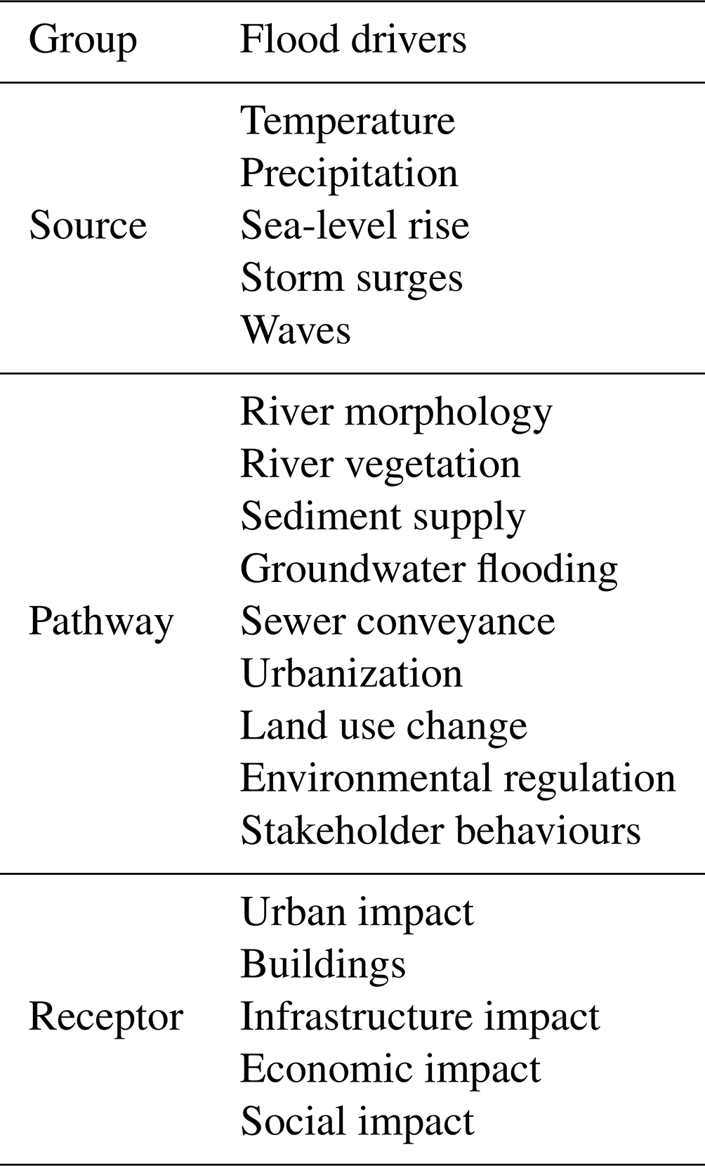
To have a better understanding of flood risk reduction intervention action, flood risk drivers are defined as an event that can change the condition of a flooding system and are characterized by using the source–pathway–receptor (SPR) paradigm (Evans et al., 2006). A flood source is determined as any event or condition that may cause flooding due to hydrometeorological conditions (e.g. extreme rainfall, sea-level rise), while pathways are a mechanism to transfer floodwaters to the locations where they may impact receptors, and receptors are people and built environments that may be impacted by flooding.
Based on previous works (Evans et al., 2008; O'Donnell and Thorne, 2020), a source–pathway–receptor (SPR) river flood driver framework is shown in Table 1. There are five drivers identified as flood sources, such as temperature, precipitation, sea-level rise, storm surges, and waves. Nine flood drivers are categorized as flood pathways; they are river morphology, river vegetation, sediment supply, groundwater flooding, sewer conveyance, urbanization, land use change, environmental regulation, and stakeholder behaviours. The other five drivers are defined as flood receptors, i.e. urban impact, buildings, infrastructure impact, economic impact, and social impact.
Table 1Source–pathway–receptor (SPR) framework for the transboundary river basin.
Extreme precipitation is known to significantly affect floods in many metropolitan areas of Indonesia, including floods in Greater Jakarta (Mishra et al., 2018). Sudden changes in extreme precipitation in a short time span, which lead to an increase in water volume, intensity, duration, and locations affected, may cause severe flooding (O'Donnell and Thorne, 2020). The issue of transboundary river floods is that floods occur not only due to upstream precipitation but also due to downstream rainfall. In many cases, according to rainfall spatial distribution data, most of the metropolitan floods, including Greater Jakarta floods, were caused by evenly distributed rainfall along the Ciliwung River basin (Farid et al., 2021). It is understood that fluvial floods occur when rivers do not have sufficient capacity to pass flow rates from upstream to downstream areas (Asdak, 1995). The narrowing of the river capacity is mainly due to sedimentation and waste, as well as the construction of settlements on uncontrolled riverbanks. Reducing river sedimentation has been done by lowering upstream and midstream river erosion by lowering river flow rate through the construction of a humanmade lake, dam, and canal. For example, several humanmade lakes and dams have been constructed in the upstream area of Ciliwung River, such as Bogor Regency and the Depok area, to control flood peak discharge in the midstream and downstream areas of the Ciliwung River basin (Nugraheni et al., 2020).
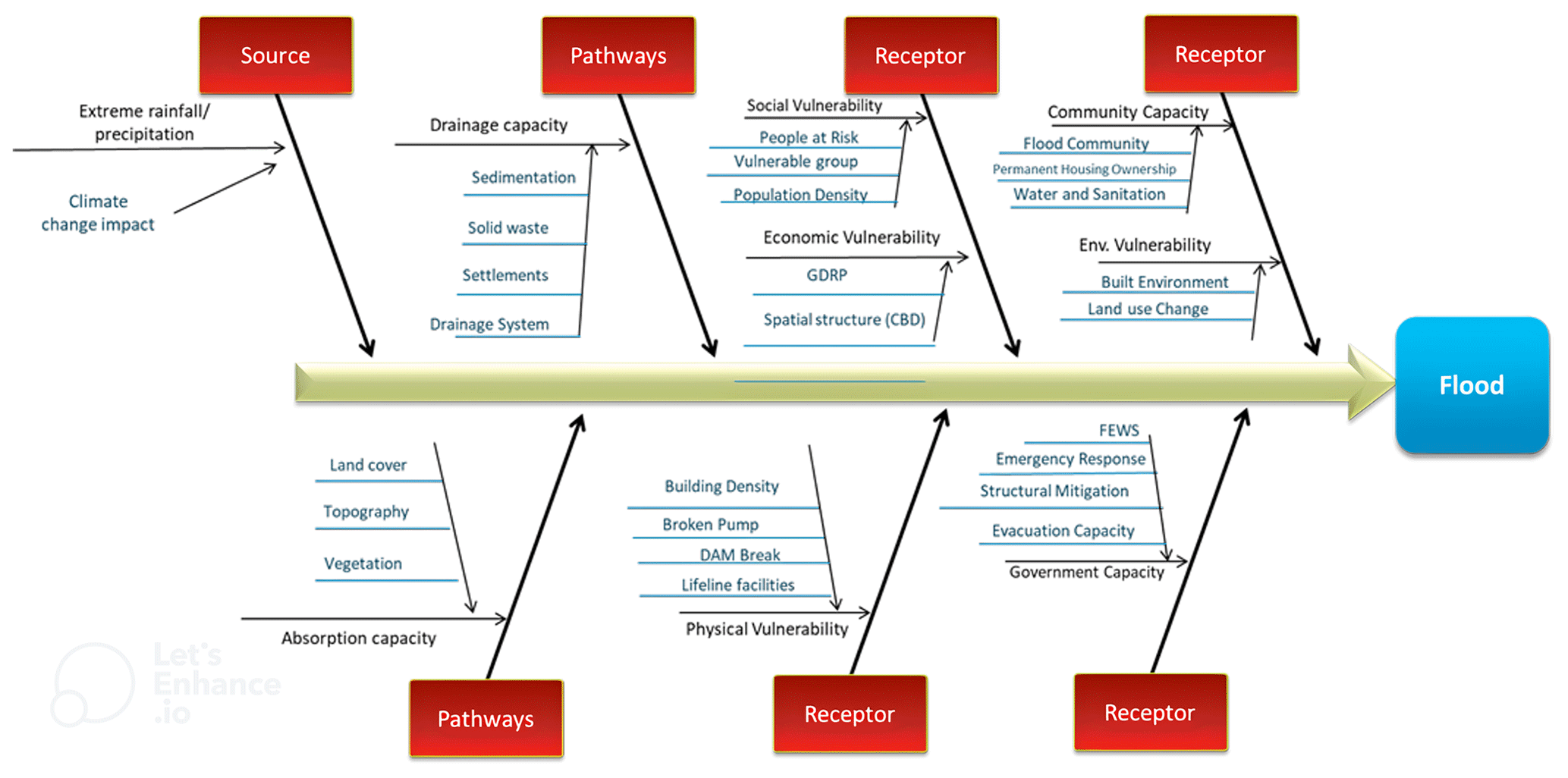
To have better visualization, this study has preliminarily attempted to describe the SPR flood risk driver framework in a fishbone diagram; see Fig. 1 (Rahayu, 2022a). This diagram was developed by integrating the hazard, vulnerability, and capacity approach into SPR. The source is defined as flood hazard, i.e. extreme precipitation and climate change impact; pathway is defined as drainage and absorption capacity; and receptor is defined as social and physical vulnerabilities, as well as community and government capacities.
2.2 MICMAC
Prioritizing the challenges in transboundary river flood risk can be done through many approaches. The Pareto principle is commonly used for classification; i.e. 20 % of the population possesses 80 % of the wealth. Prioritization is done using the Pareto chart, i.e. a simple block diagram displaying the relative degree of importance of several different attributes in descending order. Hereby, the top 20 % of the population is believed to have influence on the attributes of 80 % of the population (Grosfeld-Nir et al., 2007). Moreover, Pareto efficiency has been used for climate trade policies and border tax adjustments (Keen and Kotsogiannis, 2014). The weakness of these approaches is when the Pareto chart of the data has an almost flat distribution. The Pareto approach will be very useful if we have a steep descendent curve distribution, where 20 %–80 % can be allocated based on the frequency distribution. Others have used a power–interest matrix, a new approach for prioritizing role-based stakeholder engagement (Horton and Pilkington, 2014; Dutta and Das, 2020), mapping the variables in four quadrants. The first quadrant is the key players with high power and high interest. The second quadrant is those that are kept informed, with low power but high interest. The third quadrant is those that require minimal effort, with low power and low interest. The fourth quadrant is those that are kept satisfied, with high power and low interest.
However, several studies have used the power–dependence approach, a very simple and useful approach for classifying and structuring the priority of flood drivers. A powerful tool used to identify driving power (influential) and dependence power (influenced) is a quantitative method called Matrice d'Impacts Croisés Multiplication Appliquée á un Classement (MICMAC). Both Attri et al. (2013) and Saxena et al. (1990) agree that MICMAC analysis is a significant tool for in-depth analysis of a system. The method defines the level of power and dependency by analysing the interrelation among the drivers. MICMAC analysis is carried out to scrutinize the impact of the driving power and dependency power on the quadrant factors (Ansari et al., 2013). Placing the driving power on the x axis and dependency power on the y axis, the factors are classified into four quadrants (groups), i.e. independent, linkage, autonomous, and dependent groups (Duperrin and Godet, 1973; Jharkharia and Shankar, 2005).
The independent group consists of drivers with strong driving power but low dependence power. These driving variables are often called key driving variables and are rarely influenced by other drivers but strongly influence other groups. The linkage group consists of the driving variables characterized by both high driving and high dependency power. Variables within the linkage group influence other groups and are influenced by them. This group, called relay variables, represents variables that have strong interconnections with and mutual dependencies on variables in other quadrants. Meanwhile, the autonomous group, often called autonomous variables, consists of driving variables characterized by extremely low driving power while also having low dependency power on factors in other groups. They are self-contained and do not significantly drive or depend on other quadrants. Lastly, the dependent group, called dependent variables, consists of driving variables characterized by low driving ability but high reliance power on other groups. These drivers rely heavily on other drivers, and any action taken by other drivers will have an impact on the dependent drivers.
In disaster risk reduction, MICMAC analysis has previously been used to discover important factors in a resilient humanitarian supply chain that emerge during post-disasters (Singh et al., 2018). This study's findings will help government agencies and policymakers make proper strategic decisions to increase resilience. Further, it assists emerging countries in minimizing massive losses and improving economic growth for the benefit of society. However, up to the present day, only a few studies on discovering key flood drivers using the MICMAC method have been published. For example, Ariyani et al. (2022) have used the MICMAC model to identify the contributing factors influencing flood disaster in the Ciliwung watershed using influence–dependence criteria. The factors were identified using a hazard vulnerability capacity framework; however, the targeted respondents were very limited and not comprehensively represented by the flood-related institutions of the transboundary administrative jurisdiction, only featuring one provincial government of Jakarta, two national institutions, and various experts for the remainder of the study.
Meanwhile, Sharma and Sharma (2019) attempted to conduct identification and prioritization of flood conditioning factors using the interpretive structural modelling (ISM) and MICMAC techniques. A total of 11 flood conditioning factors are identified based on literature reviews and the Delphi method for expert judgement. The credibility of the information in the study will depend on the selected experts.
To improve the deficiency in the above studies, this study uses the MICMAC analysis model to prioritize flood risk drivers to obtain the key flood drivers, which will be very useful for the development of a collective action plan in disaster risk reduction intervention among transboundary stakeholders. Details of the study are described in the “Research methodology” section below.
2.3 Research methodology
This study emphasized the importance of recognizing transboundary flood risk drivers and classifying those drivers to gain insight into the priorities of drivers to structure the priorities of disaster risk reduction intervention. To exemplify this theoretical consideration the study used the Ciliwung River basin as the study location.
To have more realistic transboundary flood risk drivers/challenges, preliminary identification of all transboundary challenges was obtained through literature and document reviews, which were combined by field observation, from the perspective of upstream, midstream, and downstream flood issues and challenges. These challenges are also called flood risk drivers in this study and are used interchangeably according to the context of the discussion. Results of the preliminary identification are shown in the source–pathway–receptor framework in Table 1 and in the fishbone diagram in Fig. 1.
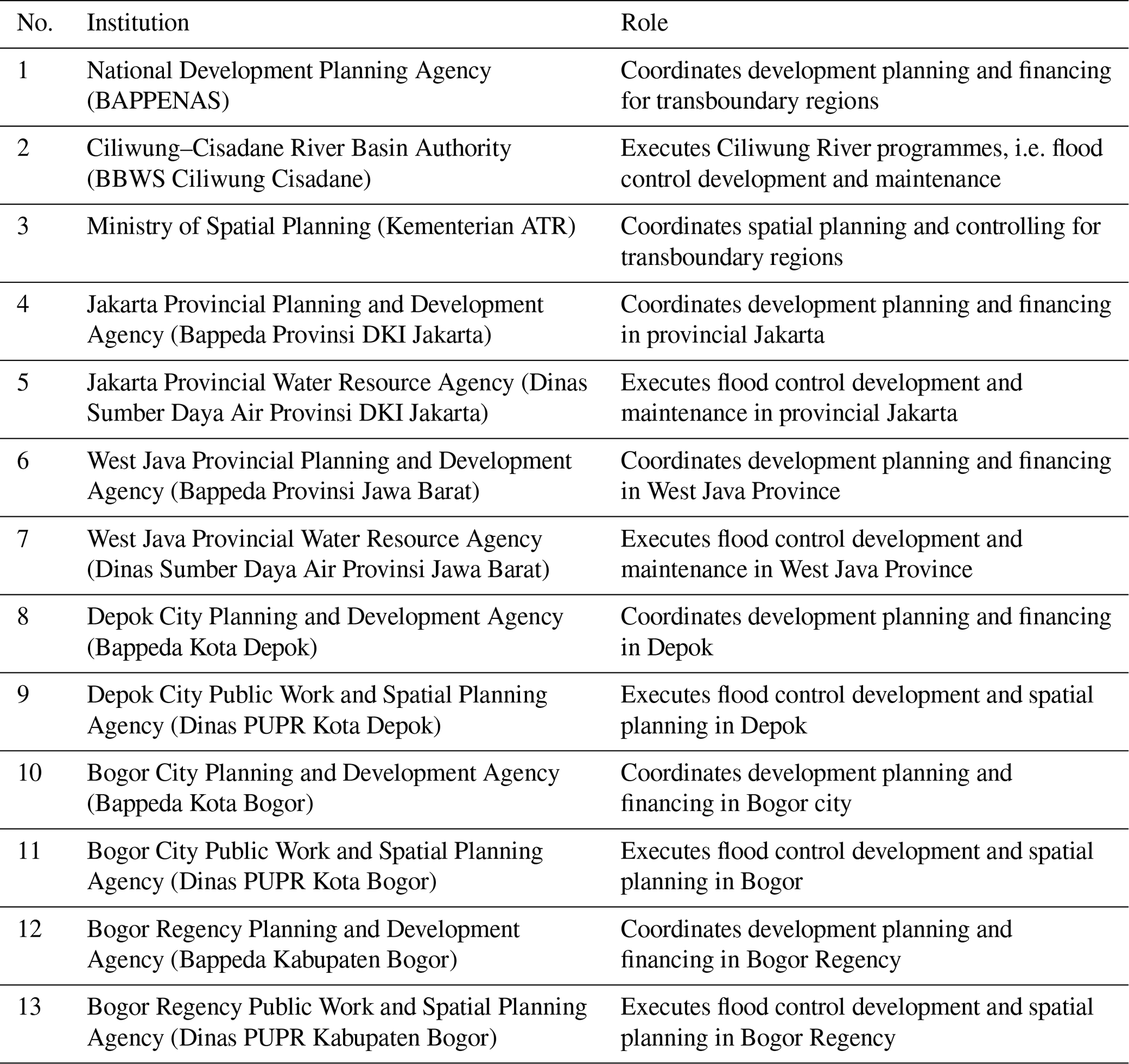
To develop a realistic flood risk driver framework, a focus group discussion (FGD) among transboundary stakeholders/government institutions involved in Ciliwung River's management was conducted. A total of 13 actors/stakeholders from national and transboundary provinces, cities, and regencies of the Ciliwung River basin actively participated in the FGD; the name of the stakeholder institutions can be seen in Table 2.
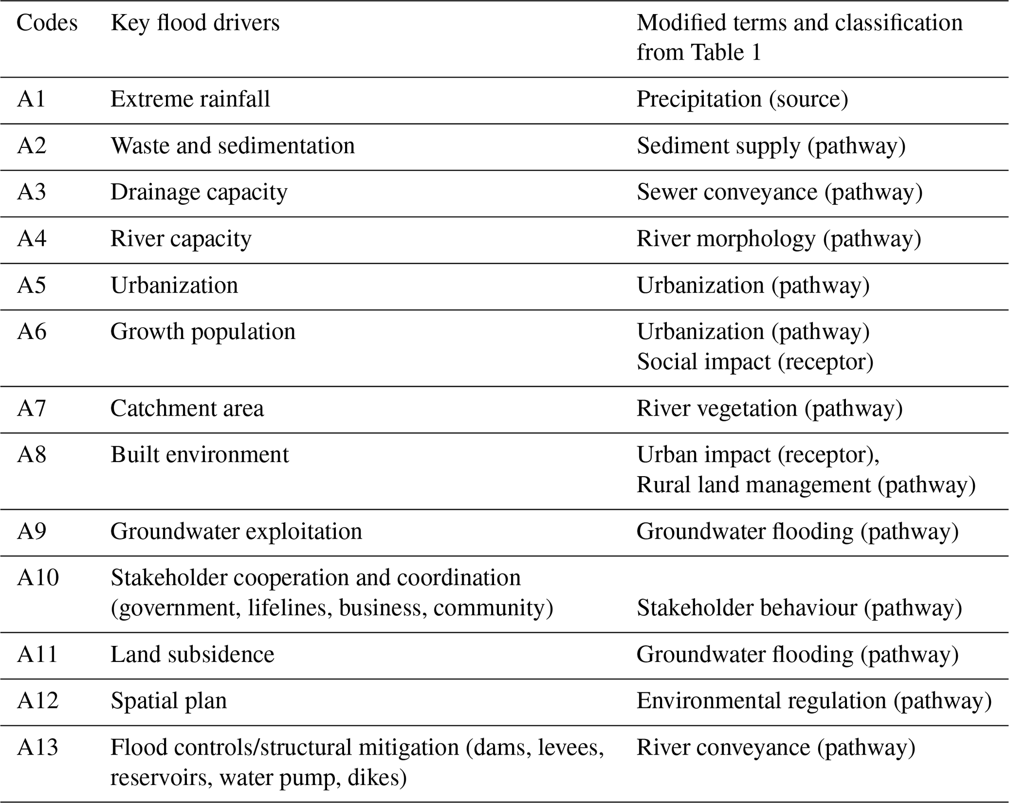
The FGD resulted in the final improved framework with 13 important flood drivers, as also shown in Table 3. This framework is used as the basis for in-depth interview using the four key questions below:
-
What are the significant issues related to each driver?
-
What is the relationship between the influence and dependence criteria among drivers from the perspective of flood disaster risk reduction intervention?
-
Who are involved in implementing the flood disaster risk reduction intervention for each driver?
-
What are the potential effects of the dependence criteria of each driver?
2.4 Structural self-interaction matrix and initial reachability matrix for MICMAC analysis
To recognize the challenges and complexity of transboundary management in flood risk reduction, this study involves a qualitative and quantitative approach using primary data from a stakeholder focus group discussion, in-depth interviews, and field observations. The 2019 focus group discussion on mitigating hydrometeorological hazard impacts through transboundary river management in the Ciliwung River basin aimed for sensitization of stakeholders regarding the issues of transboundary challenges in flood risk management, which has helped to build trust and forge a potential pathway to impact flood risk management through river basin management policy. The interviews and field observations were conducted from September to December 2020; during this period, there were several Ciliwung flood events that occurred in Greater Jakarta, making the obtained data more relevant and up to date. Face-to-face and online interviews are used for the interview methods as a result of Indonesia's large-scale social restrictions due to the Covid-19 pandemic. Both kinds of interview methods have the same quality of content.
To have reliable results in the case of transboundary river management, the interviews included multi-level governments, i.e. national, provincial, and city/regency governments, along the Ciliwung River basin. The role of river-basin-related institutions could be divided as follows (Dewi and Ast, 2017): first is the institutions with a main role in the planning process at each of the national, provincial, and city/regency levels; second is the institutions responsible for the implementation process of flood management projects, also at each of the national, provincial, and city/regency levels; and third is the institutions that have the power of coordination. Based on these three criteria, 13 experts related to Ciliwung River floods from different levels and regions are selected as the target respondents; see also Table 2.
Given the final set of flood risk drivers as presented in Table 3, all experts as listed in Table 2 were asked to identify the key flood risk drivers of Ciliwung River floods and its interrelations with justifications. They were also asked to explain the actual condition of each driver based on their empirical knowledge and scope of work. Grounded theory, as the qualitative method, is then used to convert experts' statements into codes. The grounded theory method involves gathering and analysing data to generate a middle-range theory (Charmaz, 1995). Analytic processes consist of data coding, developing, and checking, as well as integrating theoretical categories and constructing analytic narratives (Glaser and Strauss, 2017).
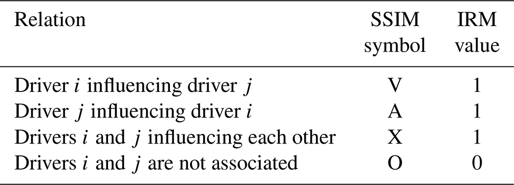
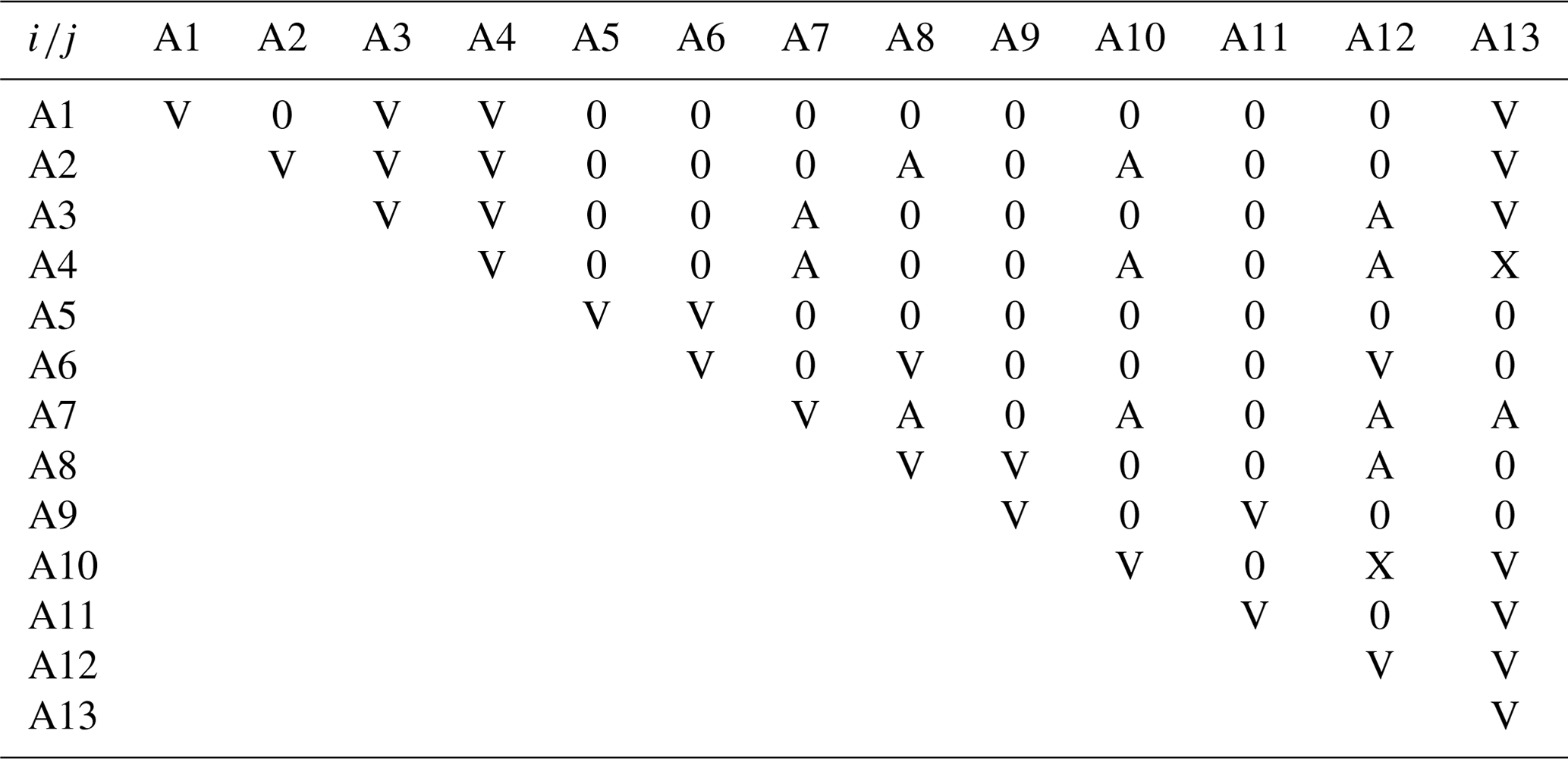
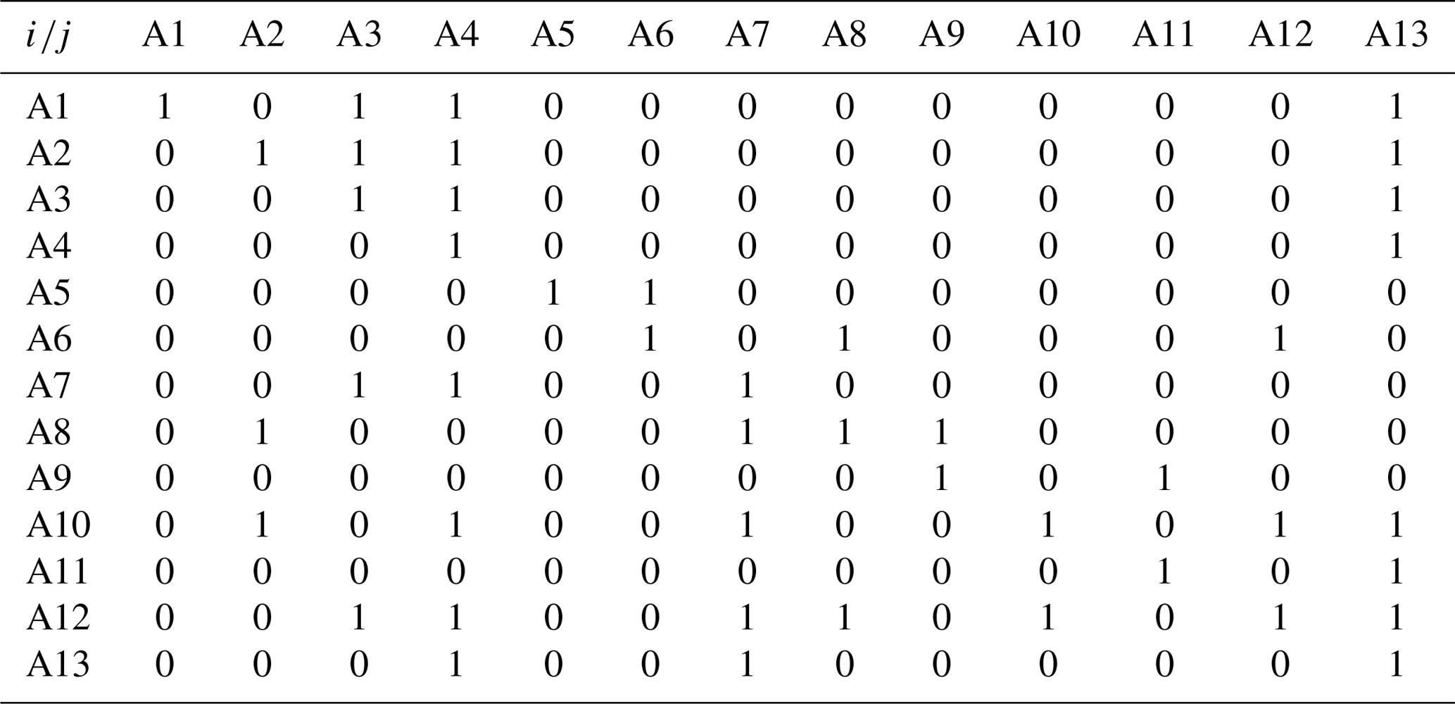
Through these in-depth interviews with targeted stakeholders, the experts' judgement is used to establish a conceptual link among the drivers, where these drivers could also be impactful to each other. The drivers' relative responses were obtained by calculating the collected opinion in the interviews. The expert judgement assists in depicting a suitable interaction between these drivers. These variables' conceptual link is characterized using a pairwise relationship as either influencing other drivers or being influenced by other drivers. Using VAXO symbols, four symbols which have been defined to demonstrate the linkage between i and j drivers, the expert judgement matrix called the structural self-interaction matrix (SSIM) was mapped to associate it with 13 drivers. In Table 4, SSIM and initial reachability matrix (IRM) values show the VAXO symbols. Symbol V represents driver i influencing driver j, symbol A shows driver j influencing driver i, symbol X shows driver i and j influencing each other, and symbol O shows driver i and j are not associated. The SSIM developed with the help of the experts' judgement can be seen in Table 5. Moreover, Table 4 also shows the VAXO rule for converting SSIM values into IRM values to structure the IRM shown in Table 6 as the data set input for the MICMAC model analysis. Then, output of MICMAC analysis showing the classification of the drivers into four quadrants, i.e. independent, linkage, autonomous, and dependents variables, is shown; see also Fig. 4. This is then followed with a discussion using more information from the stakeholders during interviews.
3.1 Ciliwung River basin and Jakarta metropolitan development
The Jakarta metropolitan area, known as Greater Jakarta, is an agglomeration of the cities of Jakarta–Bogor–Depok–Tangerang–Bekasi. This metropolitan is one of the most appealing locations for both domestic and foreign investment, with a large number of entrepreneurs and skilled labourers, as well as easy access to decision-makers (Firman, 1998). To compare, as of 2023, the Tokyo metropolitan area in Japan was the world's largest urban agglomeration, with 36.57 million people living within a 7693 km2 area, while the Jakarta metropolitan area ranked second with 34 million people living within a 7315 km2 area (Global megacity populations, 2023; Rahayu, 2022a). According to Euromonitor International, the Jakarta metropolitan area will become the most prominent megacity globally, with an estimated population of 35.6 million by 2030 (Dyvik, 2023). As defined by the UN, a megacity is a city with a population of more than 10 million.
The Jakarta metropolitan area is geographically crossed by 13 river systems, including Ciliwung River, which has the longest and biggest river basin. According to presidential decree number , the Ciliwung River basin area is 140 km long with nearly 438 km2 catchment area crossing Jakarta Province, three major cities, and one regency in the West Java Province, as shown in Fig. 2a. Meanwhile, Fig. 2b shows the designated land use for the Ciliwung River basin, which is divided into three zones, i.e. upstream, midstream, and downstream. Bogor Regency and the city of Bogor at the upstream zone are concerned with conservation and water resource areas, while the city of Depok at the midstream zone is concerned with buffer zone and catchment areas. The Jakarta Province at the downstream zone is concerned with cultivation and coastal protection areas. However, due to massive development of each city/regency and province, this land use zonation has often been violated.
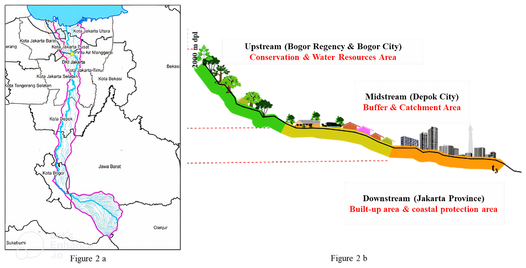
Figure 2Land use in the Ciliwung River basin (source: FGD, 2020, in Rahayu, 2022b).
Being situated in a watershed, the Greater Jakarta area is exposed to hydrometeorological hazards, such as urban floods. Severe floods due to the Ciliwung River's overflow have been recorded in 1996, 2002, 2007, 2012, and 2013 (Dewi and Ast, 2017), while the most severe flood took place in early 2020 due to both fluvial and pluvial floods. A total of 13 administrative units in the Jakarta, Banten, and West Java provinces were flooded, causing an estimated loss of around IDR 5.2 trillion during the 2020 event. The coastal region of Greater Jakarta is also exposed to frequent tidal floods.
From a flood vulnerability perspective, approximately 25 million people live in the Ciliwung River basin (CRB), with a growth rate of around 1.4 %. The flood-prone areas are primarily located in the densely populated Jakarta Province (DKI Jakarta), with about 28 818 households in 2009 (Rahayu and Nasu, 2010) and about 34 051 households by 2021 (Rahayu, 2022a).
Several factors have been attributed to the increased magnitude of flood impacts in Greater Jakarta over the past few decades, including precipitation, land use change, sea-level rise, and land subsidence (Budiyono et al., 2016). However, massive urbanization in Jakarta between 1995–2014 has significantly decreased runoff regulation, green spaces, and bodies of water; has affected landscape pattern changes (Maheng et al., 2021); and has strongly influenced spatial characteristics, such as industrial parks, mixed-use new towns and large-scale residential areas, and shopping centres (Firman and Fahmi, 2017). As identified by a previous study (Silver, 2007), the Jakarta land use change was initiated in the early 1980s, where many agricultural and forest areas in suburban Jakarta were transformed into large-scale subdivisions and new towns. More than 30 large new suburban towns and industrial parks were built in the peripheries of Jakarta between 1990 and 2010, with an average size of 500 to 30 000 ha (Firman, 2014). As a consequence of these vast peri-urban developments, a massive conversion of water catchment areas, wetlands, and green areas has occurred, which has also led to an increased flood threat to Jakarta. Further, the urbanization was clearly seen to increase not only the intensity and volume of inundations, but also the runoff and river flow discharges, which all led to the increase in flood threat (Priyambodoho et al., 2022). Thus, to identify flood risk drivers we must address spatial scales from upstream to downstream areas (Dawson et al., 2009). Figure 3 shows the rapid land use change in the Ciliwung River basin in 2 decades, from 2000 to 2017, with an approximately 17.18 % rate of change in 2 decades. Meanwhile, the proportion of built-up area reached 58.96 % of the total basin by 2017.
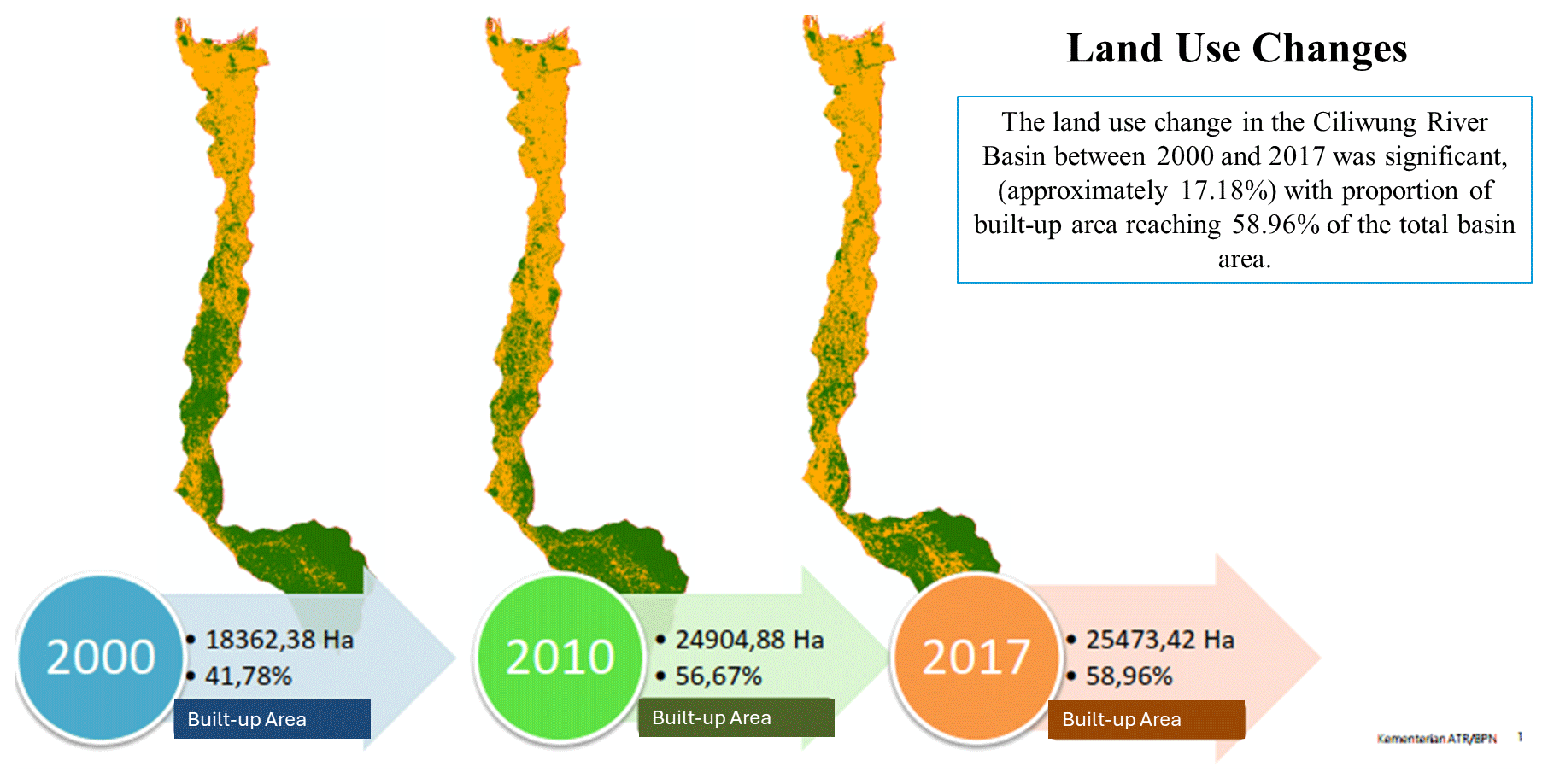
Figure 3The Ciliwung River basin land use change (source: ATR, 2020, in Rahayu, 2022a).
In the last 2 decades, several scholars have studied flood drivers in the Ciliwung River basin. For instance, Texier (2008) identified the root causes of disaster vulnerability in the Jakarta Province, Emam et al. (2016) studied the effect of climate and land use change in the upper Ciliwung River, both Asdak et al. (2018) and Texier (2008) analysed problems in downstream flooding, and Sagala et al. (2013) highlighted Greater Jakarta flood vulnerability. Of these studies, however, none discussed the issues of transboundary flood risk drivers and responsibility sharing, and none mentioned which drivers are the most critical for transboundary flood risk management.
The Ciliwung River Basin Authority (BBWS-CC), under the Ministry of Public Works, bears responsibility for Ciliwung River basin management. However, the transboundary river flood itself becomes a major disaster issue for all adjacent administrative jurisdictions, i.e. Jakarta Province, West Java Province, Depok, Bogor, and Bogor Regency. This leads to the complexity in transboundary flood risk drivers at these regions of the river basin, with many aspects consequently forming part of the megapolitan development. Flood risk managed by a single national authority is indeed complicated enough and becomes much more complex when dealing with a transboundary river. However, it is the responsibility of local government to protect the people at risk of disaster (Government of Republic Indonesia Law No. 24/2007 regarding disaster management, 2007; Government of Republic Indonesia Law No. 23/2014 regarding Local Government, 2014).
3.2 Transboundary flood risk driver framework for CRB
Jakarta has experienced more severe floods compared to other regions due to its geographical position downstream. Despite extensive efforts by the Dutch and Indonesian governments, Jakarta is still prone to flooding because of its location in a major river delta (Asdak et al., 2018). This was worsened by land subsidence issues; about 40 % of areas in Jakarta are a few metres below sea level, with an estimated increase in metres below sea level of 1 to 15 cm yr−1 both spatially and temporally (Latief et al., 2018).
The existing Jakarta flood control system was developed based on Van Breen's (1973) concept, in which the overflow rainwater from outside Jakarta is redirected via flood canals (west flood canals and east flood canals) that circle Jakarta. Runoff within the city of Jakarta is discharged through a local drainage system by gravity and discarded with a polder system, including a water pump and pond retention in low areas (Kusuma et al., 2010).
Apart from natural causes, rapid urbanization and massive population growth have led to an increase in the susceptibility and vulnerability to Jakarta floods (Rahayu and Nasu, 2010). The rapid growth in urban sprawl (Maheng et al., 2021, Firman and Fahmi, 2017) has caused massive land conversion from the catchment area to the built environment. A change in land use over time can have significant effects on runoff (Mishra et al., 2018). Uncontrolled land use change due to poor spatial planning along the Ciliwung River basin causes the flooding to become more complicated to handle (Asdak et al., 2018). To control current developments and minimize future risks, strong governance with good long-term spatial planning is needed (Rahayu et al., 2019). It is expected that spatial planning will contribute to flood mitigation in floodplain areas (White and Howe, 2002; White and Richards, 2007) by regulating the land use types, spatial patterns, development scales, and physical structure designs. Spatial planning can affect the likelihood of floods and its consequential damage (Neuvel and van den Brink, 2009; White and Richards, 2007).
The emergence of law 23/2014 regarding local government resulted in correct and obligatory sharing between national and local governments, also known as decentralization. Decentralization and power sharing have expanded disaster management responsibility at local levels, with national policy impacting it (Sunarharum et al., 2021). Since the Ciliwung River basin flows along transboundary regions, national, provincial, and city/regency governments along the Ciliwung River basin are therefore responsible for flood risk management as well. While governments may be able to mitigate flood risk, communities, especially those affected by floods, must be included in flood risk management decisions (Faulkner et al., 2007). However, as flood risk management involves various stakeholders (i.e. governments, communities, academics, media, and private companies) and multiple objectives, conflicts may also arise. Up until recently, the coordination among stakeholders in the Ciliwung River basin had still encountered many challenges and as a result affected decision-making (Sunarharum et al., 2021).
The Ministry of Public Works regulation number 13/PRT/M/2006 regarding river management has defined the Ciliwung River as a transboundary river that crosses two provinces and four cities/regencies and is controlled by the national government, i.e. the Ciliwung–Cisadane River Basin Authority (BBWS CC), in collaboration with local stakeholders. Understanding transboundary management in flood risk reduction is very critical.
Based on input from the stakeholder focus group discussion (FGD) conducted by the authors on 26 September 2019 in collaboration with the National Planning Agency (Bappenas), the preliminary framework of Ciliwung River flood drivers shown in Table 1 and combined with Fig. 1 was refined with a few modifications in terms of the discussion and recommendation of the FGD. The FGD was attended by 13 institutions directly and indirectly involved in Ciliwung flood management, from national, provincial, and local government. The result of the improved Ciliwung flood risk driver framework is shown in Table 3 with 13 independent flood driver variables.
The results of the MICMAC model are shown in Fig. 4. The 13 flood drivers are divided into four quadrants, i.e. independent, linkage, autonomous, and dependent groups. Through this analysis, two flood drivers, i.e. spatial plan (A12) and stakeholder cooperation and coordination (A10), are classified as independent drivers, which are key flood risk drivers with the most powerful drivers in the Ciliwung River basin. The independent drivers are characterized by having the highest driving power and the lowest dependency power. They exert a significant influence on other drivers at the other two quadrants, both dependent and autonomous drivers. In the overall system of transboundary Ciliwung River flood management, these two independent drivers will have an important role, especially for collective actions in flood disaster risk reduction. The intervention in these two drivers will have the highest impact on the system. However, this study found no drivers fall into the linkage groups. The linkage drivers should be the intermediate variables in the system, to link all drivers from the other quadrants. This driver is basically a variable that has a big impact on the system, but at the same time, it also has a high dependence on other drivers from other groups. Since there are no linkage variables found in the system, this means that all the stated variables in the system are stable.
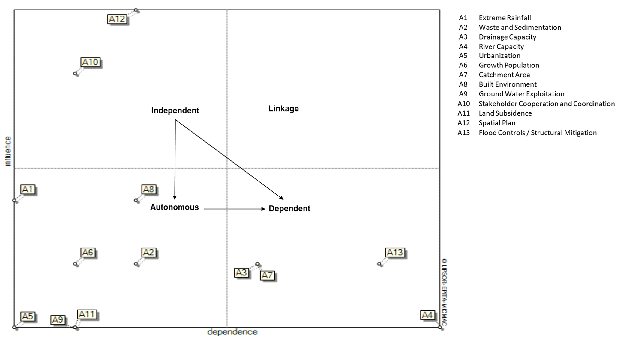
A total of seven flood drivers are classified as autonomous drivers. They are extreme rainfall (A1), built environment (A8), growth population (A6), waste and sedimentation (A2), urbanization (A5), groundwater exploitation (A9), and land subsidence (A11). These seven autonomous drivers do not have any impact on other drivers. They are also characterized by extremely low driving power and low dependency on other drivers' groups, and they are more self-contained. However, the extreme rainfall (A1) driver shows unique value. It is located closer to the independent group; it has a relatively high driving power in its quadrant even though it has low dependent power. Thus, this flood driver is discussed further in the next section.
The rest of the flood drivers, which show the lowest driving ability and the highest reliance on other groups, are categorized in the dependent group. The dependent variable is a variable that depends a lot on other variables but has a small impact on the other variables. The dependent flood drivers are drainage capacity (A3), catchment area (A7), flood control and structural mitigation (A13), and river capacity (A4). These variables are the weakest drivers in the system, relying heavily on other drivers. Any action taken by other drivers will have an impact on these dependence drivers. River capacity appears to be the most dependent driver, indicating the end of the flood driver chain in the overall system of transboundary Ciliwung River flood management.
Through MICMAC model analysis, this study has been able to unveil two significant key flood drivers, i.e. spatial planning and stakeholders' cooperation and coordination. These key flood drivers cover the critical issues and challenges of Ciliwung flood risk governance in reducing/managing the Ciliwung River flood risk as well as achieving a sustainable catchment area. Referring to the source–pathway–receptor model in Table 3, it is found that in the case of Ciliwung River flood risk management, both key pathways, such as environmental regulation through spatial planning and stakeholder behaviour in collective action for flood disaster risk reduction, have the biggest influence on the set of flood risk drivers. Surprisingly, this study was also able to unveil that most dependence drivers are found to be related with the catchment area and capacity to channel out the flood water, such as drainage capacity, river capacity, and flood control. Any action taken on other drivers will have a significant impact on these dependence drivers, especially intervention action in spatial planning and stakeholders' cooperation and coordination. Further, the two highest key flood drivers, i.e. spatial planning and stakeholders' cooperation and coordination; the moderately high key flood driver, i.e. extreme rainfall; and the most dependent flood drivers, i.e. flood controls, are discussed.
The findings of this study could be used as inputs for other cities/metropolitan areas which have similar challenges related to transboundary river flood management.
4.1 Spatial plan
A holistic approach is needed in the development of flood risk management, covering the upstream, midstream, and downstream areas. Controlling the river basin development through integrated spatial planning from upstream, midstream, and downstream areas is necessary to reduce flood risk in the river basin. Spatial planning is a system concerned with long- or medium-term objectives and strategies for the region's development and consists of planning processes, space utilization, and control of space utilization. The spatial plan is basically composed of the spatial structure and spatial pattern. The spatial structure plans residential and business centres and all supporting infrastructure networks and facilities for related socioeconomic activities of the community. The spatial pattern distributes space allocation by considering protection functions as well as cultivation and/or development functions. Since Ciliwung River is one of the longest river basins passing through two provinces and five regencies/cities, the role of integrated transboundary spatial planning becomes very critical from the perspective of harmonizing ego sectoral and ego area jurisdictions, especially in enforcing transboundary environmental regulations. This is in line with the findings of the study that show spatial plan (A12) and stakeholder cooperation and coordination (A10) are the most critical flood risk drivers in Ciliwung River basin management. Both key flood drivers are independent drivers having the most powerful influence on other key flood drivers.
Most flood risk reduction regulations are included in each city/regency as well as provincial spatial plans, such as land use regulation, structural mitigation development, catchment area preservation, and river maintenance. The integration of these disaster risk reduction countermeasures into spatial planning regulations has been studied by several works. For example, flood risk avoidance is often used for controlling spatial development in floodplain areas, including relocation plans (Kang et al., 2009), while flood risk defence is used for protecting the region from floodwater by building river dikes (Voorendt, 2017). Meanwhile, flood risk mitigation is used for reducing flood impact loss by structural mitigation or nature-based solutions for flood detention (Sayers et al., 2013), flood retention (Wingfield et al., 2019), and flood passages (Kang et al., 2009). Last but not least, flood risk preparedness is used for evacuation plans, and flood risk recovery is used for developing a post-recovery plan and critical infrastructure protection (Meng et al., 2022; Sayers et al., 2013).
In the case of Ciliwung River, these city/regency and provincial spatial plans are often developed only to suit the area's own needs and objectives, without considering broader needs, such as regional flood risk management. To bridge the transboundary issues and challenges in spatial planning as tools for flood risk management, the Ministry of Spatial Planning established the Greater Jakarta Spatial Plan in government law number 60/2020 to incorporate all these related local and provincial spatial plans. This Greater Jakarta Spatial Plan is expected to function as a transboundary spatial plan. However, until now, it has not been fully enforced yet in water resource and flood risk river management.
Further, the Ciliwung–Cisadane River Basin Agency has formulated a plan in the Ministry of Public Works decree no. 26/KPTS/M/2015 regarding the integration of the Ciliwung and Cisadane River basins, which also means combining both Ciliwung–Cisadane River management programmes. During the FGD, the Ciliwung–Cisadane River Basin Authority (BBWS Ciliwung Cisadane) stated that there were massive land use changes upstream of the river basin, where this became the main flood driver, and that the flood itself was worsened by the extreme rainfall. The Ministry of Environment and Forestry (KLHK) under the Agency for Citarum–Ciliwung River Basin Management (Balai Pengelolaan Daerah Aliran Sungai Citarum–Ciliwung, BPDAS) assumed that land use and land cover changes have become the primary contributor to Ciliwung River basin floods. For example, the deforestation of the upstream Ciliwung River basin may cause flooding midstream and downstream. Thus, the spatial plan needs to consider the land use change as well as the flood risk reduction. The National Planning and Development Agency (BAPPENAS) said that starting from 2010, the average runoff coefficient has been recalculated due to land use change. There was an increase of up to 0.4 and 0.5 in 2014. Meanwhile, the West Java Planning and Development Agency (Bappeda Jabar) assumed that the development in the catchment area should consider transboundary commitment for the rehabilitation of conservation and protected areas. The more land use changes occur, the less water catchment areas remain, leading to floods. During the FGD, several experts judged that development control in the Ciliwung River basin appeared to be weak as land use changes emerged upstream, midstream, and downstream. Urban and regional development has increasingly not considered catchment area provision over time due to economic pressure. Although spatial plans have been created on many levels, development control remains powerless to retain the catchment area. Some upstream regions have been turned into residences, hotels, villas, and restaurants, resulting in increased water runoff, but in Jakarta, new settlements are created without regard for spatial planning, affecting water absorption.
It appears from the results of the MICMAC model that spatial planning has significantly affected drainage capacity, river capacity, catchment area, built environment, stakeholder cooperation, and flood control development; thus, improving, strengthening, and integrating the spatial plan related to the Ciliwung River basin of the Jakarta Province, Depok, Bogor, and Bogor Regency is the main priority in order to have better results in overall sustainable flood risk management. Land use plans are supposed to substantially impact the basin's development (Wang et al., 2010). Therefore, spatial planning is a critical tool for reducing flood risk (Neuvel and van den Brink, 2009). Budiyono et al. (2016) investigated the great potential of urban planning to mitigate flood risk. They demonstrate that if Jakarta's land use follows the 2030 spatial plan, flood risk will be reduced by 12 %. This highlights the great potential of land use planning for flood risk reduction.
Having a solid and integrated spatial plan is not enough to reduce flood risk unless it is followed by robust development control. Strict development control must be applied at the basin level, which means not only in the Jakarta Province but also in Depok, Bogor, and Bogor Regency as part of the Ciliwung River basin regions. Development control regulation in the Ciliwung River basin may differ from upstream and downstream municipalities depending on physical, environmental, and institutional characteristics. Development control in the upstream area mainly aims to preserve the catchment area, while in the downstream area, it primarily aims to prevent groundwater exploitation and higher physical vulnerability. The national government, along with the local government, must create efficient instruments for development control, while the local government itself must carry out strict surveillance and give penalties for all development violations.
To strengthen development control in the Ciliwung River basin, a holistic regulation regarding development control (mechanism, instrument, zoning technique, and executor (i.e. task force)) on the Ciliwung River basin level must be legalized as a national policy. The president should make this a national priority programme, considering the areas impacted and the number of losses that the Ciliwung River floods have generated. So far, an integrated development control policy in the Ciliwung River basin has not been developed yet; therefore, the Greater Jakarta Spatial Plan (president decree number 60/2020) is expected to be an umbrella of the transboundary spatial plan for the Ciliwung–Cisadane River basin management programme (Ministry of Public Works decree no. 26/KPTS/M/2015).
4.2 Stakeholder coordination and cooperation
As the second critical key flood driver, stakeholder cooperation and coordination (A10) plays an important role in transboundary Ciliwung River basin management. It is the independent drivers which have the most powerful influence on other key flood drivers. River basin sustainable development and management need to consider the basin as a whole, with multiple water–ecosystem–economy interactions from the upstream, midstream, and downstream areas (Cheng et al., 2014). Lorenz et al. (2001) defined sustainable river basin management through an interaction model of social capital, human capital, natural capital, and humanmade capital. This model generated laws, regulations, and information flows for triple-helix stakeholders, i.e. governments, businesses, and communities.
Based on the interviews in this study, stakeholder cooperation and coordination among governments, communities, academics, lifelines, and businesses significantly affects other drivers, such as waste and sedimentation, river capacity, catchment area, built environment, groundwater exploitation, spatial and development plans, and flood controls. The imperative issue is the coordination and cooperation among governments. The transboundary governance forum for Ciliwung River basin management has been reformed many times. Two previous forums are the Ciliwung River basin forum in 2007, led alternately by the governor in the Ciliwung River basin, and the Ciliwung Water Resource Management Coordination Team in 2011, led alternately by each planning and development agency in the Ciliwung River basin. According to the experts' experience obtained during the FGD, the reformation keeps occurring due to the ineffectiveness of the forum mechanism, a powerless leader, and conflict of interest. There was no clear framework for the forum and no legal agreement about how coordination and cooperation among institutions should work. This eventually resulted in no clear action. Each institution merely understands its own jobs and pays attention to their interests or said sectoral egos. Moreover, there was no strong figure who could lead the forum.
Meanwhile, the Ministry of Environment and Forestry (KLHK) under the Agency for Citarum–Ciliwung River Basin Management (Balai Pengelolaan Daerah Aliran Sungai Citarum–Ciliwung, BPDAS) stated that Ciliwung River is very complex in its governance. The Jakarta provincial government's responsibility is at the downstream area, while the West Java provincial government's responsibility is at the upstream area only. The transboundary river management should have one leader. If the Ministry of Environment and Forestry (KLHK) takes the lead, it will be difficult to manage the inter- and cross-sectoral issues. For example, a good lesson was learned from the management of Citarum River, which was assigned to Citarum Harum and led by the national military based on the presidential decree. Thus, the Ciliwung River management needs to have a similar governance structure, since the existence of the Coordinating Board for Jakarta Metropolitan Area Development (BKSP Badan Kerja Sama Pembangunan) has not been optimal and sustainable.
To compare with the Brantas River basin transboundary governance in East Java, Indonesia, crossing several jurisdictional areas, there has been good water governance of the basin's development and management handled by the central government (Brantas River Basin Executing Agency (BRBEA), known as the Brantas Project – BP), in collaboration with state-owned enterprises, i.e. PT Indra Karya and PT Brantas Abipraya, since the beginning of the 1960s, with massive construction projects of eight large dams, six barrages, and rubber dams along the Brantas River for irrigation, hydropower, flood control, and recreation purposes (Roestamy and Fulazzaky, 2022). However, its main challenges are related to technical issues, institutional frameworks, and regulatory instruments to fulfil the needs of various stakeholders from various jurisdictional areas. Water resource law 7/2004 has formalized the paradigm shift from project-oriented to integrated river basin development and has moreover created and empowered the institutional framework. Therefore, by 2007, BRBEA had been fully taken over by national institutions in handling strategic issues of the Brantas River basin.
Meanwhile, the National Planning and Development Agency (BAPPENAS) said that the transboundary coordination function of Ciliwung River could be managed by the project management officer (PMO) of the Jakarta metropolitan area (Greater Jakarta), which will later be substituted by the Coordinating Board for Jakarta Metropolitan Area Development (BKSP) in coordinating the three provinces, i.e. Jakarta, West Java, and Banten. However, this seemed to be effective since there is no involvement of national government. In the future, it is expected that there will be a coordinating body led by the Ministry of Agrarian Affairs and Spatial Planning together with the Ministry of National Planning and Development Agency as the vice ministry, with its think tank at the existing Coordinating Board for Jakarta Metropolitan Area Development (BKSP).
However, difficulties may arise in their management and governance when dealing with transboundary river management. Several critical institutions are involved in flood risk reduction, i.e. governments at national, sub-national, and local levels; utility companies; private businesses; and community groups (Jha et al., 2012). Coordination is required both between actors at different authority levels (vertical coordination) and among actors within administrative boundaries (horizontal coordination).
Meanwhile, as transboundary river basin governments have many flood drivers to overcome, they must meet concrete criteria to have an appropriate plan for river basin management. Firstly, clear roles and responsibility sharing among river management institutions are essential for effective coordination (Jha et al., 2012). A negotiation procedure and coordination mechanism are required (Barbazza and Tello, 2014). Secondly, a coordination mechanism is also important to enhance information and data flows and coordinate decision-making and implementation. Thirdly, leadership and power to enforce coordination contribute to the fragmentation of the institutional arrangement (Brown, 2005). Therefore, efforts to establish a governance forum in the Ciliwung River basin must follow these three criteria to avoid ineffectiveness.
According to Millington (2006), there are two types of river basin forums. They are (1) the river basin coordinating committee and (2) the river basin commission. A river basin coordinating committee is formed for stable and mature river basin management. This model mainly relies on the fair cooperation and participation of its members. The committee has no executive authority and cannot override the member organization's tasks and operations. The coordinating committee is made up of major water-related agencies from each of the basin's states.
Further, when problems happen frequently, a river basin committee is formed. A basin commission is a more formalized group than a committee. It consists of a management board that establishes objectives, goals, policies, and strategic direction. The commission is supported by a technical office of water, natural resource, socioeconomic planning, and management experts, many of whom would be drawn from existing agencies in the basin. To offer ultimate power, a ministerial council could lead the commission, and the basin commission would then focus on strategic natural resource management of the rivers and catchments. The fact that Ciliwung River basin management still encounters conflict and is not stable in management attests to the river basin commission potentially being the best-fitting model for Ciliwung River basin governance.
4.3 Extreme rainfall
Extreme rainfall (A1) is acknowledged in this study as an autonomous driver with moderate driving power and the lowest dependency power. It is supposed to be characterized by self-containment and does not significantly drive or depend on other drivers. However, the position of extreme rainfall in the autonomous group is closer to the independent group. It means that this driver has a relatively moderate influence power to affect other drivers. For example, extreme rainfall may cause floods due to insufficient drainage capacity, poor catchment area, inappropriate flood controls/structural mitigation, and poor river capacity due to illegal settlement at riverbanks, trash sedimentation at the river, and several other drivers.
In the last few decades, climate change has impacted the pattern of the rainy season and the occurrence of many extreme precipitation events, which caused severe floods. The fact that climate change is likely a factor contributing to heavy rainfall has been discussed by many scholars, i.e. intensified short-duration heavy rainfall (Tamm et al., 2023). Compounded with vulnerability factors, such as socio-demographic, economic, physical, and environment factors, this heavy rainfall will lead to an increase in flood risk.
Extreme precipitation is known to significantly affect Greater Jakarta floods (Mishra et al., 2018). Sudden changes in extreme precipitation, specifically short-duration precipitation, can lead to an increase in the water volume, intensity, duration, and locations affected and may cause severe floods (O'Donnell and Thorne, 2020). Ciliwung River floods have occurred not only due to upstream precipitation but also due to downstream rainfall. According to rainfall spatial distribution data, most of the Jakarta floods were caused by evenly distributed rainfall along the Ciliwung River basin (Farid et al., 2021).
Floods occur when river capacity (A4) and drainage systems (A3) do not have sufficient capacity to pass flow rates from upstream to downstream areas (Asdak, 1995). The narrowing of the Ciliwung River's capacity is due to sedimentation and waste, as well as the construction of settlements on uncontrolled riverbanks. To decrease the flow rate, in a higher area, several infrastructures such as lakes and dams in Bogor Regency and Depok have been built to control flood peak discharge in the upstream and midstream areas of the Ciliwung River basin (Nugraheni et al., 2020).
The impact and severity of these drivers are likely to increase, making changes in transboundary policy, planning, practice, and coordination among the responsible agencies imperative across jurisdictions. Several works on climate change adaptation and flood disaster risk reduction conducted in Jakarta were identified (Rahayu et al., 2020).
4.4 Flood controls/structural mitigation
The study found that flood control and structural mitigation is a driving factor with the lowest driving power but highest dependency power. This means that this driver is the weakest in the key flood driver mapping, relying on the influence of other drivers. It is easily influenced by other strong drivers. The experts' judgements were only focused on structural flood control, such as building dams, levees, dikes/flood canals, reservoirs, polders, and a pump system.
Unless flood control/structural mitigation is mainstreamed in spatial planning, sustainable flood risk management will not be achieved (Meng et al., 2022). However, Jakarta has the highest number of people living in flood risk areas, i.e. floodplain areas and riverbanks. Alerting the people at risk before floods is particularly important. The existing flood early warning system needs to be improved by adopting people-centred early warning systems (Rahayu et al., 2020), by having the following reliable four components: a monitoring and warning service, dissemination and communication, risk knowledge, and response capability. The first one is part of the upstream component, while the rest are downstream components.
Existing flood monitoring and detecting systems in most rivers in Jakarta, including Ciliwung River, rely on manual water-level measurement at the flood gate or dams. Real-time advanced monitoring and detecting, as well as real-time impact-based flood models, are an ongoing process of development for the Greater Jakarta metropolitan area. The community's response and readiness of stakeholders toward flood warning should be improved and tested regularly.
This study addresses broader issues of key challenges in transboundary flood risk management. The Ciliwung River floods are very complex and influenced by tremendous development as an agglomerated metropolitan region. This development has contributed to complex water resource issues, such as increased flooding. Since the previous Greater Jakarta flood led to trillions of losses in Indonesian rupiahs, it is essential to avoid future flood events by unveiling critical challenges among complex drivers. Determining the degree of importance and degree of influence of all key flood drivers based on holistic document reviews, interviews, and FGDs, this study provides benefits in understanding how cross-border cooperation and regional-/national-level policies can be implemented to manage flood risk effectively.
Results of the MICMAC analysis found that the spatial plan and stakeholder cooperation and coordination are key challenges from a transboundary flood risk management perspective. While the former presents issues related to the lack of development control, the latter faces challenges related to the failure of transboundary river governance arrangements. How can development control in the Ciliwung River basin be strengthened? What is a suitable form of transboundary river governance in the Ciliwung River basin? Concentrated efforts to address both challenges are paramount above all others in reducing flood risk.
Finally, to accelerate Ciliwung flood risk reduction, this study suggests a formulation of national policy regarding development control in the Ciliwung River basin and establishment of the Ciliwung River basin commission to improve governance of transboundary river flood management. Furthermore, to formulate an in-depth strategy, future research to deeply investigate development control problems in each region and transboundary institutions' interaction in Ciliwung River basin management is required.
To conclude, the research findings on the prioritizing of key flood drivers are very important. They are able to influence the entire flood risk management system. A proposal is given for a cross-border river basin governance model that can be adapted for flood risk management in other areas with similar characteristics.
The MICMAC software is available at https://micmac.ensg.eu/index.php/Install (Institut National de l'Information Géographique et Forestière, 2021).
All data, models, and codes that support the findings of this study are available from the corresponding author upon reasonable request.
HPR developed the research methodology, supervised the research activity, conducted analysis, and verified and interpreted the MICMAC model results. HPR, KIZ, RH, and DA planned the conceptual framework of the research and reviewed and edited the paper. KIZ created the MICMAC model, analysed the data, and wrote the original draft. DN, KIZ, and IIW managed the research activity plan, collected data from interviews and FGDs, and prepared the data presentation.
The contact author has declared that none of the authors has any competing interests.
Publisher's note: Copernicus Publications remains neutral with regard to jurisdictional claims made in the text, published maps, institutional affiliations, or any other geographical representation in this paper. While Copernicus Publications makes every effort to include appropriate place names, the final responsibility lies with the authors.
This paper was written as part of the Mitigating Hydrometeorological Hazard Impacts Through Improved Transboundary River Management in the Ciliwung River basin project, particularly for the Working Package 4 Transboundary Governance Arrangement in the Ciliwung River basin. The project is funded by Indonesia's Ministry of Research and Technology/National Research and Innovation Agency (Kementerian Riset dan Teknologi Republik Indonesia/BRIN) and the UK's Natural Environment Research Council.
This research has been supported by Indonesia's Ministry of Research and Technology/National Research and Innovation Agency (Kementerian Riset dan Teknologi Republik Indonesia/BRIN) and the UK's Natural Environment Research Council (grant no. NE/S003282/1).
This paper was edited by Animesh Gain and reviewed by two anonymous referees.
Ansari, M. F., Kharb, R. K., Luthra, S., Shimmi, S. L., and Chatterji, S.: Analysis of barriers to implement solar power installations in India using interpretive structural modeling technique, Renew. Sustain. Energ. Rev., 27, 163–174, https://doi.org/10.1016/j.rser.2013.07.002, 2013.
Ariyani, D., Purwanto, M. Y. J., Sunarti, E., and Perdinan, P.: Contributing Factor Influencing Flood Disaster Using MICMAC (Ciliwung Watershed Case Study), Jurnal Pengelolaan Sumberdaya Alam dan Lingkungan (Journal of Natural Resources and Environmental Management), 12, 268–280, https://doi.org/10.29244/jpsl.12.2.268-280, 2022.
Asdak, C.: Hidrologi dan Pengelolaan Daerah Aliran Sungai, Gadjah Mada University Press, ISBN 978-602-386-845-2, 1995.
Asdak, C., Supian, S., and Subiyanto, S.: Watershed management strategies for flood mitigation: A case study of Jakarta's flooding, Weather Clim. Extrem., 21, 117–122, https://doi.org/10.1016/j.wace.2018.08.002, 2018.
Attri, R., Dev, N., and Sharma, V.: Interpretive Structural Modelling (ISM) approach: An Overview, Res. J. Manage. Sci., 2, 3–8, 2013.
Barbazza, E. and Tello, J. E.: A review of health governance: Definitions, dimensions and tools to govern, Health Policy, 116, 1–11, https://doi.org/10.1016/j.healthpol.2014.01.007, 2014.
Beese, F. O., Fraedrich, K., Klemmer, P., Tilzer, M., Velsinger, P., and Zimmermann, H.: Mitglieder des Wissenschaftlichen Beirats der Bundesregierung Globale Umweltveränderungen (Stand: 1. Juni 1999), https://www.wbgu.de/fileadmin/user_upload/wbgu/publikationen/sondergutachten/sg1999/pdf/wbgu_sn1999.pdf (last access: 16 April 2024), 1999.
Booth, L., Fleming, K., Abad, J., Schueller, L. A., Leone, M., Scolobig, A., and Baills, A.: Simulating synergies between Climate Change Adaptation and Disaster Risk Reduction stakeholders to improve management of transboundary disasters in Europe, Int. J. Disast. Risk Reduct., 49, 101668, https://doi.org/10.1016/j.ijdrr.2020.101668, 2020.
Brown, R. R.: Impediments to integrated urban stormwater management: The need for institutional reform, Environ. Manage., 36, 455–468, https://doi.org/10.1007/s00267-004-0217-4, 2005.
Budiyono, Y., Aerts, J. C. J. H., Tollenaar, D., and Ward, P. J.: River flood risk in Jakarta under scenarios of future change, Nat. Hazards Earth Syst. Sci., 16, 757–774, https://doi.org/10.5194/nhess-16-757-2016, 2016.
Charmaz, K.: Grounded Theory Grounded Theory, Rethink. Meth. Psychol., 12, 4–8, https://doi.org/10.1002/9781405165518.wbeosg070.pub2, 1995.
Cheng, G., Li, X., Zhao, W., Xu, Z., Feng, Q., Xiao, S., and Xiao, H.: Integrated study of the water–ecosystem–economy in the Heihe River Basin, Natl. Sci. Rev., 1, 413–428, https://doi.org/10.1093/nsr/nwu017, 2014.
Clegg, G., Haigh, R., Amaratunga, D., and Rahayu, H. P.: Coordination Challenges Facing Effective Flood Governance in the Ciliwung River Basin, in: Environmental Governance in Indonesia, vol. 61, edited by: Triyanti, A., Indrawan, M., Nurhidayah, L., and Marfai, M. A., Springer, Cham, 313–327, https://doi.org/10.1007/978-3-031-15904-6, 2023.
Collalti, D., Spencer, N., and Strobl, E.: Flash flood detection via copula-based intensity–duration-frequency curves: evidence from Jamaica, Nat. Hazards Earth Syst. Sci., 24, 873–890, https://doi.org/10.5194/nhess-24-873-2024, 2024.
Dawson, R. J., Dickson, M. E., Nicholls, R. J., Hall, J. W., Walkden, M. J. A., Stansby, P., Mokrech, M., Richards, J., Zhou, J., Milligan, J., Jordan, A., Pearson, S., Rees, J., Bates, P., Koukoulas, S., Watkinson, A., and Dawson, R.: Integrated analysis of risks of coastal flooding and cliff erosion under scenarios of long term change, Climatic Change, 95, 249–288, https://doi.org/10.1007/s10584-008-9532-8, 2009.
Dewi, B. R. K. and van Ast, J. A.: CHAPTER 14: Institutional arrangements for integrated flood management of the Ciliwung-Cisadane river basin, Jakarta Metropolitan Area, Indonesia, Urban Governance in the Realm of Complexity, in: Urban Governance in the Realm of Complexity, Practical Action Publishing Ltd, 307–322, ISBN 9781780449692, https://doi.org/10.3362/9781780449685.014, 2017.
Duperrin, J.-C. and Godet, M.: Plan De Classification Des Rapports Et Bibliographies CEA (Classification du système international de documentation nucléaire SIDON/INIS), https://hal-lara.archives-ouvertes.fr/hal-02185432/document (last access: 1 April 2024), 1973.
Dutta, A. and Das, S.: Adoption of grid-connected solar rooftop systems in the state of Jammu and Kashmir: A stakeholder analysis, Energy Policy, 140, 111382, https://doi.org/10.1016/j.enpol.2020.111382, 2020.
Dyvik, E. H.: Global megacity populations 2023, https://www.statista.com/statistics/912263/population-of-urban-agglomerations-worldwide/ (last access: 19 October 2023), 2023.
Emam, A. R., Mishra, B. K., Kumar, P., Masago, Y., and Fukushi, K.: Impact assessment of climate and land-use changes on flooding behavior in the upper ciliwung river, jakarta, Indonesia, Water, 8, 559, https://doi.org/10.3390/w8120559, 2016.
Evans, E., Hall, J., Penning-Rowsell, E., Sayers, P., Thorne, C., and Watkinson, A.: Future flood risk management in the UK, Proc. Inst. Civ. Eng.: Water Manage., 159, 53–61, https://doi.org/10.1680/wama.2006.159.1.53, 2006.
Evans, E. P., Simm, J. D., Thorne, C. R., Arnell, N. W., Ashley, R. M., Hess, T. M., Lane, S. N., Morris, J., Nicholls, R. J., Penning-Rowsell, E. C., Reynard, N. S., Saul, A. J., Tapsell, S. M., Watkinson, A. R., and Wheater, H. S.: An update of the foresight future flooding 2004 qualitative risk analysis, https://www.researchgate.net/publication/312904332_An_update_of_the_foresight_future_flooding_2004_qualitative_risk_analysis (last access: 16 April 2024), 2008.
Farid, M., Saputra, D., Maitsa, T. R., Kesuma, T. N. A., Kuntoro, A. A., and Chrysanti, A.: Relationship between extreme rainfall and design flood-discharge of the Ciliwung river, IOP Conf. Ser. Earth Environ. Sci., 708, 012031, https://doi.org/10.1088/1755-1315/708/1/012031, 2021.
Faulkner, H., Parker, D., Green, C., and Beven, K.: Developing a translational discourse to communicate uncertainty in flood risk between science and the practitioner, Ambio, 36, 692–704, https://doi.org/10.1579/0044-7447(2007)36[692:DATDTC]2.0.CO;2, 2007.
Firman, T.: The restructuring of Jakarta metropolitan area: a “global city” in Asia, Cities, 15, 229–243, https://doi.org/10.1016/S0264-2751(98)00015-8, 1998.
Firman, T.: The dynamics of Jabodetabek development: the challenge of urban governance, in: Regional Dynamics in a Decentralized Indonesia, ISEAS Publishing, 368–385, https://doi.org/10.1355/9789814519175-022, 2014.
Firman, T. and Fahmi, F. Z.: The Privatization of Metropolitan Jakarta's (Jabodetabek) Urban Fringes: The Early Stages of “Post-Suburbanization” in Indonesia, J. Am. Plan. Assoc., 83, 68–79, https://doi.org/10.1080/01944363.2016.1249010, 2017.
Glaser, B. G. and Strauss, A. L.: Discovery of Grounded Theory: Strategies for Qualitative Research, Taylor & Francis, ISBN 9780203793206, https://doi.org/10.4324/9780203793206, 2017.
Government of Republic Indonesia Law No. 24/2007 regarding disaster management: Undang-Undang No. 24 Tahun 2007 tentang Penanggulangan Bencana, https://peraturan.bpk.go.id/Details/39901/uu-no-24-tahun-2007 (last access: 16 April 2024), 2007.
Government of Republic Indonesia Law No. 23/2014 regarding Local Government: Undang-Undang No. 23 Tahun 2014 tentang Pemerintah Daerah, https://peraturan.bpk.go.id/Details/38685/uu-no-23-tahun-2014 (last access: 16 April 2024), 2014.
Grosfeld-Nir, A., Ronen, B., and Kozlovsky, N.: The Pareto managerial principle: when does it apply?, Int. J. Prod. Res., 45, 2317–2325, https://doi.org/10.1080/00207540600818203, 2007.
Guo, L., Wu, Y., Huang, F., Jing, P., and Huang, Y.: An approach to complex transboundary water management in Central Asia: Evolutionary cooperation in transboundary basins under the water-energy-food-ecosystem nexus, J. Environ. Manage., 351, 119940, https://doi.org/10.1016/j.jenvman.2023.119940, 2024.
Horton, L. and Pilkington, A.: Rolling Back from the Power/interest Matrix: A New Approach for Role Based Stakeholder Engagement in Projects, PM World Journal, http://www.gowerpublishing.com/default.aspx?page=2063 (last access: 16 April 2024), 2014.
Institut National de l'Information Géographique et Forestière: MICMAC, https://micmac.ensg.eu/index.php/Install (last access: 1 December 2021), 2021.
Jha, A., Bloch, R., and Lamond, J.: Cities and Flooding: a guide to integrated urban flood risk management for the 21st century, Global Facility for Disaster Risk and Recovery GFDRR, World Bank, https://doi.org/10.1596/978-0-8213-8866-2, 2012.
Jharkharia, S. and Shankar, R.: IT-enablement of supply chains: understanding the barriers, J. Enterpr. Inf. Manage., 18, 11–27, https://doi.org/10.1108/17410390510571466, 2005.
Kang, S.-J., Lee, S.-J., and Lee, K.-H.: A Study on the Implementation of Non-Structural Measures to Reduce Urban Flood Damage – Focused on the Survey Results of the Experts –, J. Asian Architect. Build. Eng., 8, 385–392, https://doi.org/10.3130/jaabe.8.385, 2009.
Keen, M. and Kotsogiannis, C.: Coordinating climate and trade policies: Pareto efficiency and the role of border tax adjustments, J. Int. Econ., 94, 119–128, https://doi.org/10.1016/j.jinteco.2014.03.002, 2014.
Khoirunisa, R. and Yuwono, B. D.: Urban Flood And Its Correlation With Built-Up Area In Semarang, Indonesia, Smart City, 3, 2, https://doi.org/10.56940/sc.v3.i2.2, 2023.
Kusuma, M. S. B., Tjahjadi, D., Bagus, B., and Farid, F.: Kajian Sistim Pengendalian Banjir Wilayah Tengah DKI-Jakarta Terhadap Beban Hidrograf Banjir Akibat Hujan Merata, Jurnal Teknik Sipil, 14, 41, https://doi.org/10.5614/jts.2007.14.1.4, 2010.
Latief, H., Putri, M. R., Hanifah, F., Afifah, I. N., Fadli, M., and Ismoyo, D. O.: Coastal Hazard Assessment in Northern part of Jakarta, Procedia Eng., 212, 1279–1286, https://doi.org/10.1016/j.proeng.2018.01.165, 2018.
Lin, L., Gao, T., Luo, M., Ge, E., Yang, Y., Liu, Z., Zhao, Y., and Ning, G.: Contribution of urbanization to the changes in extreme climate events in urban agglomerations across China, Sci. Total Environ., 744, 140264, https://doi.org/10.1016/j.scitotenv.2020.140264, 2020.
Liu, F., Liu, X., Xu, T., Yang, G., and Zhao, Y.: Driving Factors and Risk Assessment of Rainstorm Waterlogging in Urban Agglomeration Areas: A Case Study of the Guangdong-Hong Kong-Macao Greater Bay Area, China, Water, 13, 770, https://doi.org/10.3390/w13060770, 2021.
Lorenz, C., Gilbert, A., and Vellinga, P.: Sustainable management of transboundary river basins: a line of reasoning, Reg. Environ. Change, 2, 38–53, https://doi.org/10.1007/s101130100023, 2001.
Maheng, D., Pathirana, A., and Zevenbergen, C.: A preliminary study on the impact of landscape pattern changes due to urbanization: Case study of Jakarta, Indonesia, Land, 10, 1–27, https://doi.org/10.3390/land10020218, 2021.
Mehta, A. S. and Warner, J. F.: Multi-level hegemony in transboundary Flood Risk Management: A downstream perspective on the Maritsa Basin, Environ. Sci. Policy, 129, 126–136, https://doi.org/10.1016/j.envsci.2021.12.014, 2022.
Meng, M., Dąbrowski, M., Xiong, L., and Stead, D.: Spatial planning in the face of flood risk: Between inertia and transition, Cities, 126, 103702, https://doi.org/10.1016/j.cities.2022.103702, 2022.
Millington, P.: Briefing Note 3 Organizational Planning for a River Basin Organization Management Integrated Management, Integrated River Basin Management: from concept to good practice, The World Bank, https://documents1.worldbank.org/curated/en/368641468315562310/pdf/411520River0ba1ning0NOTE1301PUBLIC1.pdf (last access: 16 April 2024), 2006.
Mishra, B. K., Rafiei Emam, A., Masago, Y., Kumar, P., Regmi, R. K., and Fukushi, K.: Assessment of future flood inundations under climate and land use change scenarios in the Ciliwung River Basin, Jakarta, J. Flood Risk Manage., 11, S1105–S1115, https://doi.org/10.1111/jfr3.12311, 2018.
Müller, A.: Flood risks in a dynamic urban agglomeration: a conceptual and methodological assessment framework, Nat. Hazards, 65, 1931–1950, https://doi.org/10.1007/s11069-012-0453-5, 2013.
Munich Re Group: TOPICS geo 2003 – Annual Review Natural Catastrophe, https://www.sfu.ca/geog312/readings/Munich Re(2004).pdf (last access: 16 April 2024), 2004.
National Disaster Management Agency (Badan Nasional Penanggulangan bencana – BNPB): Indonesia Disaster Data and Information (DIBI), Statistik Bencana Menurut Jenis (Disaster statistics by disaster type)., https://dibi.bnpb.go.id/kbencana2 (last access: 3 April 2024), 2024.
Neuvel, J. M. M. and van den Brink, A.: Flood risk management in dutch local spatial planning practices, J. Environ. Plan. Manage., 52, 865–880, https://doi.org/10.1080/09640560903180909, 2009.
Nugraheni, C. T., Pawitan, H., Purwanto, Y. J., and Ridwansyah, I.: Effectiveness of Situ for Ciliwung Flood Mitigation in Bogor Regency, IOP Conf. Ser. Earth Environ. Sci., 477, 012005, https://doi.org/10.1088/1755-1315/477/1/012005, 2020.
O'Donnell, E. C. and Thorne, C. R.: Drivers of future urban flood risk, Philos. T. Roy Soc. A, 378, 32063161, https://doi.org/10.1098/rsta.2019.0216, 2020.
Pandey, C. L., Joseph, J., Deshar, R., and Niraula, P.: Transboundary flood resilience: Insights from Narayani and Mahakali Basins, Int. J. Disast. Risk Reduct., 86, 103535, https://doi.org/10.1016/j.ijdrr.2023.103535, 2023.
Polese, M., Tocchi, G., Babič, A., Dolšek, M., Faravelli, M., Quaroni, D., Borzi, B., Rebora, N., Ottonelli, D., Wernhart, S., Pejovic, J., Serdar, N., Lebar, K., Rusjan, S., Masi, R., Resch, C., Kern, H., Cipranić, I., Ostojic, M., and Prota, A.: Multi-risk assessment in transboundary areas: A framework for harmonized evaluation considering seismic and flood risks, Int. J. Disast. Risk Reduct., 101, 104275, https://doi.org/10.1016/j.ijdrr.2024.104275, 2024.
Priyambodoho, B. A., Kure, S., Januriyadi, N. F., Farid, M., Varquez, A. C. G., Kanda, M., and Kazama, S.: Effects of Urban Development on Regional Climate Change and Flood Inundation in Jakarta, Indonesia, J. Disast. Res., 17, 516–525, https://doi.org/10.20965/jdr.2022.p0516, 2022.
Rahayu, H. P.: Faktor kunci penyebab risiko banjir DAS Ciliwung, PT. Inovasi Teknologi Bermedia Press (PT ITB Press), ISBN 978-623-297-229-2, 2022a.
Rahayu, H. P.: Peran instansi dalam pengelolaan DAS Ciliwung bagian hulu dan tengah untuk pengurangan risiko banjir, edited by: Warsidi, E., PT. Inovasi Teknologi Bermedia Press (PT ITB Press), Bandung, ISBN 978-623-297-133-2, 2022b.
Rahayu, H. P. and Nasu, S.: Good Practices of Enhancement Early Warning System for High Populated Cities – A Case Study of Jakarta Flood, Society for Social Management Systems, https://ssms.jp/img/files/2019/04/sms10_163.pdf (last access: 21 March 2024), 2010.
Rahayu, H. P., Haigh, R., Amaratunga, D., Kombaitan, B., Khoirunnisa, D., and Pradana, V.: A micro scale study of climate change adaptation and disaster risk reduction in coastal urban strategic planning for the Jakarta, Int. J. Disast. Resil. Built. Environ., 11, 119–133, https://doi.org/10.1108/IJDRBE-10-2019-0073, 2019.
Rahayu, H. P., Comfort, L. K., Haigh, R., Amaratunga, D., and Khoirunnisa, D.: A study of people-centered early warning system in the face of near-field tsunami risk for Indonesian coastal cities, Int. J. Disast. Resil. Built. Environ., 11, 241–262, https://doi.org/10.1108/IJDRBE-10-2019-0068, 2020.
Roestamy, M. and Fulazzaky, M. A.: A review of the water resources management for the Brantas River basin: challenges in the transition to an integrated water resources management, Environ. Dev. Sustain., 24, 11514–11529, https://doi.org/10.1007/s10668-021-01933-9, 2022.
Sagala, S., Lassa, J. A., Yasaditama, H. I., and Hudalah, D.: The evolution of risk and vulnerability in Greater Jakarta: contesting government policy, Institute of Resource Governance and Social Change Working paper No. 2, http://www.irgsc.org/pubs/wp.html (last access: 16 April 2024), 2013.
Saxena, J. P., Sushil, and Vrat, P.: Impact of indirect relationships in classification of variables – a micmac analysis for energy conservation, Syst. Res., 7, 245–253, https://doi.org/10.1002/sres.3850070404, 1990.
Sayers, P., Li, Y., Galloway, G., Penning-Roswell, E., Shen, F., Wen, K., Chen, Y., and Le Quesne, T.: Flood Risk Management – A Strategic Approach, UNESCO, Paris, https://unesdoc.unesco.org/ark:/48223/pf0000220870 (last access: 16 April 2024), 2013.
Sharma, S. and Sharma, V. Identification and Prioritization of Flood Conditioning Factors using ISM and MICMAC Technique, Int. J. Innov. Technol. Explor. Eng., 8, 143–148, https://doi.org/10.35940/ijitee.I1121.0789S419. 2019.
Silver, C.: Planning the Megacity: Jakarta in the Twentieth Century, Taylor & Francis, New York, ISBN 9780203700013, https://doi.org/10.4324/9780203700013, 2007.
Singh, R. K., Gupta, A., and Gunasekaran, A.: Analysing the interaction of factors for resilient humanitarian supply chain, Int. J. Prod. Res., 56, 6809–6827, https://doi.org/10.1080/00207543.2018.1424373, 2018.
Sunarharum, T. M., Sloan, M., and Susilawati, C.: Collaborative Approach for Community Resilience to Natural Disaster: Perspectives on Flood Risk Management in Jakarta, Indonesia, in: Smart Innovation, Systems and Technologies, Springer, 275–284, https://doi.org/10.1007/978-981-15-8783-2_23, 2021.
Tamm, O., Saaremäe, E., Rahkema, K., Jaagus, J., and Tamm, T.: The intensification of short-duration rainfall extremes due to climate change – Need for a frequent update of intensity–duration–frequency curves, Clim. Serv., 30, 100349, https://doi.org/10.1016/j.cliser.2023.100349, 2023.
Texier, P.: Floods in Jakarta: When the extreme reveals daily structural constraints and mismanagement, Disast. Prevent. Manage., 17, 358–372, https://doi.org/10.1108/09653560810887284, 2008.
UN Habitat: United Nations Settlements Programme, World Cities report 2016 Urbanization and Development: emerging futures, Kenya, https://unhabitat.org/world-cities-report-2016 (last access: 16 April 2024), 2016.
UNISDR: 2009 UNISDR Terminology on Disaster Risk Reduction, https://www.preventionweb.net/ (last access: 16 April 2024), 2009.
United Nations: World Urbanization Prospects: The 2018 Revision (ST/ESA/SER.A/420), New York, https://population.un.org/wup/Publications/Files/WUP2018-Report.pdf (last access: 16 April 2024), 2022.
Van Breen, H.: Master Plan for Drainage and Flood Control of Jakarta, https://books.google.co.id/books/about/Masterplan_for_Drainage_and_Flood_Contro.html?id=ZleYGwAACAAJ&redir_esc=y (last access: 1 December 2021), 1973.
Voorendt, M.: Design principles of multifunctional flood defences, Doctoral Thesis, Delft University of Technology, Delft, ISBN 978-94-028-0678-6, https://doi.org/10.4233/uuid:31ec6c27-2f53-4322-ac2f-2852d58dfa05, 2017.
Wang, S. Y., Liu, J. S., and Ma, T. B.: Dynamics and changes in spatial patterns of land use in Yellow River Basin, China, Land Use Policy, 27, 313–323, https://doi.org/10.1016/j.landusepol.2009.04.002, 2010.
Wang, Y., Zhai, J., Gao, G., Liu, Q., and Song, L.: Risk assessment of rainstorm disasters in the Guangdong–Hong Kong–Macao greater Bay area of China during 1990–2018, Geomatics, Nat. Hazards Risk, 13, 267–288, https://doi.org/10.1080/19475705.2021.2023224, 2022.
Wang, Y., Li, C., Hu, Y., Lv, J., Liu, M., Xiong, Z., and Wang, Y.: Evaluation of urban flooding and potential exposure risk in central and southern Liaoning urban agglomeration, China, Ecol. Indic., 154, 110845, https://doi.org/10.1016/j.ecolind.2023.110845, 2023.
White, I. and Howe, J.: Flooding and the role of planning in England and Wales: A critical review, J. Environ. Plan. Manage., 45, 735–745, https://doi.org/10.1080/0964056022000013093, 2002.
White, I. and Richards, J.: Planning policy and flood risk: The translation of national guidance into local policy, Plan. Pract. Res., 22, 513–534, https://doi.org/10.1080/02697450701770050, 2007.
Wingfield, T., Macdonald, N., Peters, K., Spees, J., and Potter, K.: Natural Flood Management: Beyond the evidence debate, Area, 51, 743–751, https://doi.org/10.1111/area.12535, 2019.
Zeitoun, M., Goulden, M., and Tickner, D.: Current and future challenges facing transboundary river basin management, WIREs Clim. Change, 4, 331–349, https://doi.org/10.1002/wcc.228, 2013.
Zhang, W., Liu, G., Ghisellini, P., and Yang, Z.: Ecological risk and resilient regulation shifting from city to urban agglomeration: A review, Environ. Impact Assess. Rev., 105, 107386, https://doi.org/10.1016/j.eiar.2023.107386, 2024.