the Creative Commons Attribution 4.0 License.
the Creative Commons Attribution 4.0 License.
Design and application of a multi-hazard risk rapid assessment questionnaire for hill communities in the Indian Himalayan region
Shivani Chouhan
Mahua Mukherjee
The Indian Himalayan region (IHR) is prone to multiple hazards and suffers great loss of life and damage to infrastructure and property every year. Poor engineering construction, unplanned and unregulated development, and relatively low awareness and capacity in communities for supporting disaster risk mitigation are directly and indirectly contributing to the risk and severity of disasters.
A comprehensive review of various existing survey forms for risk assessment has found that the survey questionnaires themselves have not been designed or optimised, specifically, for hill communities. Hill communities are distinctly different from low-land communities, with distinct characteristics and susceptibility to specific hazard and risk scenarios. Previous studies have, on the whole, underrepresented the specific characteristics of hill communities, and the increasing threat of natural disasters in the IHR creates an imperative to design hill-specific questionnaires for multi-hazard risk assessment.
The main objective of this study is to design and apply a hill-specific risk assessment survey form that contains more accurate information for hill communities and hill-based infrastructure and allows for the surveys to be completed efficiently and in less time. The proposed survey form is described herein and is validated through a pilot survey at several locations in the hills of Uttarakhand, India. The survey form covers data related to vulnerability to earthquake (rapid visual screening), flood, high wind, landslide, industrial, non-structural falling hazards and fire hazards in the building, and climate change.
SWOT (strengths, weaknesses, opportunities and threats) analysis of this study states that the proposed form has the advantages of being self-explanatory and pictorial, includes easy terminology, and is divided into various sections for better understanding by surveyors. This survey form has the weakness of being limited to specific hazards. There are opportunities for the form to be applied to other Himalayan countries like Bhutan, Nepal and Pakistan. When it is applied internationally, the options available in the questions may differ. The application process confirmed that the survey questionnaire performed well and met expectations in its application. The form is readily transferrable to other locations in the IHR and could be internationalised and used throughout the Himalayas.
- Article
(2484 KB) - Full-text XML
-
Supplement
(4683 KB) - BibTeX
- EndNote
The Indian Himalayas are considered a significant part of the world's mountain ecosystems (Singh, 2005). The Himalayas are geologically active, delicate, and vulnerable to both natural and human-made processes due to their structural instability and maturity (Kala, 2014). Numerous hazards interact at most locations, resulting in cascading or synergetic effects (Aksha et al., 2020). The Indian Himalayan region (IHR), being prone to multiple hazards, suffers great loss of life and damage to infrastructure and properties every year (Chouhan et al., 2022a). Multi-hazard frequency has risen in recent decades, resulting in massive socio-economic losses. There has been a constant rise in the number of deaths, property losses, and damage to infrastructure and facilities (Chandel and Brar, 2010). According to UNDRR (UNDRR, 2022), the multi-hazard concept refers to “(1) the selection of multiple major hazards that the country faces, and (2) the specific contexts where hazardous events may occur simultaneously, cascading or cumulatively over time, and taking into account the potential interrelated effects.”
Poor engineering and construction, reckless development, human intervention, unrecognised practices, irresponsible development initiatives, and a lack of knowledge are directly and indirectly contributing to the risk and severity of disasters (Chouhan et al., 2022b). Many natural disasters have become human-made phenomena as a result of the spread of irresponsible construction practices. Such disasters have a devastating socio-economic impact on the country's economy, putting even more strain on an already stressed economy (Disasters, 2007).
Various research work, disaster risk assessment studies, and implementation projects are being executed by national and international organisations for disaster risk reduction in the Himalayas. The data collection for any risk assessment in this difficult terrain is a crucial task, as correct information documentation has played a significant role that directly or indirectly leads to an influence on the correct assessment of the risk factor (Chouhan et al., 2022b).
Surveys using a well-crafted questionnaire are a proven method in the research fraternity. Questionnaires are the backbone of every survey when it comes to data collection. Using data, one can gain a detailed understanding of a community's hazard profile, vulnerability interactions, and contribution to risk reduction (Buck and Summers, 2020). The survey information is required to be coherent for data analysis since it leads to critical decisions at many levels and represents the site's vital characters and society's expectations and requirements too. All of these outcomes hinge, of course, on the creation of a robust site-specific survey form. A well-designed and executed multi-hazard risk assessment (MHRA) can lead to more robust strategies for disaster risk reduction (Kala, 2014; Sekhri et al., 2020) and can facilitate these by prioritising development planning decisions.
After studying existing survey forms and practical field surveys at various locations in the Indian Himalayas, the authors found that the existing MHRA survey forms used in India have some lacuna from point of view of the hills, as the Himalayas have different geography, cultural and development practices, hazard profiles, etc. (Chouhan et al., 2022b). A close evaluation of the existing survey questionnaires reveals that there is a need for an IHR-specific survey questionnaire form to facilitate a MHRA, which should be easy to understand, pictorial, and create a two-way disaster sensitisation of giving and getting information from the community.
In this research paper, the journey to design and application of the proposed hill-specific MHRA survey form has been described. The pilot survey using the proposed survey form has been conducted at 10 schools in the Uttarakhand state of India, and its results identify various risk indicators in individual buildings as well as the school campus.
2.1 Defining the Indian Himalayan region
The Indian Himalayan region (IHR) straddles the northern latitudes of 26 20′ and 35 40′ and the eastern latitudes of 74 50′ and 95 40′ (Sekhri et al., 2020). In India, it comprises 16.2 % of all the geographical land and is home to 76 million people. Natural resources, biodiversity, and ethnic variety are abundant in the IHR (Goodrich et al., 2018; Sekhri et al., 2020). It stretches from the Indus River to the Brahmaputra River in the east (Srivastava et al., 2015). There are a total of 11 Indian Himalayan states and two union territories, as shown in Fig. 1, which have 109 administrative districts (Kala, 2014). The region is socially and economically underprivileged, with 171 schedule tribes accounting for almost 30 % of India's total tribal population and a high literacy rate of 79 percent. The population is growing exponentially, putting a strain on the region's resources (COI, 2011). Tourism is a lucrative business in IHR (NITI Aayog, 2018), and it contributes to the support of a lot of construction projects like hotels, restaurants, road construction, etc. across the region (Kala, 2014). Agriculture is a profitable venture for Himalayan people, and it is mainly rain-nourished. Furthermore, climate change is hazardous to the region's progress and hinders socio-economic development (Sekhri et al., 2020).
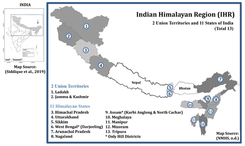
Figure 1Study area: Indian Himalayan region; source: adapted from NMHS (2019) and Siddique et al. (2019).
The IHR represents a significant role in the world's mountain ecosystems (Singh, 2005). The IHR attracts tourists worldwide because of its natural richness, unique biodiversity, and cultural diversity (NITI Aayog, 2018; Gaur and Kotru, 2018). The number of pilgrims has risen dramatically in prominent pilgrim centres across the Himalayas over the ages (Kala, 2014), putting extra stress on these resources and posing a danger of socio-economic loss.
2.2 Multi-hazards in the IHR
Being geologically young and expanding (Wester et al., 2019), the IHR is vulnerable to natural disasters (Gautam et al., 2013). The Himalayas, the world's highest mountain range, is geologically active, fragile, and susceptible to natural and man-made processes (Kala, 2014). Indian geography, climate, topography, and population growth all contribute to its high risk and vulnerability (Sharma et al., 2017). Mountain hazards are widespread, and the hills' characteristics of fragility, restricted accessibility, marginality, and heterogeneity (Gerlitz et al., 2016) may turn a hazard into a catastrophe, transforming mountains into high-risk zones. Furthermore, mountains need a long time to recover from disruptions (Sekhri et al., 2020).
Multi-hazard frequency has risen in recent decades, resulting in massive socio-economic losses (Rehman et al., 2022). Unrecognised practices, irresponsible development initiatives, and a lack of knowledge contribute to disasters having a more significant effect. One of the most challenging aspects of multi-hazard risk assessment is determining how to estimate the risk of several hazards in the same region and how they interact (Hackl et at., 2015).
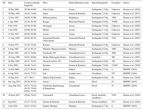
In the recent decades, severe earthquakes, floods, and landslides have devastated the IHR, including the M7.6 Kashmir earthquake in 2005, the Malpa landslide in 2009, the M6.8 Sikkim earthquake in 2011, the 2013 Uttarakhand flash flood, and others, causing approximately thousands of deaths and property losses (MHA, 2011; BMTPC, 2019; Kumar et al., 2016). Table 1 illustrates and describes the major hazard events that have occurred historically in the Indian Himalayan region.
The Himalayan region is among the most seismically active in the world due to the collision of the Indian and Eurasian plates. A series of four major earthquakes has occurred within a short span of 53 years (Srivastava et al., 2015), namely Shillong (1897), Kangra (1905), Bihar–Nepal (1934), and Assam–Tibet (1950). Tectonic activity in the mountains constantly threatens the stability of the mountains, with it being an active region. One of the most frequent natural disasters in the Himalayas occurs when large landslides occur, destroying infrastructure, destroying trees, and killing people. Landslides cause huge social and economic losses to mountain-dwelling populations (Sarkar et al., 2015). The areas which are close to the river valley has witnessed a large number of mass movements during recent years (Srivastava et al., 2010). A recent flash flood, along with a debris flow at Kedarnath on 16–17 June 2013, which claimed over a thousand lives, was caused by cloudbursts and landslides breaching temporary dams along river valleys (Allen, 2015). More than 82 % of the world's population lived on land affected by floods between 1985 and 2003 (Mouri et al., 2013). There is an increase in forest fire frequency globally, especially in Asia. There are major environmental and ecological impacts caused by wildfires, which can result in the fatalities of tens of thousands of people and massive property losses (Parajuli et al., 2020).
2.3 Need of study
Without a comprehensive evaluation of multi-hazards, it is impossible to develop any concrete policy measures to combat the potential risk posed by multiple hazards (Sekhri et al., 2020). With the IHR being prone to multi-hazards (Kala, 2014), risk-resilient development planning is the only way to prepare the Himalayan community from upcoming disasters.
It is well known that the Himalayas are a high-risk area for multi-hazards (Pathak et al., 2019), although fewer risk assessments have been conducted in the IHR region. An assessment of hazards generally focuses on a single threat, such as landslides, earthquakes, or flooding. As a result, physical processes are considered in isolation. In most areas of the Himalayas, hazards are interrelated and generate cascading effects or synergies which make the entire region vulnerable (Sekhri et al., 2020). Probabilistic risk frameworks have been proposed, but as a result of a lack of quality and quantity of data, these approaches are seldom feasible in developing countries (Sanam et al., 2020). Furthermore, the existing risk assessment models and/or tools for a specific hazard in the region have limited application and effectiveness from a policy standpoint (Sekhri et al., 2020).
Researchers are involved in a number of research projects in the IHR in the field of assessing the risk of disasters in India, though there have been very few assessments of hazards associated with the IHR region, none of which incorporate multi-hazards (Wester et al., 2019). In addition, risk resulting from a single hazard is not applicable and cannot be considered effectively in policy analysis in the region (Sekhri et al., 2020).
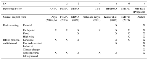
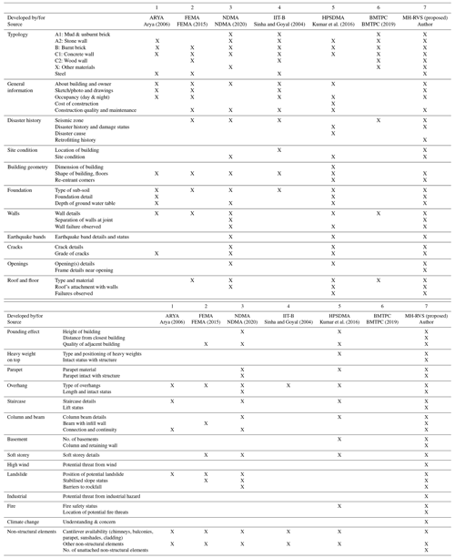
The comparative study of some of the most used survey forms to assess risk in India is shown in the Table 2. Every survey form has its own unique features. In some cases, the focus is largely on one particular hazard, and the other hazards are minor. The details of all the mentioned survey forms will be explained later in Table 4 of this paper. It has been observed from Table 2 that none of the forms (SN 1 to 6) are focusing on multi-hazard risk calculation/identification as per scenarios in the IHR, which is not only prone to earthquakes, but also to floods, landslides, high winds, industrial hazards, falling hazards at a building level (non-structural hazards), fire and electrical hazards, etc.
Furthermore, while working with data collection teams on the ground during disaster risk reduction (DRR) projects, the authors have observed that surveyors face several problems, such as the technically advanced language of the existing survey form, which requires trained technical personnel to fill out, and this leads to costly human resources. Secondly, no graphical explanation of the form leads to a lack of understanding, which further leads to incorrect data collection. Thirdly, most of the above-mentioned forms (Table 2 and Sect. 3.3) are not hill-specific. Fourthly, surveyors are not able to convey the correct objective to the respondent, which creates no interest in the respondent to reply further. MHRA survey forms need to be made easy, simple, informative, and with simple language and/or visual explanation for surveyors as well as respondents to connect to it in order to give and receive information.
The Indian Himalayan region is also a point of attraction for tourists and pilgrims globally, and tourism plays an imperative role in enhancing the economy of the Himalayan state. Thus, safety is an immense need of the government at various levels.
There is no such survey form for comprehensive database for the IHR region for informed decision-making related to multi-hazards and other aspects of sustainable hill development. Considering the IHR scenarios, there is immense need for a hill-specific survey form that can help to gather important information from the field and help in risk assessment for further decision making to prepare the hill community for future disasters.
3.1 Survey form design methodology
The survey methodologies start with a few recommendations for designing a good survey, such as (1) the survey form should satisfy the objectives of the research, (2) there should be an appropriate (but not very long) length of questionnaires coving all essential parts, (3) questions should convey a single thought at a time, (4) language should be simple and easy to understand by the surveyors as well as the respondents, (5) multiple choice questions are mostly preferred to increase response rate, reduce time, and pattern the responses, (6) the survey should be concrete and conform to the respondent's perspective, (7) the use of unclear words should be avoided, and (8) it should meet the survey logic, i.e. there is no further progress or possibility of further correspondence from the respondent if the logic is flawed. It takes practice and verification to ensure that when considering an option only the next logical question comes to mind (Roopa and Rani, 2012).
3.2 Methodology adopted
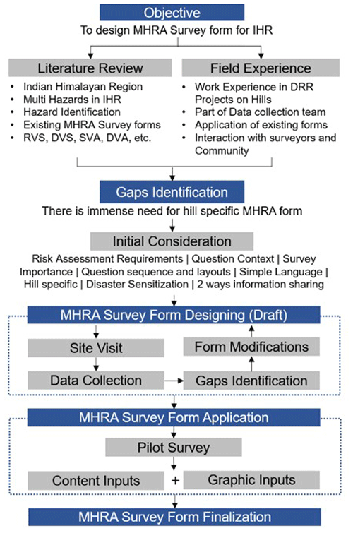
To gather beneficial and appropriate information related to multi-hazards in the Himalayan region, careful attention must be given to the design of the questionnaire that covers all the important contributing factors from various identified hazards and fulfils all the gaps identified from the existing survey form and field experience. Designing an effective questionnaire takes time, effort, and a variety of stages. The methodology to prepare the multi-hazard survey form for the Indian Himalayan region is shown in Fig. 2.
A number of disaster risk reduction projects conducted in the Indian Himalayan region provided Author 1 with a rare opportunity to be part of a data collection team. As a result of these projects, the author has been able to interact on the ground with hill communities and surveyors and has learnt that there are several gaps in the existing survey forms (Sect. 3.4) from both a Himalayan and surveyor perspective. The MHRA survey form contains all the gist of the data collection experience. This research paper is based on a comprehensive literature review (Sect. 3.3) as well as field experience.
To ensure that the survey form was designed in accordance with disaster risk assessment requirements, hill-specific hazards, important components, question sequence and layout, simple language, disaster sensitisation, and two-way information sharing (giving and receiving), some initial considerations were taken into account.
We have designed a draft MHRA survey form (Sect. 4.1) and applied it to some of the buildings in five villages in Uttarakhand (Fig. 5). An initial pilot survey has been conducted at 10 schools (Sect. 4.2) using the proposed survey form with content and graphical inputs. The results and observations relating to the pilot survey are discussed in Sect. 4.2 and 4.5 of this paper.
3.3 Existing multi-hazard risk assessment (MHRA) survey forms
The spread of non-engineering construction, unrecognised construction and planning practices, and reckless developmental activities, as well as a lack of awareness, increase the impact of disasters. The IHR being seismically active, as shown in the seismic zonation map of India, creates the importance of risk assessment of existing buildings. Earthquakes are feared because they are so unpredictable. Yet, as we often hear, “Earthquakes don't kill, Buildings do” (attributed to Francesca Valli, Change Management Thought-Leader), and as the detailed assessment is limited by the number of homes and the cost, one of the considering approaches is rapid visual screening (RVS), which is used for seismic vulnerability assessment. Using this methodology, a risk assessment has been conducted for areas subjected to earthquakes (Kumar et al., 2016).
3.3.1 Seismic zonation map of India
The first seismic zoning map of India was published in 1935 by the Geological Survey of India (GSI) (Fig. 3) (Mohapatra and Mohanty, 2010). Based on the damage that earthquakes caused in various parts of India, this map has undergone numerous modifications (IS-code1893-1, 2002) (Marcussen, 2017; Khattri et al., 1984) since its original creation. As per the Seismic zonation map, India is divided into four distinct seismic risk zones shown here by colour (Dunbar et al., 2003) in Fig. 3.
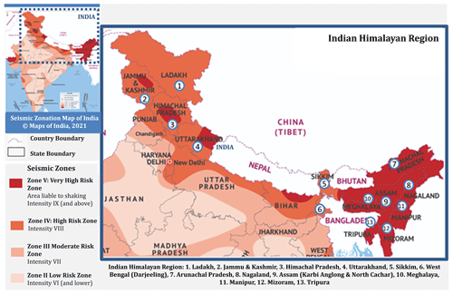
Figure 3Seismic zonation map of India; source: adapted from © Maps of India (https://www.mapsofindia.com/maps/india/seismiczone.htm, last access: 1 April 2023).
3.3.2 About RVS
The Applied Technology Council (ATC) developed the RVS method in the late 1980s and published it in the FEMA: 154 in 1988. In later versions it was revised in FEMA: 178–1989, 1992 (revised), FEMA: 310–1998, and FEMA: 154–1988, 2002 (revised) for rapid visual screening of buildings (Kumar et al., 2016).
Rapid visual screening (RVS) avoids the need for structural calculations by using a visual method. An evaluator determines the damageability grade by identifying (a) the primary structural lateral load resisting system and (b) the structural features of the building that can impact seismic performance in combination with that system. The process of inspecting, gathering data, and deciding on the next course of action occurs on site and may last several hours, depending on the size of the building (Arya, 2006a, b).
Uses of RVS results
The foremost uses of this technique concerning seismic advancement of existing buildings are to assess a building's seismic vulnerability to categorise it further. It is used to determine the structural vulnerability (damageability) of buildings and determine the seismic rehabilitation requirements. In cases where further assessments are not considered necessary or are not feasible, retrofitting requirements are simplified (to a collapse prevention level) (Arya, 2006a, b).
3.3.3 Multi-hazard risk assessment used in India
RVS methodology proposed by Anand S. Arya for masonry buildings
This RVS procedure that was designed for the Indian context follows a grading system where the screener identifies the primary load-resisting system of the building and determines parameters that may be modified to improve the seismic performance of the structure (NDMA, 2020).
The rapid visual screening form of masonry buildings developed by Anand S. Arya consists of zoning according to Indian conditions, and buildings with importance are given consideration. Also, special hazards (liquefiable area, landslide prone area, plan irregularities, and vertical irregularities) and falling hazards are taken into account. Finally, a grading system was performed in the buildings. Refer to Arya (2006a) for the detailed RVS survey forms for masonry buildings.
RVS methodology proposed by Anand S. Arya for reinforced concrete frame or steel frame
The rapid visual screening form of reinforced concrete (RC) frame and steel frame for seismic hazards developed by Anand S. Arya has six components: (i) general information; (ii) building typology based on foundation type, roof, floor, etc.; (iii) structural frame type; (iv) special hazard; (v) non-structural building components; and (vi) damageable grades (Arya, 2006b).
Seismic safety features of RC frame buildings consist of parameters like frame action, presence of soft storey, short column effect, concept of weak beam strong column, pounding of buildings, building distress and other important features, water seepage, corrosion of reinforcement, quality of construction, quality of concrete, and non-structural falling hazards. Refer to Arya (2006a, b) for the detailed RVS survey form for RC and steel buildings.
RVS procedure developed by Sudhir K. Jain
In this method, a checklist for pre-screened buildings is prepared based on Indian conditions. It is one of the first methodologies in India featuring a points system. Performance scores are calculated based on factors such as zone, architectural considerations, structural parameters, and geotechnical characteristics. In India, this method is used in many locations, with the first applications being in Gujarat after the Bhuj earthquake (Jain et al., 2010).
RVS form developed by NDMA 2020
In the Disaster Management Act of 2005, a paradigm shift from a relief-centric approach to mitigation- and preparedness-centric approaches is sought, with continued emphasis on proactive, holistic, and integrated response. With this act in mind, NDMA initiated a series of discrete, comprehensive, and integrated initiatives. Among the recommended actions was assessing earthquake risk within the existing built environment.
NDMA developed this report to make end users aware of RVS's outcomes by presenting RVS in clear and tangible terms. On the basis of discussions with the relevant domain experts, NDMA have developed recommended forms for pre-earthquake and post-earthquake level 1 assessments of seven building typologies (i. reinforced concrete building, ii. burnt clay bricks building, iii. confined masonry building, iv. random rubble masonry building, v. mud house, vi. dhajji dewari, vii. ekra house). A form is developed to categorise the different building attributes into three categories: red (high risk), yellow (moderate risk), and green (low risk) (NDMA, 2020).
Seismic vulnerability assessment by Ravi Sinha and Alok Goyal
Ravi Sinha and Alok Goyal from the Indian Institute of Technology Bombay (IIT-B) prepared a “National Policy for Seismic Vulnerability Assessment of Buildings and Procedure for Rapid Visual Screening of Buildings for Potential Seismic Vulnerability”. A key feature of this procedure is that it allows a trained evaluator to conduct a walk-through of the building to determine vulnerability. It is compatible with GIS-based (geographic information system) city databases and can also be used for a variety of other planning and mitigation tasks (Sinha and Goyal, 2001).
RVS analysed 10 different types of buildings, based on the materials and construction types most commonly found in urban areas. There were both engineered and non-engineered constructions (built according to specifications) in this category (Sinha and Goyal, 2001).
Building vulnerability form developed by HPSDMA & TARU
A form originally prepared by TARU consultancy and the Himachal Pradesh State Disaster Management Authority (HPSDMA) is shown in (Kumar et al., 2016). A building is visually examined by an experienced screener as part of RVS to identify features that contribute to seismic performance. This method is known as a “sidewalk survey”. In this sidewalk survey, checklists are provided for each of the five types of buildings, i.e. RC frames, brick masonry, stone masonry, rammed earth, and hybrid (Kumar et al., 2016).
Vulnerability Atlas of India developed by BMTPC
The Building Materials and Technology Promotion Council (BMTPC) published the Vulnerability Atlas of India as its first edition in 1997 (BMTPC, 2019). It was hailed as a “useful tool for policy planning on natural disaster prevention and preparedness, especially for housing and related infrastructures”. The first of its kind, it provided a means for assessing not only district-level hazards, but also the vulnerability and risks of housing stock. It was greatly utilised by state governments and their agencies in order to develop micro-level action plans on how to reduce the impact of natural disasters, since buildings and housing are commonly damaged or destroyed due to natural disasters, resulting in life losses and disruptions to socio-economic activities.
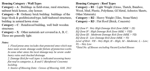
Table 3Damage risk to various housing categories identified by BMTPC under various hazard intensities (BMTPC, 2019). MSK: Medvedev–Sponheuer–Karnik.
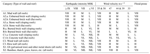
VH: very high risk; H: high risk; M: moderate risk; L: low risk; VL: very low risk.
The revised Atlas published in 2019 reflects advances in scientific and technical knowledge; the addition of new datasets; the results of disasters caused by earthquakes and cyclones; possible damage from landslides, floods, and thunderstorms; the failures of roads and trains during disasters; changes in the political map of the country; and new statistics on walling and roofing data of houses (BMTPC, 2019). Table 3 and Fig. 4 show different housing typologies used in BMTPC based on wall and roof type and material identified in India and also their damage risk under various hazard intensities.
3.3.4 Multi-hazard risk assessment used globally
FEMA 154
The FEMA handbook demonstrates how to rapidly identify, inventory, and rank buildings that are at high risk of causing death, injury, or severe damage in the event of an earthquake. Rapid visual screening (RVS) can be carried out with a short exterior inspection, lasting 15 to 30 min, by trained personnel using the data collection form in the handbook. The guide is targeted at building officials, engineers, architects, building owners, emergency managers, and citizens who are interested in the topic.
Its purpose was to provide an evaluation of the seismic safety of a large inventory of buildings quickly and inexpensively, with minimal access to the buildings, and to identify those that require more detailed examination. FEMA 154 was developed by ATC under contract to FEMA (ATC-21 Project) in 1988. As with its predecessors, the third edition aims to identify, inventory, and screen buildings that present a potential risk. This latest version includes major improvements, such as updating the data collection form and including an optional more detailed page, preparing additional reference guides, and including additional building types that are common, and considerations such as existing retrofits, additions to existing buildings, adjacency, and many others (FEMA, 2015).
Flood vulnerability assessment survey
The flood vulnerability assessment survey form prepared by the Asian Institute of Technology (AIT), Bangkok, and the Climate Technology Centre and Network (CTCN) (Peiris, 2015) has five sections, (i) general information, (ii) type of building, (iii) flood damage and cost, (iv) flood emergency response, and (v) effect on livelihood and income, and was designed for residential, institutional, commercial/industrial, and infrastructure damages. Refer to Singh (2005) for the detailed survey form.
Landslide vulnerability assessment survey
Scientists and researchers focus more on researching landslide susceptibility and the hazard component rather than assessing the vulnerability of buildings to landslides. Even when the same construction material is used, construction practices vary across the country. Currently, there is no standard method for determining building vulnerability by using indicators.
The parts covered by landslide risk assessment survey forms are (i) general information, (ii) building function, and (iii) vulnerability indicators like architectural features, material characteristics, structural features, geographical features, and quality of workmanship, construction and maintenance, etc., which are also covered during RVS and have been covered in the proposed survey from CitSci, the GIS-based data collection app for landslides (Singh et al., 2019).
3.4 Features required for a multi-hazard survey form for IHR
3.4.1 Gaps identified in existing survey forms
Existing survey forms have their strengths and weaknesses. After studying various survey forms for risk assessment prepared by various national and international authorities, it is observed that hill-specific survey forms that can take care of multiple aspects of risk and sustainability assessment together do not exist. Available forms are complicated, are not very user friendly, consist of terminologies difficult to communicate and comprehend, have no pictorial clues for understanding, involve several rounds of calculations for coherent multi-hazard risk evaluation using the data, and most importantly they are not hill site-specific or designed for the Indian Himalayan region.
Hills have their own situation, condition, geography, climate, development trends, construction practices, culture, etc., and they are distinctly different from other regions. RVS is mostly used in India to assess the visual structural vulnerability of the building, as it involves no structural calculations. On the other hand, SVA (simplified vulnerability assessment) and DVA (detailed vulnerability assessment) are for the detailed structural survey of a building and therefore are more precise and use engineering information along with more explicit data on ground motion. Data filling is not easy enough for the surveyor and requires a very high level of engineering knowledge, skills, and experience. Pictorial explanations from a surveyor point of view can ease the communication. Most of the survey forms are focused on single hazards (mostly for seismic evaluation of a building), irrelevant of multi-hazard from Himalayan point of view, and how prone a building's location is to other hazards. Integration between risk understanding and sustainable development is too limited or non-existent. Thus, it has been observed that there is an immense need to design hill-specific questionnaires for multi-hazard risk assessment for the Indian Himalayan region.
3.4.2 Comparative study of some risk assessment survey forms mostly used in India
Table 4 shows the comparative analysis of risk assessment survey forms developed by various organisations and mostly used in India with the proposed multi-hazard RVS. Forms have been compared on various sections like typology, general information, history of disasters, site conditions, building geometry, structural and non-structural component of a building, etc.
4.1 Survey form preparation
The proposed survey form is a modification of the rapid visual screening (RVS) survey questionnaire, i.e. a form used for structural and non-structural components of a building that performs during an earthquake. In the original RVS questionnaire no other hazards are considered. A building's location on a vulnerable site, its structural condition, and its performance can lead to disastrous situations. The other hill-specific hazards are also incorporated into the proposed form to identify the risk components from multi-hazards. Whilst the Himalayan region is prone to earthquakes as per India's Seismic Zonation Map (Fig. 3), the proposed survey form also covers other hazards like landslide, flood, industrial explosion/emissions, fire vulnerability, hydro-climatic factors, etc., which will be addressed one by one in this paper.
4.2 Preliminary survey
Before conducting the pilot survey, a preliminary survey was conducted to test the proposed form, research methodology, and identifying gaps in the existing survey form.
This small assessment also evaluated the RVS form with minor enhancements to evaluate its performance and confirm gaps and to see if it can meet the requirement for risk assessment in other areas with similar geographical characteristics and conditions as experienced in the Indian Himalayan region.
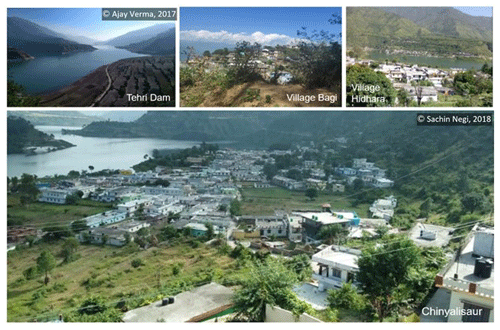
The preliminary survey was conducted at five Gram Panchayats of the Chinyalisaur sub-district in Uttarkashi, Uttarakhand, namely Chinyalisaur, Dhanpur, Dharasu, Hidhara, and Bagi, in October and November 2019, using the draft MHRA survey form. Some of the pictures of the visit are provided in Fig. 5.
The preliminary survey was conducted to determine whether (1) the questions are clearly framed, (2) it covers all the requirements as per hill communities, (3) the wording of the questions are correct enough to lead to the desired outcomes, (4) the questions as well as options for answers suggested are hill-specific or not, (5) the questions are positioned in the most satisfactory order, (6) surveyors and respondents of all classes understand the questions, (7) the questions and their options are self-explanatory or not, (8) the sections in the survey form cover risk-assessment-related questions for all identified hazards or not, (9) the questions as per construction practices and construction materials are available on hills or not, (10) there is any need to add some questions or do some need to be eliminated so as to improve the flow of the survey session, and (11) the surveyor and respondent understand the importance of this survey or the objective behind this survey and have responded in that way.
Table 5Risk score computation; source: adapted from Chouhan et al. (2022b).

SVA: Simplified vulnerability assessment, DVA: detailed vulnerability assessment
4.2.1 Observations during preliminary survey
Feedback from the preliminary study proved very helpful in determining the key gaps and shortcomings of the form design and in informing improvements to the proposed form design. Specifically, (1) the preliminary study showed that a surveyor's observations of a project site, their understanding of each question, and their strategy for convincing the residents to provide accurate data played a significant role in risk assessment. (2) In some questions, the use of technical terms or difficult words, or questions designed to gather too much data at once, discourage respondent interest in responding further and made the surveyor uncomfortable to proceed. (3) The questionnaire may not be self-explanatory and requires someone with civil engineering training to fill it out. (4) Building geometry, construction practices, construction materials, and development trends play an essential role during any hazard; thus, existing building-related questions and options must be incorporated. (5) Survey questions are developed primarily from observations made by survey and engineers as opposed to responses from residents. (6) If the surveyor is not familiar with the terminologies and the aims behind filling out the questionnaire, it leads to no response or the respondents sometimes loosing interest in answering further. (7) An unclear survey vision, an unclear study purpose, and inadequate training of the surveyor will make it difficult to explain the importance of data collection to the respondent, leading to unclear questions and less accurate responses. (8) Surveyors should be trained enough to pick out the correct option from respondents' lengthy responses. (9) There is a need for pictorial representation of answers/options for better understanding of the surveyor. (10) Different answers are obtained when questions are arranged inappropriately or answers are arranged incorrectly. (11) Observing the interaction between multiple hazard types in the same area is a challenging aspect of multi-hazard risk assessment.
4.3 Proposed MHRA form
After the preliminary survey conducted at the Chinyalisaur sub-district, significant points were identified/observed that have been incorporated in the proposed survey form of multi-hazard at hill locations, with all the simple content and graphical inputs for better understanding. Hence, the modifications from a multi-hazard risk point of view and surveyor's point of view can be seen in the proposed form. The proposed survey form can be found in the supplement.
4.4 Risk score computation
After all the parametric studies from various Indian standard codes and reports (URDPFI (2015), IS-13828 (1993), IS-4326 (1993), IS-1893-1 (2016), IS-13935, 2009, IS-15988 (2013)) on ideal building parameters and weak components of a building from the design, construction, site condition, surrounding condition, location, and hazard points of view, risk scores were decided on an average basis on 24 components separately (refer section 4.5 of this paper) for better judgement and understanding. Risk scores were derived from the proposed survey form by appropriately weighing the data points against a risk number chart, with higher weightage given to higher risk (Chouhan et al., 2022b). The data were then aggregated on a scale of 10 (Table 5). For example, if a building answers all weighted MCQs with the highest risk option, it will be scored 10/10, and similarly for low risk and moderate risk. All questions in the questionnaire were not weighted; those with ambiguous risk consequences were left un-weighted to be studied objectively. The risk scores intend to give a relative idea of where the risk lies within a building and among buildings to enable prioritisation during risk-mitigation planning.
4.5 Pilot survey
After finalisation of the proposed MHRA Survey form, a pilot survey was conducted at 10 schools of the Uttarakhand state. The results of the building level survey and campus level survey are shown below in Sect. 4.5.1. and 4.5.2.
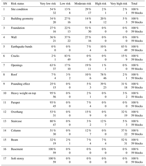
4.5.1 Result of the rapid visual screening survey
As per IS Code 13935 (2009), the key goal of seismic reinforcement is to improve a weakened building's seismic resilience as it is being repaired, making it stronger in the event of potential earthquakes. The individual results of 17 components of RVS are elaborated (Table 6), which highlights the weaker part that needs attention in a building.
4.5.2 Result of the multi-hazard survey
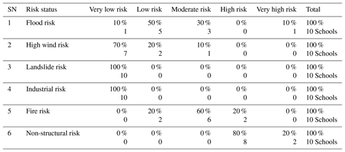
The survey was conducted by considering the campus of the school as one unit. It primarily focuses on the location of the school premises under a vulnerable zone or not and, if yes, to which kind of hazard. It solves the question of how the school campus is prepared. The result of the multi-hazard survey is shown in the Table 7.
The photos of the 10 schools where pilot survey was conducted is shown in the Fig. 6.
5.1 Pilot survey
The IHR requires effective and standardised multi-hazard risk assessment, and for that purpose a custom-designed survey form has been designed to capture the unique characteristics of hill communities and assets. The proposed form performed reasonably well. Effectiveness and data collection is comfortable from both ends, i.e. respondents and surveyor. The questions are properly framed in various sections, the language is simple, and it is easy to interpret. The pictorial explanation makes it easy for surveyors to correct input data, as its explanation is self-explanatory. The objective behind the data collection is well clear to the respondents and the surveyor.
5.2 Key features of the proposed MHRA survey form
The key features of the proposed form are that it is specially designed for data collection in the Indian Himalayan region regarding risk of earthquake, flood risk, high wind risk, industrial hazard, non-structural risk, fire vulnerability, and climate change awareness. As the value addition, the proposed survey form consists of questions related to climate change, as the promotion of self-mobilisation and action is enhanced by awareness; it increases enthusiasm and support. It is therefore crucial to raise awareness about climate change adaptation in order to manage the impacts of climate change, increase adaptive capacity, and reduce overall vulnerability.
The proposed survey form is very useful for any type of study related to hazard risk assessment in hills. Time taken to complete the questionnaire, i.e. the length of the questionnaire, is good enough, i.e. 10 min for the trained civil engineer and 17 min for the trained non-engineering background surveyor. With practice, the surveyor can reduce time. The language of the form is simple and specific, i.e. one answer on one dimension is required, it considers all possible contingencies when determining a response, and it is designed in a way that it collects more and more accurate information in less time. Questionnaires permit the collection and analysis of quantitative data in a standardised manner, ensuring their internal consistency and coherence. The question sequence is clear and smooth-moving. By sequencing questions properly, the chances of misinterpreting individual questions are greatly reduced. The pictorial options make it comfortable for the surveyor to fill in the answer by looking at the building.
The survey form is divided into sections so that only one thought can be conveyed at a time. It includes the advanced version of RVS that covers risk status for foundation, wall, roof, openings, beam, column, site conditions, etc. of a building. It is covering all the points required for building analysis in RVS. It covers questions related to all identified hazards that are directly or indirectly contributing to risk factors. It covers all the required questions as per hill condition, situation, climate, geography, construction practices, construction materials, etc. The format, including the font and layout, is good enough to be read by the surveyor. Before going into the field, the surveyor must require a reading of the full survey form carefully with all terminologies clear. It includes non-structural risk survey questions. The safety of occupants in a building following an incident can be at risk due to reduced capacity of structural components or damage to non-structural components. This hill-specific MHRA questionnaire survey may act as a risk sensitisation tool.
5.3 Result of the pilot survey
It can be seen that the detailed multi-hazard risk assessment will help the schools to identify the potential threats presented in the building as well as the premises and the steps to retrofit the structure.
Due to the region's strong earthquake zonation, RVS and NSRA (non-structural risk assessment) data suggest high structural and non-structural vulnerability in almost all the 10 schools (Fig. 6), which assumes greater significance. On the other hand, schools need to improve their fire safety measurement and training. High wind and floods pose a prominent moderate to high risk. Industry and landslides, on the other hand, pose no risk. The risk of fire arises from a shortage of fire safety equipment and structural issues such as the absence of an alternate staircase, the incorrect placement of fire-risk properties, etc. Fire disasters have the potential to be catastrophic, but this should be a top priority as we advance. The wind is a significant concern in this region because it is vulnerable to frequent windstorms. High-speed winds pose a risk in the form of hazardous trees/towers, flying objects, and weakly latched doors/windows.
Heavy furniture (tables, cabinets) and hanging electrical items/wire products face a considerable risk of falling in the case of a tragedy in different rooms and labs. Falling hazards can obstruct escape routes and injure people as they collide with them during minor seismic shaking/earthquakes. When a disaster strikes, it is crucial for students and workers to have as little disruption as possible during the critical reaction time. Mitigation measures primarily involve simple fixes of non-structural elements with the structural element (wall and floor) and are hence, for the most part, low-cost solutions.
Overall, the total risk is rated moderate on the risk scale, considered by the authors after structural and non-structural factors.
The Indian Himalayan region is facing disaster every year with significant loss of life and property, as it is very prone to multi-hazards. Thousands of studies and projects and large amounts of research are funded nationally and internationally to minimise the loss and prepare the community to face the upcoming disaster.
A questionnaire is the backbone for any survey, which is the base for all types of research work for better accuracy. This article describes why there is a need for a hill-specific survey form that focuses on the multi-hazards in hills and hill's existing scenarios. It then described the steps of how a hill-specific multi-hazard risk assessment survey form was developed, validated through pilot survey, and tailored specifically for hill communities.
This article identifies gaps in the existing survey form used in India for risk assessment and highlights the problem faced by the surveyors on the ground while filling out these survey forms. The proposed form is self-explanatory, pictorial, simple, easy to understand, covers hill-specific important components, and addresses several hazards such as earthquakes, floods, high wind, landslides, industrial hazard, fire vulnerability, and non-structural risk in the building.
The proposed survey form designed and applied under this study will help all the stakeholders to collect better information from the field and make it easy for the surveyors to understand, even for a non-technical person. This form will also identify the weak components of a building, construction practices, the development trend, and the vulnerability of the location, so that future construction can be planned considering the risk factors and vulnerable zones. Most of the assessment criteria for multi-hazard risks are met by the proposed survey form. The more accurate the data, the better its results will be.
The preliminary survey conducted at the Chinyalisaur district of Uttarakhand validated the questionnaire and survey form and provided invaluable feedback now incorporated into the final survey form design. Through preliminary and pilot surveys, it has been observed that the proposed form is designed in a way that it can collect more accurate information in less time. Questionnaires permit the collection and analysis of quantitative data in a standardised manner, ensuring their internal consistency and coherence. The language and sequence of questions is designed for clear and easy communication. Pictorial explanations of questions, the unique feature, provides easy flow of information between the respondents and surveyors. Thus, this hill-specific MHRA questionnaire survey may act as a risk sensitisation tool.
The survey form is divided into various sections that cover firstly building-specific questions, as buildings play crucial roles during any hazard, and secondly location specific questions that cover the vulnerability of buildings towards other hazards. The result of the pilot survey highlights the risk status for various components of a building, which will help further in utilising the retrofitting and renovation budget in a fruitful and planned way. On the other hand, the result of the pilot survey also shows location-wise vulnerability, i.e. vulnerability of the building towards other hazards that can help further in decision making related to disaster reduction, preparedness, and planning strategies at that location for that particular identified hazard. It will also help us to understand the development trend in that particular location and take action for future development strategies.
The suggested form is a proposed version of rapid visual screening (RVS), which can assess the risk of any structure and includes all structural and non-structural components that respond during a seismic event. It also includes information about the building's sensitivity to possible danger zones such as landslides, floods, wind, and industrial hazards.
This study has the scope of application in other Asian countries within Himalayas like Nepal, Bhutan, China, and Pakistan. Its international application will enhance the survey form and scope for future research. The proposed survey form will not only act as self-sensitisation for the building owners at a micro level, but also have good scope at a regional level, i.e. macro level, when results of all the buildings will be on a single screen. The data collected using this form can be used in any study related to multi-hazard risk assessment. It can be used by civil engineers as well as people with a non-civil engineering background. People can self-assess their building. To do this effectively, it is crucial to reinforce the networks of science, technology, and decision-makers and create a sustainable technological outcome for disaster risk reduction.
This article is a part of doctoral research, and the data collection was done by the first author physically on-site. The data are available from the authors by request.
The supplement related to this article is available online at: https://doi.org/10.5194/nhess-23-1267-2023-supplement.
All authors contributed to the idea, conceptualisation and scope of the paper. SC performed the data collection and analysis and wrote the manuscript. MM supervised the work, developed the methodology, discussed the results and contributed to the writing of the paper.
The contact author has declared that none of the authors has any competing interests.
Publisher's note: Copernicus Publications remains neutral with regard to jurisdictional claims in published maps and institutional affiliations.
This article is part of the special issue “Estimating and predicting natural hazards and vulnerabilities in the Himalayan region”. It is not associated with a conference.
This research was financially supported by the National Mission for Himalayan Studies (NMHS, grant no. NMH_DMC_1334). We would like to thanks CoPREPARE – An Indo German Project (grant no. IGP2020-24/COPREPARE) for their mentorship. We are indebted to the local residents who actively participated in the household survey. The authors are grateful to Tom Burkitt, from DHI, for editorial support and proofreading.
This research has been supported by the NMHS – National Mission on Himalayan Studies (grant no. NMH_DMC_1334).
This paper was edited by Kristen Cook and reviewed by four anonymous referees.
Aksha, A. K., Resler, L. M., Juran, L., and Carstensen, L. W.: A geospatial analysis of multi-hazard risk in, Geomatics, Nat. Hazards Risk, 11, 88–111, https://doi.org/10.1080/19475705.2019.1710580, 2020.
Allen, S. K., Rastner, P., Arora, M., Huggel, C., and Stoffel, M.: Lake outburst and debris flow disaster at Kedarnath, June 2013: hydrometeorological triggering and topographic predisposition, Landslides, 13, 1479–1491, https://doi.org/10.1007/s10346-015-0584-3, 2015.
Arya, A. S.: Rapid Visual Screening of RCC Buildings, Prepared Under GOI – UNDP Disaster Risk Management Programme, Ministry of Home Affairs, India, 14 pp., https://nidm.gov.in/PDF/safety/earthquake/link10.pdf (last access: 1 April 2023), 2006a.
Arya, A. S.: Rapid Visual Svreening of Masonry Buildings, GOI – UNDP Disaster Risk Management Programme, 13935, 17–41, https://nidm.gov.in/PDF/safety/earthquake/link11.pdf (last access: 1 April 2023), 2006b.
BMTPC: Vulnerability Atlas of India: 3rd edition, Ministry of Housing and Urban Affairs, Government of India, India, 478 pp., https://vai.bmtpc.org/ (last access: 11 February 2023), 2019.
Buck, K. D. and Summers, J. K.: Application of a multi-hazard risk assessment for local planning local planning, Geomatics, Nat. Hazards Risk., 11, 2058–2078, https://doi.org/10.1080/19475705.2020.1828190, 2020.
Chandel, V. B. S. and Brar, K. K.: Seismicity and vulnerability in Himalayas: the case of Himachal Pradesh, India, Geomatics, Nat. Hazards Risk., 1, 69–84, https://doi.org/10.1080/19475701003643441, 2010.
Chouhan, S., Narang, A., and Mukherjee, M.: Multi-Hazard Risk Assessment of Schools in Lower Himalayas: Haridwar District, Uttarakhand, India, EGU General Assembly 2022, Vienna, Austria, 23–27 May 2022, EGU22-4333, https://doi.org/10.5194/egusphere-egu22-4333, 2022a.
Chouhan, S., Narang, A., and Mukherjee, M.: Multihazard risk assessment of educational institutes of Dehradun, Uttarakhand, Int. J. Disaster Resil. Built Environ., ISSN 1759-5908, https://doi.org/10.1108/IJDRBE-08-2021-0091, 2022b.
COI-Census of India: Data and Resources-Population Census, https://censusindia.gov.in/census.website/ (last access: 16 July 2022), 2011.
Disasters in Himalayan Region: The Hindu Kush Himalaya assessm, https://library.oapen.org/handle/20.500.12657/22932 (last access: 16 July 2022), 2007.
Dunbar, P. K., Bilham, R. G., and Laituri, M. J.: Earthquake Loss Estimation for India Based on Macroeconomic Indicators, Risk Science and Sustainability, edited by: Beer, T. and Ismail-Zadeh, A., NATO Science, Vol. 112, Springer, Dordrecht, 163–180, https://doi.org/10.1007/978-94-010-0167-0_13, 2003.
FEMA: Rapid Visual Screening of Buildings for Potential Seismic Hazards: A Handbook, 3rd edn., Federal Emergency Management Agency, Washington, 388 pp., https://www.fema.gov/sites/default/files/2020-07/fema_earthquakes_rapid-visual-screening-of-buildings-for-potential-seismic-hazards-a-handbook-third-edition-fema-p-154.pdf (last access: 1 April 2023), 2015.
Gerlitz, J. Y., Macchi, M., Brooks, N., Pandey, R., Banerjee, S., and Jha, S. K.: The Multidimensional Livelihood Vulnerability Index – an instrument to measure livelihood vulnerability to change in the Hindu Kush Himalayas, Clim. Dev., 9, 124–140, https://doi.org/10.1080/17565529.2016.1145099, 2016.
Goodrich, C. G., Prakash, A., and Udas, P. B.: Gendered vulnerability and adaptation in Hindu-Kush Himalayas: Research insights, Environ. Dev., 31, 1–8, https://doi.org/10.1016/j.envdev.2019.01.001, 2018.
Gautam, M. R., Timilsina, G. R., and Acharya, K.: Climate Change in the Himalayas: Current State of Knowledge, World Bank Policy Research Working Paper No. 6516, SSRN, 64 pp., https://doi.org/10.1596/1813-9450-6516, 2013.
Gaur, V. S. and Kotru, R.: Sustainable Tourism in the Indian Himalayan Region, Report of Working Group II, NITI Aayog-Government of India, India, 100 pp., http://scstsenvis.nic.in/WriteReadData/links/Report%20of%20Working%20Group%20II-86489280.pdf (last access: 1 April 2023), 2018.
Hackl, J., Adey, B. T., and Heitzler, M.: An Overarching Risk Assessment Process to Evaluate the Risks Associated with Infrastructure Networks due to Natural Hazards, Int. J. Perform. Eng., 11, 153–168, https://hal.science/hal-01575239/ (last access: 1 April 2023), 2015.
IS-code13828-1993: Indian Standard Improving Earthquake Resistance of Low Strength Masonry Buildings-Guidelines, Indian Standard Codes- guidelines, Bureau of Indian Standards, New Delhi, 22 pp., https://archive.org/details/gov.law.is.13828.1993 (last access: 1 April 2023), 2008.
IS-code13935-2009: Indian Standard Seismic Evaluation, Repair And Strengthening Of Masonry Buildings-Guidelines ( First Revision), Indian Standard Codes- guidelines, Bureau of Indian Standards, New Delhi, 44 pp., https://archive.org/details/gov.in.is.13935.2009 (last access: 15 March 2023), 2009.
IS-code1893(1)2002: Indian Standard Criteria for Earthquake Resistant Design of Structures Part 1 General Provisions and Buildings (Fifth Revision), Indian Standard Codes- guidelines, Bureau of Indian Standards, New Delhi, 45 pp., https://archive.org/details/gov.in.is.1893.1.2002 (last access: 18 March 2023), 2002.
IS-code1893(1)2016: Indian Standard Criteria for Earthquake Resistant Design of Structures Part 1 General Provisions and Buildings (Fifth Revision), Indian Standard Codes- guidelines, Bureau of Indian Standards, New Delhi, 44 pp., https://archive.org/details/1893Part12016 (last access: 22 February 2023), 2016.
IS-code4326-1993: Indian Standard Earthquake Resistant Design and Construction of Buildings – Code of Practice (Second Revision), Indian Standard Codes – guidelines, Bureau of Indian Standards, New Delhi, 41 pp., https://archive.org/details/7.Is.4326.1993 (last access: 4 December 2022), 1993.
Jain, S. K., Mitra, K., Kumar, M., and Shah, M.: A Rapid Visual Seismic Assessment Procedure for RC Frame buildings in India, in: Proceedings of the 9th U.S. National and 10th Canadian Conference on Earthquake Engineering, Toronto, Ontario, Canada, 25–29 June 2010, Paper No 972, https://doi.org/10.13140/2.1.2285.0884, 2010.
Kala, C. P.: Deluge, disaster and development in Uttarakhand Himalayan region of India-Challenges and lessons for disaster management, Int. J. Disaster Risk Reduct., 8, 143–152, https://doi.org/10.1016/j.ijdrr.2014.03.002, 2014.
Khattri, K. N., Rogers, A. M., Perkins, D. M., and Algermissen: A seismic hazard map of india and adjacent areas, Tectonophysics, 108, 93–108, 111–134, https://doi.org/10.1016/0040-1951(84)90156-2, 1984.
Kumar, S. A., Rajaram, C., Mishra, S., Kumar, R. P., and Karnath, A.: Rapid visual screening of different housing typologies in Himachal Pradesh, India, Nat. Hazards, 85, 1851–1875, https://doi.org/10.1007/s11069-016-2668-3, 2016.
Marcussen, E.: Explaining the 1934 Bihar-Nepal Earthquake: The Role of Science, Astrology , and “ Rumours” , in: Historical Disaster Experiences. Transcultural Research – Heidelberg Studies on Asia and Europe in a Global Context, edited by: Schenk, G., Springer, Cham., 241–266, https://doi.org/10.1007/978-3-319-49163-9, 2017.
Map of India: Seismic Zonation Map, https://www.mapsofindia.com/maps/india/seismiczone.htm (last access: 16 January 2022), 2021.
MHA (Ministry of Home Affairs): Disaster Management Division, https://www.mha.gov.in/en/divisionofmha/disaster-management-division (last access: 16 July 2022), 2011.
Mohapatra, A. K. and Mohanty, W. K.: An Overview of Seismic Zonation Studies in India, in: Indian Geotechnical Conference, GEOtrendz, 16–18 December 2010, 175–178, https://gndec.ac.in/~igs/ldh/conf/2010/articles/043.pdf (last access: 1 April 2023), 2010.
Mouri, G., Minoshima, D., Golosov, V., Chalov, S., Seto, S., Yoshimura, K., Nakamura, S., and Oki, T.: Probability assessment of flood and sediment disasters in Japan using the Total Runoff-Integrating Pathways model, Int. J. Disaster Risk Reduct., 3, 31–43, https://doi.org/10.1016/j.ijdrr.2012.11.003, 2013.
NDMA: A Primer on Rapid Visual Screening (RVS) Consolidating Earthquake Safety Assessment Efforts in India, Manual and Guidelines, National Disaster Management Authority, Government of India, India, 75 pp., https://ndma.gov.in/sites/default/files/PDF/Technical%20Documents/RVS-Doc-11-2020.pdf (last access: 1 April 2023), 2020.
NITI Aayog: Report of Working Group II Sustainable Tourism in the Indian Himalayan Region https://www.niti.gov.in/writereaddata/files/document_publication/Doc2.pdf (last access: 25 January 2022), 2018.
NMHS (National Mission on Himalayan Studies): Executive Summary, https://nmhs.org.in/Overview.php (last access: 1 April 2023), 2019.
Parajuli, A., Gautam, A. P., Sharma, S. P., Bhujel, K. B., Sharma, G., Thapa, P. B., Bist, B. S., and Poudel, S.: Forest fire risk mapping using GIS and remote sensing in two major landscapes of Nepal, Geomatics, Nat. Hazards Risk., 11, 2569–2586, https://doi.org/10.1080/19475705.2020.1853251, 2020.
Pathak, R., Negi, V. S., Rawal, R. S., and Bhatt, I. D.: Alien plant invasion in the Indian Himalayan Region: state of knowledge and research priorities, Biodivers. Conserv., 28, 3073–3102, https://doi.org/10.1007/s10531-019-01829-1, 2019.
Peiris, T. A.: Flood Risk Assessment for Dungsum Chu Basin in Samdrup Jonkhar, Data Collection Report, Climate Technology Centre and Network (CTCN) and Asian Institute of Technology (AIT), Bhutan, 33 pp., https://www.ctc-n.org/system/files/dossier/3b/ctcn_bhutan_data_collection_report.pdf (last access: 1 April 2023), 2015.
Rehman, A., Song, J., Haq, F., Mahmood, S., Ahamad, M. I., Basharat, M., and Mehmood, M. S.: Multi-Hazard Susceptibility Assessment Using the Analytical Hierarchy Process and Frequency Ratio Techniques in the Northwest Himalayas, Pakistan, Int. J. Remote Sens, 14, 1–31, https://doi.org/10.3390/rs14030554, 2022.
Roopa, S. and Rani, M.: Questionnaire Designing for a Survey, J. Indian Ortho. Soc., 46, 273–277, https://doi.org/10.1177/0974909820120509s, 2012.
Sanam, K. A., Lynn, M. R., Luke, J., and Laurence Jr., W. C.: A geospatial analysis of multi-hazard risk in Dharan, Nepal, Geomatics, Nat. Hazards Risk., 11, 88–111, https://doi.org/10.1080/19475705.2019.1710580, 2020.
Sarkar, S., Kanungo, D. P., and Sharma, S.: Landslide hazard assessment in the upper Alaknanda valley of Indian Himalayas, Geomatics, Nat. Hazards Risk., 6, 308–325, https://doi.org/10.1080/19475705.2013.847501, 2015.
Sekhri, S., Kumar, P., Fürst, C., and Pandey, R.: Mountain specific multi-hazard risk management framework (MSMRMF): Assessment and mitigation of multi-hazard and climate change risk in the Indian Himalayan Region, Ecol. Indic., 118, 106700, https://doi.org/10.1016/j.ecolind.2020.106700, 2020.
Sharma, S., Roy, P. S., Chakravarthi, V., Srinivasarao, G., and Bhanumurthy, V.: Extraction of detailed level flood hazard zones using multi-temporal historical satellite data-sets – a case study of Kopili River Basin, Assam, India', Geo Nat Hazards Risk., 13, 2227–2251, https://doi.org/10.1080/19475705.2016.1265014, 2017.
Siddique, M. I., Desai, J., Kulkarni, H., and Mahamuni, K.: Comprehensive report on Springs in the Indian Himalayan Region, Report number: ACWA/Hydro/2019/H88, Advanced Center for Water Resouces Development and Management, India, 198 pp., https://doi.org/10.13140/RG.2.2.12104.06408, 2019.
Singh, J. S.: Sustainable development of the Indian Himalayan region: Linking ecological and economic concerns, Curr. Sci., 90, 784–788, 2005.
Singh, A., Kanungo, D. P., and Pal, S.: Physical vulnerability assessment of buildings exposed to landslides in India, Nat Hazards, 96, 753–790, https://doi.org/10.1007/s11069-018-03568-y, 2019.
Sinha, R. and Goyal, A.: A National Policy for Seismic Vulnerability Assessment of Buildings and Procedure for Rapid Visual Screening of Buildings for Potential Seismic Vulnerability, Report, Indian Institute of Technology Bombay, Mumbai, 12 pp., https://www.civil.iitb.ac.in/~rsinha/Vulnerability_Assessment.pdf (last access: 1 April 2023), 2001.
Srivastava, H. N., Verma, M., Bansal, B. K., and Sutar, A. K.: Discriminatory characteristics of seismic gaps in Himalaya, Geomatics, Nat. Hazards Risk., 6, 224–242, https://doi.org/10.1080/19475705.2013.839483, 2015.
Srivastava, V., Srivastava, H. B., and Lakhera, R. C.: Fuzzy gamma based geomatic modelling for landslide hazard susceptibility in a part of Tons river valley, northwest Himalaya, India. Geomatics, Nat. Hazards Risk., 1, 225–242, https://doi.org/10.1080/19475705.2010.490103, 2010.
UNDRR: Sendai Framework Terminology on Disaster Risk Reduction, https://www.undrr.org/terminology#R, last access: 30 January 2022.
URDPFI: Urban and Regional Development Plans formulation and implementation (URDPFI) Guidelines, 1, Town and Country Planning Organization, Ministry of Urban Development, Government of India, 447 pp., https://mohua.gov.in/upload/uploadfiles/files/URDPFI%20Guidelines%20Vol%20I(2).pdf (last access: 3 April 2023), 2015.
Wester, P., Mishra, A., Mukherji, A., and Shrestha, A. B. (Eds.): The Hindu Kush Himalaya Assessment, Springer Nature, Nepal, 627 pp., https://doi.org/10.1007/978-3-319-92288-1, 2019.


